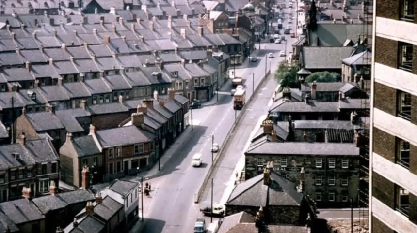
Arthur’s Hill is a historic residential neighbourhood in the west of Newcastle upon Tyne, Tyne and Wear, England. Its identity reflects the city’s nineteenth-century expansion, the growth of working-class housing, the development of local streets and shops, and the movement of people into Newcastle during industrialisation. Victorian terraced houses remain an important part of the area’s built environment, providing evidence of how urban communities developed beyond the historic city centre.
- What Is Arthur’s Hill and Where Is the Neighbourhood Located?
- How Did Arthur’s Hill Become Part of Newcastle’s West End?
- What Makes Arthur’s Hill Historically Significant?
- Why Did Newcastle Expand During the Victorian Period?
- How Did Industrial Employment Influence Residential Development?
- What Role Did Newcastle’s Transport Networks Play?
- When Were Arthur’s Hill’s Victorian Terraced Houses Built?
- Why Did Builders Construct Terraced Houses?
- How Can the Age of an Arthur’s Hill Property Be Verified?
- What Architectural Features Define Victorian Terraced Houses in Arthur’s Hill?
- Why Are Brick Façades and Repeated Frontages Important?
- What Do Victorian Windows, Roofs and Doorways Reveal?
- How Did Household Needs Shape the Interior Layout?
- How Did Working-Class Families Live in Arthur’s Hill’s Terraced Streets?
The history of Arthur’s Hill is closely connected to Newcastle’s wider transformation during the Industrial Revolution. As employment expanded in manufacturing, engineering, transport and trade, the city needed more homes for its growing population. Residential streets spread westwards, connecting established settlements with newer urban districts. Builders constructed rows of houses on relatively narrow plots, creating a dense residential landscape that supported families, local businesses and neighbourhood institutions.
Arthur’s Hill subsequently developed through changing economic conditions, population movements, housing improvements and investment in public services. Its streets reflect the relationship between architecture and everyday life in an industrial city. Understanding this history explains why Victorian terraces, traditional street layouts and local community spaces remain significant to Arthur’s Hill today.
What Is Arthur’s Hill and Where Is the Neighbourhood Located?
Arthur’s Hill is a residential neighbourhood in west Newcastle upon Tyne, within Tyne and Wear in northeast England. Its location connects the wider city’s industrial history with nineteenth-century housing growth, local shopping streets and established communities. The neighbourhood forms part of Newcastle’s wider West End, an area shaped by urban expansion and successive waves of migration.
Newcastle upon Tyne developed around the River Tyne, which supported trade, shipbuilding, manufacturing and transport. As the city expanded, residential development moved beyond its older commercial and administrative centre. Districts in the West End accommodated people who needed access to employment, shops, schools and public transport.
Arthur’s Hill belongs to this wider pattern of urban growth. Its built environment includes residential streets, local services and housing associated with the expansion of Newcastle during the nineteenth and twentieth centuries. The neighbourhood’s development cannot be separated from the growth of neighbouring districts, including Elswick and Fenham, although each area has its own geographical boundaries and historical character.
How Did Arthur’s Hill Become Part of Newcastle’s West End?
Newcastle’s western districts expanded as the city’s population and economic activity increased. Housing developers built beyond the historic centre to accommodate workers and their families. Roads and residential streets gradually linked developing neighbourhoods with established employment areas and commercial routes.
The term West End describes a broad part of Newcastle rather than a single historic settlement. It includes residential communities that developed at different times and under different economic conditions. Arthur’s Hill’s position within this wider area helps explain its relationship with nearby housing districts and the city’s industrial past.
The distinction between a neighbourhood and a formally defined administrative area is important. Arthur’s Hill is commonly used as a local place name, while council wards, census areas and planning boundaries follow their own definitions. Historical population figures therefore need to be matched to the precise boundary being examined.
What Makes Arthur’s Hill Historically Significant?
Arthur’s Hill provides an example of how nineteenth-century urban expansion changed Newcastle’s residential geography. Its significance lies in the relationship between housing, employment, street planning and community development. Victorian terraces offer physical evidence of the building practices and household arrangements associated with industrial-era cities.
The area also illustrates how neighbourhoods change over time without losing every feature of their earlier development. Older buildings can remain in residential use while their interiors, ownership, occupants and surrounding services change. This continuity makes the streets useful for understanding the long-term evolution of Newcastle’s West End.
Why Did Newcastle Expand During the Victorian Period?
Newcastle expanded during the Victorian period, from 1837 to 1901, because industrial employment, trade, transport and population growth increased demand for urban housing. New residential districts developed around established roads and employment centres, creating the conditions for terraced streets in the West End.
The Victorian period coincided with major changes in Britain’s economy and settlement patterns. Industrialisation concentrated employment in cities, while railways, shipping and commercial networks connected urban centres to wider markets. Newcastle benefited from its position on the River Tyne and its established links with coal, engineering, shipbuilding and regional trade.
These industries generated employment directly and indirectly. Workers needed housing within practical travelling distance of factories, workshops, docks, shops and other workplaces. Businesses also required customers, suppliers and employees, encouraging the expansion of residential streets and local commercial centres.
Newcastle’s growth was part of a national trend. Across industrial Britain, towns and cities expanded as people moved from rural areas and smaller settlements in search of paid work. The pace and form of development varied between neighbourhoods according to land ownership, transport access, building costs and local employment patterns.
How Did Industrial Employment Influence Residential Development?
Industrial employment created demand for homes across different price ranges. Labourers, skilled tradespeople, shop workers and their families needed accommodation close enough to reach work regularly. Developers responded by dividing available land into building plots and constructing rows of houses.
Terraced housing suited this demand because adjoining homes shared side walls. This arrangement allowed builders to accommodate many households along a street without requiring detached buildings and large individual plots. The resulting density supported nearby shops, schools, places of worship and other services.
The connection between employment and housing was not always straightforward. Household incomes varied, and workers did not all live near the same workplaces. Some residents walked to work, while others used public transport or moved between jobs as the economy changed.
Arthur’s Hill formed part of a wider residential landscape shaped by these pressures. Its history reflects the practical need to accommodate a growing urban population rather than a single building project or one industrial employer.
What Role Did Newcastle’s Transport Networks Play?
Transport networks supported Newcastle’s expansion by moving people, goods and building materials. The River Tyne connected the city to maritime trade, while railways strengthened links with other industrial centres. Roads and local transport services also influenced where people lived and worked.
The spread of housing into the West End depended on access to the wider city. Streets became more useful to residents when they connected homes with employment, markets, schools and public services. Improved transport could also increase the attractiveness of areas farther from older commercial districts.
However, the existence of a transport route does not establish that it directly caused a particular Arthur’s Hill street to develop. Street-level histories require evidence from historic maps, building records, directories and local archives. These sources help establish when individual roads appeared and how they related to changing transport networks.
When Were Arthur’s Hill’s Victorian Terraced Houses Built?
Arthur’s Hill’s Victorian terraced houses belong to the wider tradition of nineteenth-century urban housing that expanded across Newcastle during industrial growth. The construction date of an individual property requires verification through historic maps, property records, census evidence or local architectural research.
The term Victorian refers to the reign of Queen Victoria, from 1837 to 1901. It describes a long period of architectural and social change rather than one uniform house style. Buildings from the early Victorian decades differ from those constructed during the late nineteenth century.
Newcastle’s urban expansion accelerated as demand for residential accommodation increased. Terraced houses provided a practical response to limited urban land and the need for relatively affordable homes. Rows of adjoining properties appeared in many industrial cities, including Newcastle, where residential development followed changing patterns of employment and population growth.
A Victorian appearance does not, by itself, prove that a house dates from the nineteenth century. Later buildings sometimes reproduced older architectural features, while nineteenth-century properties often received substantial alterations. Reliable dating therefore combines visible evidence with documentary records.
Why Did Builders Construct Terraced Houses?
Terraced houses consist of individual dwellings arranged in a continuous row, usually sharing party walls with neighbouring properties. Each house generally has its own entrance, internal accommodation and street frontage. The arrangement uses land efficiently while providing separate homes for multiple households.
Builders could repeat similar floor plans and construction details along a street. Repetition reduced the need to design every house independently and created a consistent building line. Variations in materials, ornament and internal layouts reflected construction dates, budgets and the intended market.
Terraces also shaped how residents used their neighbourhood. Front doors opened directly onto streets, while small rear yards or gardens provided additional domestic space. Shops and other commercial premises sometimes occupied ground-floor positions on suitable streets, bringing everyday services closer to residential areas.
These characteristics explain why terraced housing became a defining feature of many industrial towns. The form was practical, but its success also depended on the availability of land, construction materials, local building traditions and household demand.
How Can the Age of an Arthur’s Hill Property Be Verified?
Property age is best established by comparing several independent records. Historic Ordnance Survey maps can show when a street or building footprint first appeared. Census returns and trade directories can identify occupants and businesses at particular dates. Deeds, title records and planning documents can provide further evidence about ownership and alterations.
The National Library of Scotland provides access to historical maps of Britain, including Ordnance Survey mapping that helps researchers compare urban landscapes across different periods. Newcastle City Council’s archives and local studies collections are also relevant sources for researching the development of individual streets.
Architectural details can support documentary research. Brickwork, roof forms, window proportions, door surrounds and decorative stonework sometimes indicate a building’s period. These features are not conclusive on their own because owners frequently replace windows, alter entrances, extend rear rooms and modernise interiors.
A sound property history distinguishes the age of the original building from the date of later alterations. A house constructed in the nineteenth century, for example, can contain twentieth-century windows, replacement roofing and modern internal services.
What Architectural Features Define Victorian Terraced Houses in Arthur’s Hill?
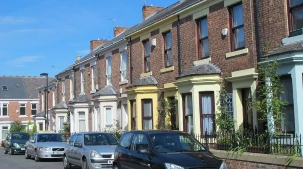
Victorian terraced houses typically feature repeated street-facing façades, brick construction, pitched roofs and compact plots. Depending on their date and original cost, individual properties also contain sash windows, stone or brick lintels, decorative door surrounds and rear extensions.
Victorian architecture was diverse. Industrial cities contained modest workers’ houses alongside larger terraces built for better-paid households. The differences reflected the cost of construction, the intended occupants and the preferences of local builders.
In Newcastle, the appearance of a residential street also depended on available building materials and regional construction practices. Brick became a major material in many nineteenth-century urban developments, while stone and decorative masonry appeared in features such as window surrounds, steps and lintels.
The architecture of an individual Arthur’s Hill property needs to be assessed directly. Not every house has retained its original windows, doors or decorative details. Some streets also contain buildings from different periods, so describing the entire neighbourhood as uniformly Victorian would oversimplify its development.
Why Are Brick Façades and Repeated Frontages Important?
Brick façades provided durable external walls and allowed builders to create consistent rows of houses. Repeated frontages established a clear street line, while variations in brick colour, window placement and entrance design introduced visual differences between individual properties.
A continuous terrace also influenced the scale of the street. Closely spaced entrances and relatively narrow plots created a built environment suited to walking and local daily activity. Where shops, schools and community buildings developed nearby, the street network helped connect residential life with essential services.
The survival of original brickwork provides evidence of construction methods and building materials. Repointing, replacement bricks, paint and external insulation can change the appearance of older walls, making careful inspection important when assessing a property’s historic fabric.
What Do Victorian Windows, Roofs and Doorways Reveal?
Window proportions, roof shapes and entrance details provide clues about a building’s original design. Traditional sash windows, pitched roofs and decorative lintels appear in many Victorian residential buildings, although their presence varies according to the construction period and the status of the property.
The placement of windows reflects both external appearance and the need for daylight and ventilation. Roofs protected buildings from weather, while rear yards provided additional domestic space. Doorways established the main access point between the public street and the private home.
Alterations can obscure these features. Modern replacement windows, changed roof coverings and enlarged rear extensions sometimes differ substantially from original designs. Historic photographs and building plans help establish which elements belong to the first construction phase and which reflect later changes.
How Did Household Needs Shape the Interior Layout?
Many Victorian terraced houses used compact floor plans that separated cooking, sleeping and domestic activities across different rooms or levels. The precise layout varied with the size and cost of the property. Smaller houses provided less space, while larger terraces offered more rooms and greater separation between household activities.
Domestic work shaped how residents used these spaces. Kitchens or cooking areas, wash facilities and storage arrangements reflected the technology and standards of the period. Indoor plumbing, electricity, central heating and modern bathrooms often arrived through later improvements rather than being present in their current form when the houses were first built.
This distinction matters when interpreting Victorian housing today. A house can retain its original external structure while its interior reflects more than a century of changing living standards.
How Did Working-Class Families Live in Arthur’s Hill’s Terraced Streets?
Working-class households in Victorian urban neighbourhoods relied on nearby employment, local shops, schools, religious institutions and social networks. Living conditions varied according to income, house size, sanitation and access to services, so the experience of every Arthur’s Hill family was not identical.
The growth of industrial Newcastle brought together households with different occupations and economic circumstances. Skilled tradespeople, labourers, shop assistants and domestic workers faced different income levels and housing choices. Families often selected accommodation according to rent, employment access and the number of people sharing the home.
Terraced housing supported compact neighbourhoods where residents lived close to one another. Shared streets created opportunities for daily contact, while local shops and public institutions provided services without requiring every household to travel into the city centre.
Nevertheless, proximity did not eliminate hardship. Victorian urban housing frequently faced problems associated with overcrowding, poor drainage, inadequate ventilation and limited access to clean water. The severity of these conditions differed between properties and neighbourhoods.
What Were Living Conditions Like in Nineteenth-Century Terraces?
Living conditions depended on the original quality of construction, household income and the provision of public infrastructure. Some homes offered relatively sound accommodation, while others lacked the facilities expected in modern housing. Overcrowding increased pressure on kitchens, sleeping rooms and shared domestic spaces.
Sanitation was a major challenge in rapidly growing British cities. Population growth placed pressure on water supplies, drains and waste removal. Public health reforms gradually strengthened local responsibilities for sanitation, building standards and disease prevention.
The Public Health Act 1875 consolidated important aspects of Victorian public health legislation in England and Wales. It provided a framework for local authorities to address sanitation and environmental health. Its implementation formed part of a wider transformation in urban infrastructure rather than an immediate solution to every housing problem.
These national developments provide context for understanding Newcastle’s residential history. Establishing the exact condition of a particular Arthur’s Hill street during a specific decade requires local evidence rather than assumptions based on the general experience of Victorian cities.
How Did Local Shops and Services Support Residents?
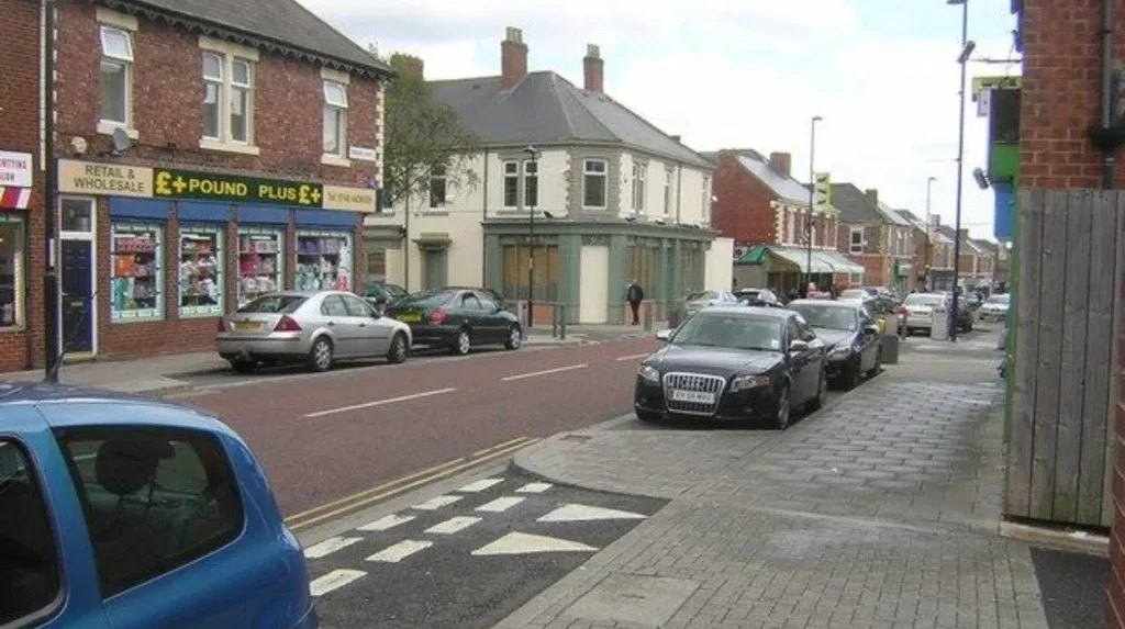
Local shops supplied everyday goods, while schools, religious buildings and community institutions supported household needs. The availability of these services reduced the need for frequent journeys to central commercial districts and encouraged regular contact between residents.
A neighbourhood’s commercial activity depended on its population, street layout and purchasing power. Shops often worked best where pedestrians passed regularly and households needed convenient access to food, clothing, household goods and repairs.
The presence of local services also shaped the identity of residential streets. A neighbourhood was not simply a collection of houses; it was a connected environment in which employment, shopping, education and social life influenced one another.
The precise history of individual Arthur’s Hill shops requires evidence from trade directories, advertisements, census records and historic photographs. These records can identify former businesses and help show how the local economy changed as household needs and transport patterns developed.
How Did Schools and Religious Institutions Shape Community Life?
Schools and religious institutions were important parts of nineteenth-century urban communities. Schools provided education for children, while churches and other places of worship offered religious services and opportunities for social contact. Their reach depended on local provision, household circumstances and the development of public education.
The Elementary Education Act 1870 established a framework for creating school boards in England and Wales where existing educational provision was insufficient. Later legislation expanded compulsory education and changed the relationship between families, schools and the state.
Religious institutions also reflected the diversity of urban communities. Industrial cities attracted people from different parts of Britain and, over time, from overseas. Their institutions contributed to neighbourhood life through worship, charitable activity, education and mutual support.
For Arthur’s Hill, individual school and religious histories should be verified through institutional archives and local records. Such research can establish when a building opened, how its role changed and which populations it served.