

Kenton is an established residential suburb in north-west Newcastle upon Tyne, known for neighbourhood shops, local schools, community facilities and accessible green spaces. Its location near Gosforth, Kingston Park and major road connections supports everyday living and commuting.
- How Did Kenton Newcastle Develop Historically?
- What do historical records reveal about early Kenton?
- How did coal mining influence Kenton’s growth?
- When did Kenton become a residential suburb?
- What Are the Best Things to Do in Kenton Newcastle?
- Why visit North Kenton Park?
- What can visitors explore at Kenton Dene?
- Which nearby attractions are worth visiting?
- Where Can You Shop in Kenton Newcastle?
- What is available at Kenton Retail?
- Where can residents buy groceries and everyday essentials?
- What other shopping destinations are close to Kenton?
- What Is Everyday Life Like in Kenton?
- Which Schools and Community Facilities Serve Kenton?
- Which schools are located in Kenton?
- What services are available at the Kenton Centre?
- Where can residents take part in sport and community activities?
- How Can You Travel Around Kenton Newcastle?
- Which public transport options serve Kenton?
- How accessible is Kenton by car?
- Is Kenton suitable for walking and cycling?
- What Makes Kenton Important to Newcastle’s Wider Community?
- What do population statistics tell us about Kenton?
- How does Kenton’s history influence its modern identity?
- What should residents expect from Kenton’s future development?
- Is Kenton Newcastle a Good Area to Visit or Live In?
Kenton sits within the metropolitan district of Newcastle upon Tyne in Tyne and Wear, North East England. The area functions primarily as a residential neighbourhood rather than a major tourist destination. Its local identity comes from its historical settlement, post-war housing development and community infrastructure.
The name Kenton also identifies an electoral ward used for local government representation. Ward boundaries and the wider neighbourhood’s informal boundaries do not always cover precisely the same area. This distinction matters when comparing demographic statistics, school catchments and local services. Newcastle City Council and the Office for National Statistics provide information through their respective administrative and statistical systems.
Kenton’s geographical position provides access to nearby neighbourhoods, including Gosforth, Fawdon, Cowgate and Kingston Park. Residents use these adjoining areas for additional retail, leisure and transport options. The A1 Western Bypass also connects north-west Newcastle with other parts of Tyneside and routes towards Northumberland.
How Did Kenton Newcastle Develop Historically?
Kenton developed from a medieval settlement into a mining community and, later, a residential suburb of Newcastle. Historical records document the settlement in the twelfth century, while coal mining, quarrying and twentieth-century housing construction shaped its subsequent physical and economic development.
Newcastle City Council’s Historic Environment Record identifies evidence of prehistoric activity around Kenton, including approximately 50 Neolithic flint finds discovered in 1978. Neolithic communities lived thousands of years before the medieval settlement documented in written records. These finds establish a much earlier human presence in the surrounding landscape.
What do historical records reveal about early Kenton?
The first documented historical reference to Kenton dates to the twelfth century. A record associated with William of Newham describes the transfer of Kenton to his daughter. The settlement was connected with the medieval barony of Whalton, and historical evidence records six taxpayers there in 1296. sitelines.
Medieval Kenton was a small settlement rather than the extensive residential suburb seen today. Records also identify a late-thirteenth-century windmill, a manor house and a quarry dating to the fourteenth century. The original settlement’s precise layout remains uncertain, although historical research suggests a compact arrangement of dwellings along intersecting routes.
How did coal mining influence Kenton’s growth?
Coal mining became a major influence on Kenton’s development. The surrounding Newcastle area contained collieries, wagonways and industrial routes used to transport coal from mining sites towards markets and river facilities.
Kenton Colliery supported employment and helped shape the area’s housing patterns. Historical accounts associate early miners’ dwellings with streets including Shiney Row and Low Row. Coal extraction continued into the twentieth century, while former industrial infrastructure appeared on historical Ordnance Survey maps.
Quarrying also contributed to the local economy. Stone from the wider area supplied construction projects, including buildings in Newcastle’s historic Grainger Town district. These industries connected a relatively small settlement with the city’s wider commercial and building economy. sitelines.newcastle.gov.uk+2
When did Kenton become a residential suburb?
Kenton’s transition accelerated as Newcastle expanded and demand for housing increased. By the mid-nineteenth century, miners’ homes had extended the settlement beyond its earlier form, while farming continued around parts of the developing community.
In 1866, Kenton became a separate civil parish. The parish was abolished on 1 April 1935, when Kenton was incorporated into Newcastle upon Tyne. Extensive residential construction continued during the twentieth century, creating housing estates, schools, local shops and public facilities. Newikis+1
The area’s built environment reflects these successive phases. Older housing, interwar residential streets, post-war estates and later developments sit within the same wider suburb. This mixture explains why Kenton’s character varies between North Kenton, Kenton Bar and streets closer to Gosforth.
What Are the Best Things to Do in Kenton Newcastle?
The main things to do in Kenton include walking through North Kenton Park, exploring Kenton Dene, using local sports facilities and visiting neighbourhood shops. Nearby Gosforth, Kingston Park and Newcastle city centre provide additional leisure, shopping and cultural attractions.
Kenton’s attractions focus on everyday recreation rather than large visitor landmarks. The combination of open green space, play facilities, sports venues and community services makes the suburb suitable for short outings and regular leisure activities.
Why visit North Kenton Park?
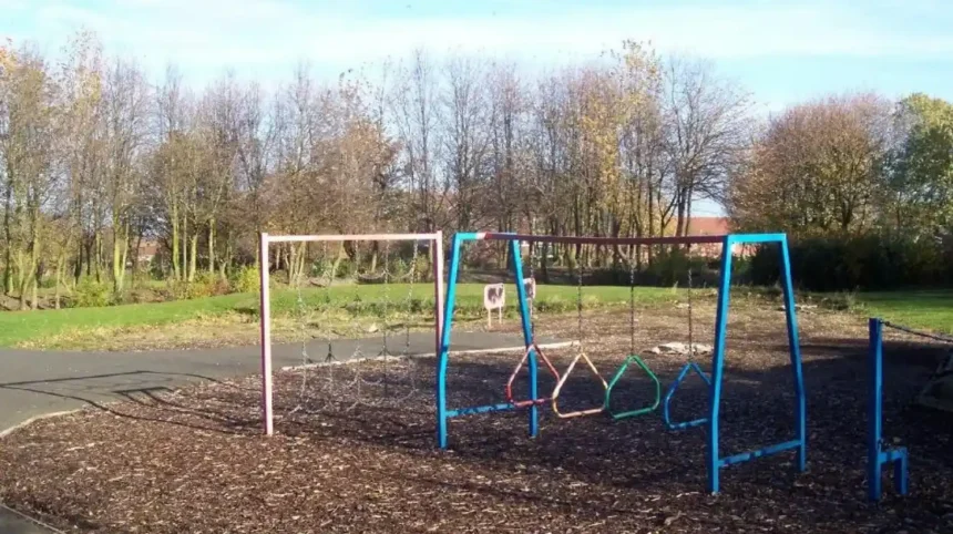
North Kenton Park is a municipal park developed during the mid-twentieth century. It contains open grassland, footpaths, informal recreation areas and a children’s play area. The park provides space for walking, family outings and casual outdoor games. Newcastle City Council
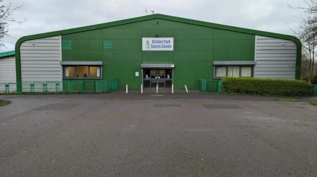
The park also contains Kenton Park Sports Centre, a community leisure facility offering activities for adults and children. Visitors should check the centre’s current programme before travelling, particularly when planning organised classes or children’s activities.
Newcastle City Council identifies accessible paths, a relatively level layout and public toilets within the sports centre. These features support visits with pushchairs and some mobility requirements, although visitors should check individual facility access arrangements if they have specific accessibility needs.
What can visitors explore at Kenton Dene?
Kenton Dene is a green corridor associated with Kenton Lane and the surrounding residential districts. A dene is a local geographical term for a small valley, often containing a stream or wooded landscape. Kenton Dene provides space for walking, informal outdoor recreation and dog walking.
The green space links Kenton’s residential environment with the wider landscape towards the Newcastle Town Moor. Its paths offer an alternative to walking along busy roads, although route conditions vary and visitors should remain on suitable paths where necessary.
Kenton Dene is especially relevant to residents seeking free outdoor activities close to home. A short walk, a dog-walking routine or an informal family outing requires little planning. Visitors should take litter home, respect wildlife and check local signage regarding access and responsible dog control.
Which nearby attractions are worth visiting?
Kenton’s location provides access to several attractions beyond its immediate boundaries.
- Town Moor: A large area of historic common land north of Newcastle city centre, used for walking, running and informal recreation.
- Exhibition Park: An urban park with open space, a lake and access to nearby city-centre attractions.
- Jesmond Dene: A wooded valley with paths, natural features and historic landscape elements.
- Kingston Park: A neighbouring district with substantial retail facilities and a Metro station.
- Newcastle city centre: A destination for historic architecture, museums, theatres, restaurants and larger shopping centres.
These places offer different experiences, from quiet walks to full days of shopping and sightseeing. Journey times depend on the starting point, transport service and traffic conditions.
Where Can You Shop in Kenton Newcastle?
Shopping in Kenton centres on neighbourhood retail parades and Kenton Retail, where residents find convenience stores, food outlets and everyday services. Kingston Park provides additional large-format shopping, while Gosforth and Newcastle city centre offer broader retail choices.
Kenton’s retail network serves routine household needs rather than functioning as a major regional shopping destination. Residents can combine grocery shopping, pharmacy visits, food purchases and personal services within the local area.
What is available at Kenton Retail?
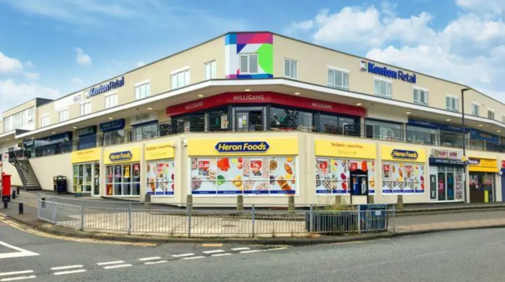
Kenton Retail is a neighbourhood shopping centre in North Kenton. Its development dates to the 1950s, when expanding housing created demand for nearby shops and services. The centre subsequently underwent a refurbishment programme that began in late 2014. kentonretail.co.uk+1
The retail mix has included convenience shopping, pharmacy services, bakeries, takeaway food outlets, hairdressing and postal services. Individual tenants change over time, so visitors should check current listings before making a journey for a particular business.
The centre also offers a practical location for combining shopping with appointments and other errands. Its proximity to the Kenton Centre helps connect retail activity with community services.
Where can residents buy groceries and everyday essentials?
Residents have access to small local shops and convenience outlets around Kenton Lane and the North Kenton shopping area. These businesses support quick purchases without requiring a journey into Newcastle city centre.
For a larger grocery shop, nearby Kingston Park provides additional retail capacity, including a major Tesco Extra store. This neighbouring retail area serves shoppers who need a broader supermarket range or want to combine grocery shopping with other purchases.
The distinction between Kenton and Kingston Park matters when searching for businesses. Some services commonly associated with the wider Kenton area sit just outside the suburb’s boundaries. Checking the full address helps establish whether a shop is within Kenton itself or in a neighbouring district.
What other shopping destinations are close to Kenton?
Gosforth offers another option for everyday shopping, food outlets and personal services. Its high street provides a different retail environment from Kenton’s smaller neighbourhood parades.
Newcastle city centre offers the widest choice for specialist shopping and major retail brands. Eldon Square is a large shopping centre close to central transport connections. Visitors can also explore the surrounding streets and historic commercial district.
Kingston Park, Gosforth and the city centre serve complementary purposes. Kenton residents can complete routine errands locally, visit a neighbouring suburb for a wider choice or travel into central Newcastle for a more extensive shopping trip.
What Is Everyday Life Like in Kenton?
Everyday life in Kenton revolves around residential streets, local shopping, schools, green spaces and community facilities. The suburb contains varied housing types and neighbourhood settings, creating different experiences across North Kenton, Kenton Bar and the streets bordering Gosforth.
Kenton’s residential character reflects its gradual expansion rather than a single planned architectural style. The area includes interwar houses, post-war housing estates, privately owned properties and newer residential developments. This variety influences the appearance of streets and the range of homes available to prospective residents.
What types of homes are found in Kenton?
Traditional residential streets around Kenton Lane include houses dating from the early and middle decades of the twentieth century. Other parts of Kenton contain terraces, flats, bungalows and estate housing associated with later development.
Kenton Bar is particularly associated with a distinctive post-war housing layout. Its development began shortly after 1966, and the estate includes terraced houses, bungalows and flats. Its design incorporated pedestrian routes between many properties, reducing the need to cross roads for certain local journeys.
Housing conditions and prices vary by property size, condition, tenure, location and proximity to local amenities. Buyers and renters should compare individual properties rather than treating Kenton as a uniform housing market.
What should people consider before moving to Kenton?
Prospective residents should assess the practical details that shape everyday life.
First, examine the distance from a property to the shops, schools, green spaces and bus stops used regularly. A home near one shopping parade can offer a different routine from a property closer to Gosforth or the Western Bypass.
Second, check the precise address against school admission arrangements and transport routes. Living within the broad Kenton area does not automatically guarantee admission to a preferred school or provide the most convenient connection to a particular workplace.
Third, inspect parking arrangements, road noise and walking routes at different times of day. Kenton includes residential streets as well as roads carrying local and through traffic. These differences matter to households that rely on walking, cycling or driving.
Which Schools and Community Facilities Serve Kenton?
Kenton has primary and secondary education provision, a public library, healthcare services and community leisure facilities. These services support families and other residents, although school admissions, healthcare registration, opening hours and activity schedules require confirmation directly with the relevant provider.
Education and community infrastructure developed alongside Kenton’s twentieth-century housing expansion. The area now contains facilities for learning, recreation and access to selected public services.
Which schools are located in Kenton?
Kenton School is an academy on Drayton Road, Kenton, with an age range of 11 to 18. Newcastle City Council lists the school as serving secondary-age pupils and sixth-form students. Newcastle City Council
Primary schools associated with the wider Kenton area include Mountfield Primary, Wyndham Primary, Kenton Bar Primary and St Cuthbert’s Roman Catholic Primary. Families should confirm current school names, admission criteria, catchment information and available places before making decisions about a move.
School quality and suitability depend on individual needs. Parents should review the latest Ofsted reports, published performance information, special educational needs provision and the journey between home and school.
What services are available at the Kenton Centre?
Kenton Library is located within the Kenton Centre on Hillsview Avenue. The wider centre has been associated with community services, healthcare provision and local authority housing support.
The library provides access to books, reading resources and other public library services. It also serves as a local community resource for people who want to read, study or access information outside the home.
Opening hours and available activities can change. Residents should consult Newcastle City Council’s current library listing before visiting, particularly when planning a visit outside standard weekday hours.
Healthcare arrangements also require checking. People moving to Kenton should use NHS service directories to identify the appropriate GP practice and confirm whether it accepts new registrations. The presence of a medical facility in the neighbourhood does not guarantee immediate registration or appointment availability.
Where can residents take part in sport and community activities?
North Kenton Park Sports Centre provides a local base for physical activity and organised leisure. Its position within the park allows visitors to combine an indoor activity with time outdoors.
Community sports facilities support different forms of participation, including exercise sessions, children’s activities and organised sport. Availability depends on the venue’s timetable, staffing, booking arrangements and the age group involved.
Residents looking for regular activities should check the current programme before travelling. This is particularly important for people organising children’s parties, joining a class or arranging group sessions.
How Can You Travel Around Kenton Newcastle?
Kenton connects with the wider Newcastle transport network through local bus services, nearby Tyne and Wear Metro stations and major roads. The most convenient option depends on the exact address, destination, service timetable and whether the journey involves walking or changing transport.
Kenton’s position in north-west Newcastle gives it access to routes serving residential districts, shopping areas and the city centre. Road connections also support journeys towards Newcastle International Airport and destinations outside the city.
Which public transport options serve Kenton?
Local bus services connect Kenton and nearby neighbourhoods with destinations across Newcastle. Routes and stopping points vary by street, so passengers should check current timetables rather than assume that every service passes through every part of Kenton.
The Tyne and Wear Metro provides additional connections through nearby stations, including Fawdon, Kingston Park and Bank Foot. These stations serve different surrounding areas, and the nearest station depends on the starting address.
Passengers can consult Nexus for current Metro information and use the relevant bus operator’s timetable for local services. Journey planners are useful when checking evening travel, weekend schedules, accessibility and connections between services.
How accessible is Kenton by car?
The A1 Western Bypass is an important road connection near Kenton. It links Newcastle with routes towards Northumberland and other parts of the regional road network. The surrounding road system also provides access to Newcastle city centre, nearby suburbs and Newcastle International Airport.
Driving convenience depends on traffic conditions and the specific destination. Commuters should assess peak-time congestion and the availability of parking at workplaces or public facilities. Households relying on a car should also check driveway space, residential parking restrictions and access to major roads before choosing a property.
Is Kenton suitable for walking and cycling?
Walking is practical for many short journeys between homes, local shops, schools and green spaces. However, the suitability of a walking route depends on pavement conditions, road crossings, gradients and the distance involved.
North Kenton Park and Kenton Dene provide opportunities for recreational walking away from some busy streets. Cycling can also support local travel, but cyclists should plan routes according to traffic conditions and available infrastructure.
Residents who depend on active travel should test their regular routes in person. A short distance on a map does not always indicate a comfortable or accessible journey, particularly for children, older people or anyone with mobility requirements.
What Makes Kenton Important to Newcastle’s Wider Community?
Kenton contributes to Newcastle’s residential geography by combining housing, local retail, education, recreation and public services. Its historical development from a rural settlement and mining community into a suburban neighbourhood illustrates how Newcastle expanded beyond its historic urban core.
Kenton’s significance lies primarily in its role as a place to live and access everyday services. Its shops support local spending, its schools serve children and young people, and its parks provide space for recreation. Nearby retail and transport connections link the suburb with the wider city.
What do population statistics tell us about Kenton?
Population figures depend on the geographical boundary used. Electoral wards, census statistical areas and informal neighbourhood definitions measure different populations, so their totals should not be treated as interchangeable.
For a broad statistical picture, Census 2021 data provides information about residents, households, age, housing tenure and travel to work. The Office for National Statistics publishes ward-level information and supports comparisons between neighbourhoods and local authorities. Office for National Statistics+1
Kenton’s housing and service patterns reflect a residential population with different household types and needs. Accurate conclusions about the area’s current population, age profile or tenure should come from a clearly identified census geography and reference year.
How does Kenton’s history influence its modern identity?
Kenton’s historical development remains visible in its combination of older settlement routes, mining-era associations, interwar streets and post-war housing. The former relationship between local employment and housing helps explain the area’s growth during Newcastle’s industrial period.
Newcastle City Council’s Historic Environment Record documents archaeological and historical sites associated with Kenton. The council’s wider character assessment also discusses historic routes, coal workings and the evolution of settlements across northern Newcastle.
These records provide a foundation for understanding the area’s built environment. They also help distinguish surviving historic features from later residential development.
What should residents expect from Kenton’s future development?
Kenton’s future residential character depends on housing demand, infrastructure investment, public transport provision, retail changes and the management of green space. These factors affect how easily residents access services and how the suburb accommodates changing household needs.
Newcastle’s planning framework considers the relationship between development, local character, transport and environmental quality. Any specific proposal affecting Kenton should be assessed through the relevant planning application, consultation documents and council decisions rather than assumed from general development trends.
Maintaining accessible parks, supporting local shops and improving walking and cycling connections are important considerations for residential neighbourhoods. These priorities influence daily life as much as major construction projects.
Is Kenton Newcastle a Good Area to Visit or Live In?
Kenton suits people seeking an established Newcastle residential neighbourhood with local shopping, schools, parks and community services. Its practical advantages depend on the exact location, housing requirements, preferred transport options and access to the facilities most important to each household.
For visitors, Kenton offers neighbourhood parks, local shopping and a glimpse of Newcastle’s suburban development. North Kenton Park and Kenton Dene provide straightforward outdoor activities, while Kingston Park and Gosforth expand the range of nearby shopping and leisure options.
For prospective residents, the key considerations are housing suitability, school arrangements, commuting routes, healthcare access and the distance to everyday amenities. Kenton’s varied housing stock means that conditions and convenience differ considerably between individual streets.
The area is best understood as part of Newcastle’s wider residential network rather than as an isolated destination. Its local services support daily routines, while nearby districts provide additional facilities and connections.
Before making a visit or moving decision, check current shop opening hours, transport timetables, school information and council service listings. These checks provide the most reliable picture of Kenton as it stands today.