Benwell is a historic district in the West End of Newcastle upon Tyne, shaped by Roman frontier history, medieval settlement, coal mining, Victorian industrial expansion and twentieth-century housing development. Its modern streets contain archaeological remains, listed buildings, former industrial landscapes and surviving evidence of earlier communities.
- What is Benwell and where is it in Newcastle?
- How did Roman Benwell develop along Hadrian’s Wall?
- What remains of the Roman fort at Benwell today?
- Who was Antenociticus and why is his temple important?
- How did Benwell change during the medieval period?
- When did coal mining become important in Benwell?
- Why did Benwell become an industrial suburb in the nineteenth century?
- What was Victorian Benwell like?
- Why is St James’ Church important to Benwell’s history?
- How did Benwell become part of Newcastle upon Tyne?
- How did twentieth-century housing reshape Benwell?
- Which historic buildings and landscapes survive in Benwell?
- How can researchers study Benwell’s history today?
- How can visitors understand Benwell’s history today?
- Why does Benwell matter to the history of Newcastle?
For anyone studying Newcastle’s development, Benwell provides a compact example of how a rural settlement became an industrial suburb and then a modern urban neighbourhood. Its history connects directly with Hadrian’s Wall, the River Tyne, coal extraction, engineering, transport, housing and municipal expansion.
What is Benwell and where is it in Newcastle?
Benwell is a historic West End district of Newcastle upon Tyne, west of the city centre and close to Scotswood, Elswick and Denton. Its identity developed from a Roman frontier settlement into a coal-mining and industrial suburb before becoming part of Newcastle.
Benwell occupies elevated ground north of the River Tyne. The district sits within the western urban area of Newcastle upon Tyne and forms part of the wider West End.
Its location explains much of its historical development. Benwell stood close to the Roman frontier, above the Tyne and beside routes connecting Newcastle with settlements further west. Later, the same geography supported coal mining, industrial expansion and worker housing.
The historic environment record identifies Benwell as an area with archaeological evidence extending from prehistoric activity through the Roman period, medieval settlement, coal mining and modern urban development. A Neolithic stone axe discovered in 1853 provides evidence of human activity before the Roman occupation.
The name Benwell has a long documentary history. Newcastle’s Historic Environment Record identifies an early reference to “Bynnewalle” dating from about 1050. The settlement was associated with the barony of Bolbec before passing through ecclesiastical and Crown ownership.
Benwell therefore predates the industrial neighbourhood visible today. Its present streets represent several different phases of development rather than one continuous period of urban construction.
How did Roman Benwell develop along Hadrian’s Wall?
Roman Benwell developed around Condercum, a permanent fort on Hadrian’s Wall, with a civilian settlement, religious buildings, roads, military infrastructure and burial activity. Archaeological evidence makes Roman Benwell one of Newcastle’s most important frontier landscapes.
Hadrian’s Wall was constructed from AD 122 after the visit of Emperor Hadrian to Britain. The frontier eventually extended for about 73 miles, from Bowness-on-Solway in Cumbria to Wallsend on the River Tyne.
Benwell formed part of Wall Mile 6. The Roman fort at Benwell was known as Condercum. It was one of the permanent forts established along the frontier and was occupied through much of the Roman period.
English Heritage identifies the cavalry regiment ala I Asturum as the principal military unit associated with the fort. An ala was a Roman auxiliary cavalry unit rather than one of the citizen legions.
The fort was not an isolated military installation. A civilian settlement, known as a vicus, developed outside it. Such settlements supplied services, accommodation, trade and other activities connected with the military population.
Archaeological evidence indicates that Benwell’s vicus was substantial. Excavations recorded buildings around the road running south from the fort, including a mansio. A mansio was an official stopping place used by travellers and officials moving through the Roman road network.
This evidence changes the way Benwell’s history can be understood. Roman Benwell was not simply a defensive wall and fort. It was a settlement containing military, civilian, commercial and religious functions.
What remains of the Roman fort at Benwell today?
The main Roman fort at Benwell is largely hidden beneath later development, but its archaeological footprint survives as a protected Scheduled Monument. The surviving Roman landscape also includes the Temple of Antenociticus and an important crossing over the Vallum.
Modern development has covered substantial parts of Condercum. English Heritage records that the northern part of the fort was affected by the construction of a Victorian reservoir, while housing covers other parts of the archaeological site.
Historic England records the Hadrian’s Wall and Condercum fort remains as a Scheduled Monument under the Ancient Monuments and Archaeological Areas Act 1979.
The designation reflects the national importance of the archaeological remains even where they are not visible above ground.
The destruction and concealment of archaeological remains also form part of Benwell’s modern history. Urban expansion placed roads, reservoirs and houses over sections of the Roman landscape.
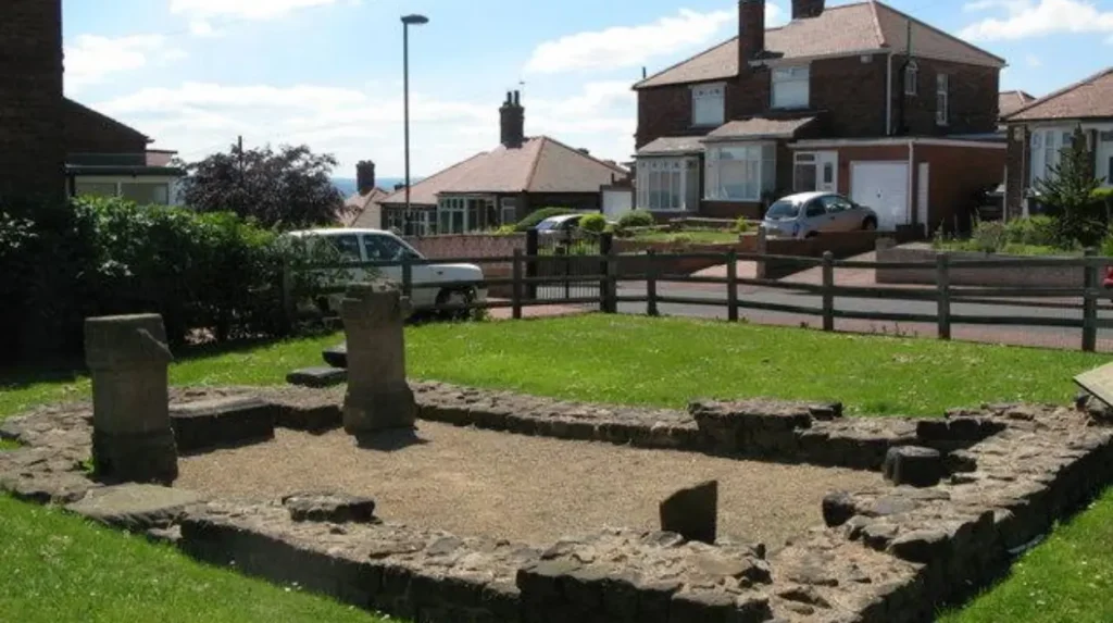
A particularly important survival is the Roman Temple of Antenociticus. The temple stood east of the fort within the civilian settlement. It provides visible evidence of the religious life associated with Roman Benwell.
The Vallum crossing provides another significant survival. The Vallum was a major earthwork running south of Hadrian’s Wall. At Benwell, a stone-built causeway crossed the earthwork, linking the southern approach with the fort.
These remains demonstrate how military infrastructure extended beyond the Wall itself. The frontier operated as a connected system of forts, roads, earthworks, settlements and religious sites.
Who was Antenociticus and why is his temple important?
Antenociticus was a local deity worshipped at a Roman temple in Benwell. The site is important because inscriptions and sculpture provide rare archaeological evidence for a named Celtic god and show how local religious traditions existed within Roman frontier society.
The Temple of Antenociticus was constructed by about AD 178–180. One altar inscription records a dedication by Tineius Longus, a Roman cavalry prefect associated with the fort.
The temple produced three altars and a sculptured head identified with Antenociticus. The head was discovered in 1862. Fragments of a forearm and lower leg were also found, indicating that the original sculpture was probably part of a life-sized statue.
The deity is particularly significant because named Celtic gods are comparatively uncommon in the surviving archaeological record of Roman Britain.
The temple therefore illustrates cultural interaction along Hadrian’s Wall. Roman military occupation did not remove every local religious tradition. Instead, archaeological evidence shows a religious landscape in which a local deity received formal worship within a Roman frontier settlement.
The three altars and sculptured head are now held by the Great North Museum: Hancock in Newcastle. The surviving material provides an important research resource for historians and archaeologists studying Roman religion.
The temple is also significant because it represents the visible remains of Benwell’s former civilian settlement. Much of the vicus has disappeared beneath later development, making the surviving temple especially valuable for understanding the Roman community.
How did Benwell change during the medieval period?
Medieval Benwell remained a rural settlement organised around its manor, fields and agricultural economy. Documentary evidence records the village from about 1050, while later ownership connected Benwell with the barony of Bolbec, Tynemouth Priory and the Crown.
The early medieval period followed the end of Roman administration in Britain during the early fifth century. Archaeological evidence from Benwell includes Anglo-Saxon material, including brooches discovered west of the Roman temple.
The medieval settlement developed around a village structure rather than an industrial town. Newcastle’s Historic Environment Record describes Benwell as originally having two rows of houses separated by a wide street or possible village green extending west from the manor house.
The historic street pattern survives in places through Benwell Village, Benwell Lane, Ferguson’s Lane and Fox and Hounds Lane.
Tynemouth Priory became an important landowner. In the mid-15th century, Robert Rodes gave the manor of Benwell to the priory. Following the Dissolution of the Monasteries under Henry VIII, the property passed to the Crown.
Benwell subsequently became divided between private estates. By the early modern period, coal extraction was becoming increasingly important.
The medieval landscape therefore provided the framework for later change. Roads, property boundaries and settlement patterns established before industrialisation influenced the shape of the neighbourhood that developed during the eighteenth and nineteenth centuries.
When did coal mining become important in Benwell?
Coal mining became a defining part of Benwell’s economy over several centuries. Documentary evidence records local coal workings from at least the medieval period, while larger-scale extraction expanded during the eighteenth and nineteenth centuries as Newcastle’s industrial economy grew.
The Historic Environment Record records coal mining in the Benwell area from at least the fourteenth and sixteenth centuries. Records from 1375–76 refer to coal mines in the park at Scotswood, while sixteenth-century documents identify workings in Westmore and Eastfield.
Coal became increasingly important because Benwell contained accessible seams close to the Tyne. The steep riverbanks and geological conditions supported extraction before deep mining technology developed.
By the eighteenth century, coal mining had become a major influence on the district. Benwell Colliery formed part of this wider mining landscape.
Mining altered both employment and land use. Fields were increasingly associated with pits, transport routes, workers and industrial infrastructure.
The relationship between coal and Newcastle was regional rather than isolated. Newcastle’s position on the Tyne allowed coal from the wider coalfield to move towards markets and shipping facilities.
Benwell’s location between the city and riverside industrial districts placed it close to this economic network.
The coal industry also influenced social geography. Mine owners, engineers and merchants could occupy substantial houses, while mining workers lived in more modest housing close to employment.
That contrast became more pronounced as Benwell moved from rural settlement to industrial suburb.
Why did Benwell become an industrial suburb in the nineteenth century?
Benwell became an industrial suburb because expanding coal mining, engineering and riverside manufacturing created employment and attracted workers. New roads, housing, churches and public infrastructure followed, transforming farmland and estates into a densely settled urban district.
The nineteenth century produced the most dramatic physical transformation in Benwell’s history.
Newcastle’s industrial expansion centred heavily on the River Tyne. Coal, iron, engineering, shipbuilding and associated industries created employment across the western suburbs.
The Armstrong engineering works, established in 1847 at Elswick, became a major industrial employer in the wider West End. The growth of engineering and heavy industry increased demand for housing.
Academic research on Benwell describes the late nineteenth-century development of large areas of private rented terraced housing for the expanding workforce. This housing transformed the grassy slopes above the Tyne into an urban landscape.
The industrial transformation also changed the social composition of the district. Workers moved into newly constructed terraces, while industrialists and wealthy professionals occupied larger detached houses and estates.
This produced a distinctive landscape containing workers’ streets, industrial infrastructure, churches, schools, mansions and public buildings within a relatively compact area.
By the late nineteenth century, Benwell had become part of a much larger urban system centred on Newcastle and the Tyne.
What was Victorian Benwell like?
Victorian Benwell combined dense workers’ housing with churches, schools, industrial facilities and substantial private estates. Its architecture reflected rapid population growth, industrial wealth and the social divisions created by Newcastle’s expanding nineteenth-century economy.
The transformation can be measured through population evidence. A historical account published in 1848 recorded 2,415 inhabitants across the district, including 1,433 within the township of Benwell.
Later growth was much faster. By the 1911 Census, Benwell Civil Parish had a population of 27,049.
This increase demonstrates the scale of urbanisation between the mid-nineteenth and early twentieth centuries.
Terraced housing became one of the defining features of the expanding district. Developers constructed streets for workers employed in nearby engineering works, coal mines and other businesses.
At the same time, large houses remained part of the landscape. Benwell House, Benwell Hall, Condercum House, Pendower and other estates represented the wealth of industrial and commercial families.
Several of these houses have since disappeared.
Condercum House was an 1860s mansion associated with figures connected to the Armstrong Works and local commercial life. It was demolished in 1937 for residential redevelopment.
Benwell Hall survived longer. The house had associations with merchants and industrial families before being demolished in 1982.
The disappearance of these buildings demonstrates how twentieth-century redevelopment altered the physical evidence of Victorian Benwell.
Why is St James’ Church important to Benwell’s history?
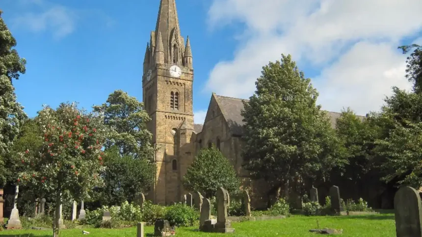
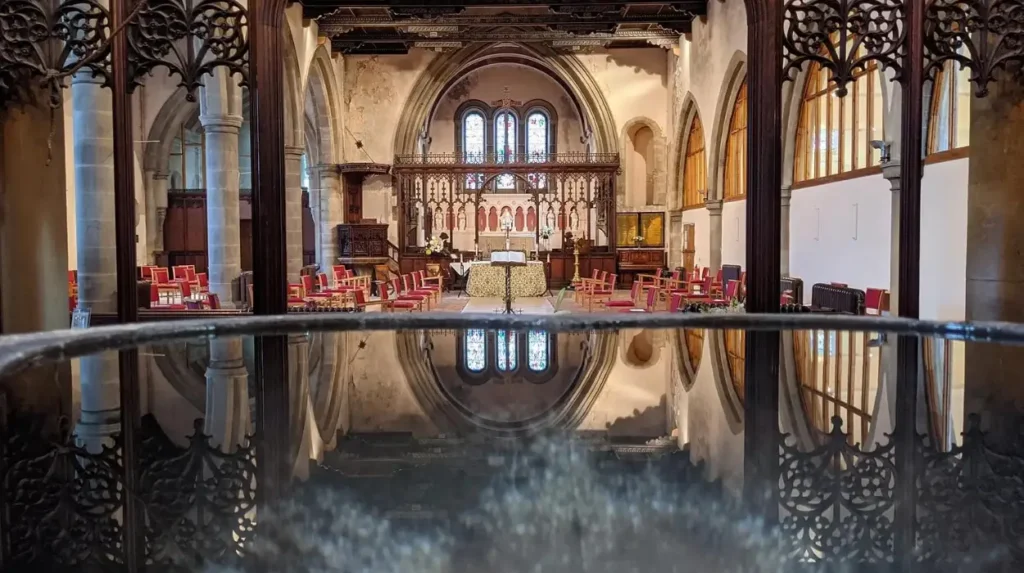
St James’ Church is one of Benwell’s most important surviving nineteenth-century buildings. Designed by Newcastle architect John Dobson, it opened in 1833, became a parish church in 1843 and expanded repeatedly as Benwell’s population increased.
St James’ Church was created when Benwell was still largely rural. It opened as a Chapel of Ease serving residents who lived beyond the convenient reach of St John’s Church in central Newcastle.
John Dobson designed the building. Dobson was a leading nineteenth-century Newcastle architect whose work included important civic and commercial buildings in the city.
John Buddle, a prominent mining engineer and colliery manager, donated the land for the church. He is buried in the churchyard.
The building expanded as the local population grew. The nave and aisle were added in 1864. An organ chamber and vestry followed in 1879–80. A spire, choir vestry and porch were added in 1895.
Historic England lists St James’ Church at Grade II. The listing recognises its architectural and historic interest.
The churchyard also contains the graves of people connected with Newcastle’s industrial and civic history. William Maughan, the first vicar of St James’, served from 1843 to 1877.
For genealogical research, the church is particularly useful. Tyne & Wear Archives holds microfilm copies of St James’ baptismal records from 1832–1958, marriage records from 1844–1958 and burial records from 1833–1966.
How did Benwell become part of Newcastle upon Tyne?
Benwell was incorporated into Newcastle upon Tyne in November 1904 after operating within its own urban district structure. The boundary change reflected the physical growth of Newcastle and the integration of formerly separate industrial suburbs into the expanding city.
Benwell was not always part of Newcastle.
During the nineteenth century, the district developed its own administrative structures as population and urban development increased. Benwell Civil Parish was formed in 1866 following changes associated with the Poor Law system.
Benwell and Fenham later operated as an urban district. The growing built-up area increasingly connected Benwell with neighbouring parts of Newcastle.
On 9 November 1904, Benwell and Fenham Urban District was absorbed into Newcastle upon Tyne. Walker Urban District was also incorporated during the same boundary expansion.
This change represented more than an administrative adjustment. Newcastle had become an industrial city whose employment, housing, transport and public services crossed older parish and township boundaries.
The incorporation brought Benwell further into the city’s municipal framework.
The wider process continued during the twentieth century. Newcastle expanded its boundaries again in later decades, while the 1974 local government reorganisation created the modern metropolitan borough structure.
For historical researchers, these administrative changes matter because records can be organised under different jurisdictions depending on the date being investigated.
How did twentieth-century housing reshape Benwell?
Twentieth-century housing programmes replaced parts of the nineteenth-century urban landscape with council estates, planned housing and redevelopment. The Pendower Estate provides a documented example of municipal planning, Garden Suburb principles and post-1919 housing policy.
The First World War left Britain with severe housing pressures. Government legislation encouraged local authorities to construct council housing.
Newcastle Corporation purchased the 60-acre Pendower Estate in 1919 for £37,500. The council intended to use 45 acres for housing and retained land for educational purposes.
The development followed principles associated with the Tudor Walters housing standards and Garden Suburb planning. The initial density was about 12–14 houses per acre, compared with more than 20 houses per acre in some other parts of Benwell.
The first tenants moved into the estate at the end of 1922.
By 1931, the Pendower Estate contained 589 council houses. Much of the construction occurred between 1925 and 1928.
This was a major change from the dense Victorian terraces.
Municipal housing introduced planned streets, gardens and lower residential densities. It also changed the social geography of the district.
The estate demonstrates how national housing legislation affected individual Newcastle neighbourhoods. The Housing, Town Planning, etc. Act 1919, commonly known as the Addison Act, provided the legislative framework for the first phase.
Later development was supported by the 1924 Housing (Financial Provisions) Act, commonly called the Wheatley Act.
Which historic buildings and landscapes survive in Benwell?
Benwell retains Roman archaeological monuments, St James’ Church, historic street patterns, surviving estate features and fragments of older buildings. These remnants provide physical evidence for different stages of the district’s development despite extensive twentieth-century clearance.
The most important Roman survival is the Temple of Antenociticus. The nearby Vallum crossing also remains an important part of the frontier landscape.
St James’ Church survives as a major nineteenth-century architectural landmark.
Historic street patterns provide another layer of evidence. Benwell Village, Benwell Lane, Ferguson’s Lane and Fox and Hounds Lane reflect the earlier settlement structure.
Some historic houses have survived in altered form, while others disappeared during redevelopment.
Pendower Cottages provide an example of surviving estate architecture. Historic Environment Record research identifies cottages associated with the Pendower Estate that remain on Fox and Hounds Lane.
The wider landscape also retains evidence through street names and archaeological remains. Durham University research into Benwell’s community history notes that repeated industrial decline, demolition and redevelopment removed substantial portions of the earlier landscape while leaving evidence in street patterns and surviving structures.
This makes Benwell particularly relevant to urban archaeology. The historical record does not depend solely on complete buildings. Archaeological deposits, property boundaries, road alignments, churches, graveyards and fragments of estates all contribute evidence.
How can researchers study Benwell’s history today?
Researchers can study Benwell through archaeological records, historic maps, parish registers, census returns, architectural surveys, municipal documents and museum collections. These sources allow local, family and industrial histories to be reconstructed across different periods.
The Tyne and Wear Historic Environment Record is an important starting point for archaeological research. It contains records covering Roman remains, medieval settlement, coal mines, houses, churches and twentieth-century estates.
Parish records provide another major source.
Tyne & Wear Archives holds microfilm copies of St James’ baptism, marriage and burial registers. These records support genealogical research into families who lived in Benwell during the nineteenth and twentieth centuries.
Census returns provide population and household information. They can show occupations, addresses, family structures and changes in residential patterns.
Historic Ordnance Survey maps are particularly useful for tracking physical change. They show how fields, pits, houses, roads and industrial sites changed over time.
Museum collections provide material evidence. The Great North Museum: Hancock holds the Roman altars and sculptured head associated with the Temple of Antenociticus.
For researchers tracing family history, the combination of parish registers, census material and maps is particularly valuable. A street address can connect a household record with the physical development of the neighbourhood.
How can visitors understand Benwell’s history today?
Visitors can understand Benwell by combining its Roman monuments, listed architecture, historic streets and surviving housing estates into one chronological landscape. The district works best as an urban heritage study rather than as a single-period historic attraction.
Benwell’s history is distributed across the neighbourhood rather than concentrated in one museum or preserved historic centre.
The Roman Temple of Antenociticus provides the clearest visible connection with the frontier period. English Heritage manages the monument as a free historic site accessible during reasonable daylight hours.
St James’ Church represents the nineteenth-century transformation of the district. Its architecture, churchyard and memorials connect religious history with coal mining, engineering and civic development.
The surviving Pendower Estate provides evidence of interwar municipal housing policy.
Historic streets add another layer. Their alignments demonstrate how a rural village was transformed into an industrial suburb and later reshaped through municipal planning.
To experience this historic West End landscape in person today, consult our comprehensive for itineraries and visiting parameters.
The combination of sites makes Benwell useful for educational visits. A single area contains evidence from Roman frontier archaeology, medieval landholding, coal mining, Victorian industrialisation and twentieth-century housing policy.
Why does Benwell matter to the history of Newcastle?
Benwell matters because its archaeological and architectural evidence records Newcastle’s transformation from Roman frontier territory and rural settlement into an industrial city district. Its surviving monuments demonstrate how military, economic, social and municipal forces reshaped one place over centuries.
Benwell’s significance comes from continuity and change.
The Roman fort established the area within the frontier system of northern Britain. The civilian settlement demonstrates that military sites supported wider communities.
Medieval Benwell developed as a rural manor and village. Coal extraction then connected the district to the long economic history of the Tyne coalfield.
The nineteenth century transformed the landscape again. Engineering and industrial expansion created employment, encouraged population growth and generated extensive private housing.
The population increase between 1848 and 1911 demonstrates the scale of this transformation. Benwell went from a relatively small rural township to a densely populated urban district.
Twentieth-century housing policy created another layer. Pendower shows how municipal planning responded to housing shortages and changing ideas about residential standards.
The surviving archaeological monuments and listed buildings now provide evidence for these transitions.
Benwell therefore functions as a historical cross-section of Newcastle. Roman military power, medieval landholding, coal mining, industrial capitalism, religious institutions, municipal government and housing policy are all represented within the same district.
For historians, students, heritage researchers and genealogists, that density of evidence makes Benwell especially valuable. Its history is not confined to a single landmark. It is embedded in the streets, buildings, archaeological remains, archives and surviving landscape of Newcastle’s West End.