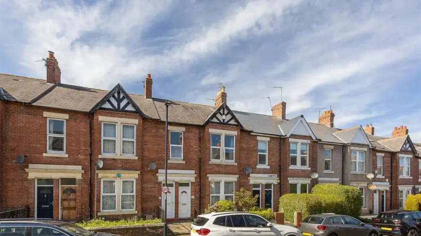
South Gosforth and Dene is an urban area of Newcastle upon Tyne shaped by medieval settlement, nineteenth-century suburban growth, coal mining, railway expansion, public parks, and Metro connections. Its pubs, cafés, churches, streets, and green spaces preserve these historical layers today.
- What is the historical background of South Gosforth and Dene?
- Which historical landmarks explain South Gosforth’s character?
- Which pubs have the strongest historical connections?
- How did Gosforth High Street influence local pubs and cafes?
- Which cafes connect visitors with the modern character of South Gosforth?
- Why is Jesmond Dene important to the history of the Dene area?
- What does South Gosforth railway history reveal about suburban growth?
- Which parks and green spaces are historically significant?
- How are historic pubs, parks and buildings preserved today?
- What can visitors learn from South Gosforth and Dene today?
- Why does the history of South Gosforth and Dene remain relevant?
What is the historical background of South Gosforth and Dene?
South Gosforth developed from a rural and agricultural landscape into a residential suburb during the nineteenth century, while Dene landscapes retained woodland and industrial features. Gosforth High Street became the commercial focus, and South Gosforth developed around Church Road, transport routes, and mining.
The modern Dene and South Gosforth Ward is a contemporary administrative area of Newcastle upon Tyne. Newcastle City Council lists Dene and South Gosforth among the city’s electoral wards, while the current boundaries reflect modern local-government organisation rather than the historic boundaries of Gosforth parish or township.
The historical landscape is older than the present ward structure. Gosforth developed from several settlements and estates, including Coxlodge Hall and Bulman Village. Newcastle’s Historic Environment Record identifies the Gosforth Conservation Area as a settlement containing High Victorian, Queen Anne Revival and Edwardian architecture. The conservation area was designated in April 2002.
South Gosforth followed a somewhat different pattern. Development concentrated around St Nicholas Church, Gosforth Colliery and transport infrastructure. The area therefore combined established religious institutions with industrial employment and later residential growth.
The nineteenth century transformed the district. Newcastle expanded beyond its historic core as improved roads and railways made suburban residence more practical. New terraces, villas, shops, public houses and institutional buildings appeared along established routes.
This process created the physical setting that visitors encounter today. Older buildings survive beside twentieth-century redevelopment, while modern cafés and pubs occupy commercial premises within a landscape established during the Victorian and Edwardian periods.
Gosforth High Street provides an important comparison. Newcastle City Council’s conservation documentation identifies the High Street as the historic core of the conservation area and records its connection with the former Great North Road between London and Edinburgh.
The area’s history therefore cannot be reduced to one building or one industry. Its character developed through the interaction of roads, railways, churches, mining, housing, retailing, hospitality and designed landscapes.
For historical researchers, this layered development is significant because surviving buildings reveal how Newcastle’s northern suburbs changed from rural settlements into integrated urban communities.
Which historical landmarks explain South Gosforth’s character?
The key historical landmarks include St Nicholas Church, South Gosforth Metro station, surviving Victorian housing, historic public houses, and nearby Jesmond Dene. Together, these structures document religious continuity, industrial change, transport development, suburban expansion, and the creation of public landscapes.
St Nicholas Church on Church Road is one of South Gosforth’s most important historic structures. The present church was built in 1799 by John Dodds after the earlier building was demolished. John Dobson, a leading Newcastle architect, extended and modified it in 1820. Later alterations followed in the twentieth century. The building is Grade II listed.
The church demonstrates the continuity of settlement before suburbanisation. Its site represents an older community structure that existed before the arrival of Victorian railways and large-scale residential development.
South Gosforth Metro station provides another major historical reference point. The station opened as Gosforth on 27 June 1864 on the Blyth and Tyne Railway. It was renamed South Gosforth on 1 March 1905.
The railway changed the area’s relationship with Newcastle. Regular transport encouraged commuting, residential construction and commercial growth. The station therefore represents more than transport history. It forms part of the mechanism through which rural and semi-rural land became suburban territory.
The surviving railway footbridge is particularly important. Newcastle’s Historic Environment Record states that the Metro station replaced the earlier railway station and that the sturdy cast-iron footbridge from the nineteenth-century station survives.
Historic housing provides another layer. Gosforth’s conservation area contains examples of High Victorian, Queen Anne Revival and Edwardian architecture. These styles reflect different phases of suburban development and changing architectural preferences between the mid-nineteenth and early twentieth centuries.
Historic public houses also function as architectural evidence. Newcastle City Council’s Gosforth Conservation Area Character Statement identifies several older public houses, including the County, Brandling Arms, Earl Grey, Queen Victoria, now known as Ye Olde Jockey, and Gosforth Hotel. The document notes their contribution to the conservation area’s character.
Together, these landmarks create a historical sequence. The church represents earlier religious settlement. The railway represents industrial-era mobility. Victorian houses represent suburban expansion. Pubs represent commercial and social activity. Parks represent changing ideas about recreation, landscape design and public access.
Which pubs have the strongest historical connections?
South Gosforth’s historic pubs developed alongside roads, mining communities, railways, and expanding suburbs. The Victory and Brandling Villa represent different phases of public-house architecture and social history, while Gosforth High Street preserves older licensed premises associated with the nineteenth-century Great North Road.
The public house became an important institution in nineteenth-century Newcastle communities. Pubs provided licensed accommodation, food, drink and meeting spaces while serving populations associated with industrial employment, transport and growing residential districts.
The Victory on Killingworth Road is particularly relevant to South Gosforth’s industrial history. Local historical research records a pub on the site from the nineteenth century and associates the establishment with the local mining community. A local history source dates its service as a pub to 1861.
Its historical setting is important. South Gosforth developed around industrial and transport activity, and the presence of a long-established public house illustrates how commercial services followed local employment and residential growth.
The Brandling Villa provides another architectural example. Newcastle’s Historic Environment Record states that the building was constructed between 1900 and 1903 for W. B. Reid and Company to designs by architect Arthur Stockwell. A public house had occupied the site since at least the 1880s.
The surviving two-storey sandstone building has prominent bay windows, substantial door surrounds, pilasters and decorative architectural features. Its Local List status recognises its local architectural and historic interest.
The contrast between the Victory and Brandling Villa is useful for understanding change. One connects strongly with the nineteenth-century South Gosforth community and mining environment. The other represents early twentieth-century pub architecture associated with a more established suburban district.
On Gosforth High Street, The Brandling Arms has a much earlier historical association. Newcastle’s Historic Environment Record identifies the building as dating from around 1830, while the conservation-area record identifies the Brandling Arms among the historic public houses that contribute to the character of the High Street.
The County is another surviving High Street pub associated with this historic commercial environment. The concentration of older licensed premises demonstrates that hospitality was embedded in the development of Gosforth as a roadside and suburban centre.
These pubs should therefore be understood as historic buildings and social institutions rather than simply places to eat or drink. Their locations record the relationship between transport routes, employment, population growth and commercial services.
How did Gosforth High Street influence local pubs and cafes?
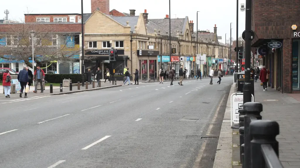
Gosforth High Street became a major commercial route because it formed part of the Great North Road between London and Edinburgh. Its roadside position encouraged inns, public houses, shops and services, while later suburban growth transformed the route into a local commercial centre.
The Great North Road connected London and Edinburgh and passed directly through Gosforth. Newcastle City Council’s conservation documentation identifies this historic route as a defining element of the High Street.
Road traffic created demand for accommodation and refreshment. Public houses developed within this transport environment and subsequently became embedded within the expanding residential community.
The 1820s were significant for the development of the modern High Street. Newcastle’s Historic Environment Record identifies early buildings and the development of Bulman Village. The Brandling Arms was built by approximately 1830, while the earliest surviving buildings include Ye Olde Jockey and a row of six houses dating from 1825.
The architectural fabric demonstrates gradual urbanisation. Sandstone houses, terraces, commercial premises and public houses replaced the appearance of a predominantly rural settlement.
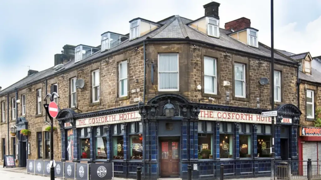
The Gosforth Hotel provides a clear example. The building at 205 High Street was constructed in 1878. A buffet bar was added in 1891, the property was acquired by Arthur’s Hill Brewery in 1900, and its distinctive tiled façade was added in 1913.
The building remains on Newcastle’s Local List because of its local architectural and historic interest. Its history records the changing relationship between brewing companies, hospitality businesses and suburban customers.
Modern cafés continue the commercial function of the High Street, although their business models differ from those of Victorian inns and breweries. Contemporary cafés serve commuters, residents, shoppers and visitors within a commercial environment shaped by more than two centuries of development.
The present-day food and drink scene therefore forms part of a longer commercial tradition. A visitor walking through Gosforth encounters modern businesses within streets whose layout and surviving buildings reflect nineteenth-century economic change.
For visitors interested in the wider historical context, consult our comprehensive for itineraries and visiting parameters.
Which cafes connect visitors with the modern character of South Gosforth?
Modern cafés form part of South Gosforth’s changing commercial landscape, but their historical importance lies in continuity of local high-street activity. Food and drink businesses occupy streets shaped by Victorian expansion, railway access, suburban retailing, and later redevelopment rather than isolated heritage sites.
South Gosforth’s present café culture is concentrated around established commercial streets and transport connections. The modern pattern differs from the nineteenth-century economy, but the underlying principle remains similar: businesses locate where residents, workers and visitors move through the district.
Alan The B operates on Station Road, close to South Gosforth’s railway and Metro history. Its location illustrates the continuing relationship between hospitality and transport infrastructure.
Thyme Square Cafe is another current Station Road food-and-drink business. Station Road itself provides a useful historical setting because South Gosforth station has operated as a transport node since 1864.
On Gosforth High Street, Cafe Beam occupies the Old Fire Station building at 234–236 High Street. The location demonstrates how historic or established buildings can acquire new commercial functions as neighbourhood economies change.
Say When Gosforth and Tremolo Lounge represent the contemporary hospitality economy around the High Street.
The historical significance of these businesses does not depend on claiming that their individual interiors are heritage assets. Their relevance comes from the continuity of commercial activity in a district where streets have supported shops, inns, public houses and services across different periods.
For cultural tourists and students, cafés also provide practical points from which to study the surrounding streetscape. The buildings, road alignments, shopfronts and nearby transport infrastructure provide more historical information than the modern business names alone.
This distinction is important for accurate heritage writing. A contemporary café is not automatically a historic site. Its value in a historical itinerary comes from its position within a landscape shaped by documented urban development.
Why is Jesmond Dene important to the history of the Dene area?
Jesmond Dene provides the strongest historic landscape connection near South Gosforth and Dene. William Armstrong transformed the Ouseburn valley into designed pleasure grounds during the nineteenth century, then transferred the park to Newcastle Corporation, creating a major public heritage landscape.
Jesmond Dene occupies a steep-sided valley associated with the Ouseburn. Newcastle City Council describes it as ancient woodland with geological, ecological and industrial features. The river once powered mills, leaving evidence of industrial activity within the modern landscape.
The nineteenth century produced the landscape visible today. William Armstrong, later Lord Armstrong, acquired much of Jesmond Dene and developed it as private pleasure grounds. Newcastle City Council records that Armstrong had purchased most of the Dene by 1862 and developed features including waterfalls, a grotto and extensive planting.
Historic England’s National Heritage List records Jesmond Dene and the connected parkland as a Grade II registered park and garden. The register identifies nineteenth-century pleasure grounds along the Ouse Burn and records the earlier presence of fields, coal pits and water mills.
The sequence demonstrates a major change in land use. Industrial water power and rural land use preceded Armstrong’s landscape design. Private pleasure grounds followed. Public ownership and recreation then became the dominant function.
Armstrong gave Jesmond Dene to Newcastle Corporation in 1883, and the park was opened to the public in 1884. The transition converted a private landscape into a major civic recreational asset.
The Banqueting House adds architectural significance. Historic England records that the building was constructed between 1860 and 1862 to designs by John Dobson for William Armstrong. It was intended for entertaining guests and formed part of Armstrong’s wider landscape scheme.
Armstrong Bridge is another major surviving feature. Newcastle Heritage records a span of 168 metres and construction at Armstrong’s Elswick Works, linking the engineering history of Newcastle with the designed landscape of Jesmond Dene.
The park therefore connects natural history, industrial archaeology, architecture and public recreation. It is especially valuable for educational visits because the physical landscape demonstrates several historical processes within one location.
What does South Gosforth railway history reveal about suburban growth?
South Gosforth’s railway history began in 1864, when Gosforth station opened on the Blyth and Tyne Railway. Renamed South Gosforth in 1905, it later became part of the Tyne and Wear Metro, preserving an original railway footbridge from the Victorian period.
The Blyth and Tyne Railway opened Gosforth station on 27 June 1864. The station was subsequently absorbed into the North Eastern Railway in 1874. Its railway role expanded as connections between Newcastle, the coast and northern districts developed.
The station’s name changed in 1905. Gosforth became South Gosforth following the opening of West Gosforth station on the Gosforth and Ponteland Light Railway. The renaming created clearer geographical distinctions between the railway stations serving the wider Gosforth area.
Railway electrification added another important stage. Electric services began on sections of the Tyneside system in 1904, and the network subsequently developed into a circular service connecting Newcastle with coastal communities.
The railway supported suburbanisation by reducing the practical distance between residential districts and Newcastle’s central employment areas. This encouraged the construction of villas, terraces and other housing around transport corridors.
The original railway system eventually declined. South Gosforth station closed on 23 January 1978 for conversion to the Tyne and Wear Metro. It reopened on 11 August 1980 as part of the new system.
Most of the original station buildings were demolished during conversion. The cast-iron footbridge survived and remains a physical link with the Victorian railway station. Newcastle’s Historic Environment Record specifically identifies the footbridge as surviving nineteenth-century railway fabric.
This survival demonstrates how infrastructure can retain historical meaning after its original function changes. The station remains a transport facility, but its footbridge also serves as an archaeological and architectural remnant.
For genealogical researchers, railway development provides useful historical context. Families who moved into Gosforth during the late nineteenth and early twentieth centuries often lived within a settlement increasingly connected to Newcastle and surrounding industrial communities.
Which parks and green spaces are historically significant?
The area’s historically significant green spaces include Jesmond Dene, Armstrong Park and Gosforth Central Park, each representing a different phase of landscape development. Their histories range from nineteenth-century private pleasure grounds and civic gifts to twentieth-century municipal recreation and organised community use.
Jesmond Dene represents nineteenth-century landscape design and the transition from private estate to public park. Armstrong’s transformation of the Ouseburn valley created a carefully designed environment containing woodland, water features, bridges, buildings and planted areas.
Armstrong Park forms part of the connected Ouseburn parkland system. Newcastle City Council records that Lord Armstrong gifted the park to Newcastle in 1878 and that it opened in 1879. The park contains mature woodland, steep valleys, grassland and historic features.
The park also contains evidence of earlier industrial activity. Newcastle City Council records a restored post-medieval watermill and other historic features. The combination of woodland and industrial remains demonstrates the layered history of the Ouseburn valley.
Gosforth Central Park belongs to a later period. Newcastle’s Historic Environment Record states that the three-hectare park was created in 1932 at a cost of £10,000 and retains much of its original design.
The park developed from land previously associated with Sanderson Nursery. It opened on 6 August 1932 and subsequently gained bowling greens and play facilities. The south bowling green opened in 1934, while play facilities were introduced in 1937.
These dates demonstrate the changing role of public recreation. Nineteenth-century parks often reflected philanthropy, landscape design and civic improvement. Twentieth-century parks increasingly incorporated organised sports, children’s facilities and everyday neighbourhood recreation.
The surviving park landscapes are therefore historical documents. Their paths, boundaries, mature trees, memorials, buildings and recreational facilities reveal changing approaches to public space.
How are historic pubs, parks and buildings preserved today?
Heritage preservation in South Gosforth relies on listed buildings, local listing, conservation-area controls, historic-environment records, surviving structures, and continued community use. These mechanisms protect architectural evidence while allowing pubs, transport facilities, parks, churches, and commercial premises to serve modern needs.
Historic England provides statutory protection for nationally significant listed buildings and registered parks. The National Heritage List includes protected assets associated with the wider Gosforth and Jesmond Dene landscape.
Local listing provides another layer. Newcastle’s Historic Environment Record identifies locally important buildings and structures, including the Gosforth Hotel and Brandling Villa. Local listing recognises architectural and historic value even when a property does not have national statutory listing.
The Gosforth Conservation Area was designated in April 2002. Its purpose is to protect an area with a distinctive concentration of historic buildings and townscape. The conservation area contains Victorian, Queen Anne Revival and Edwardian architecture.
Newcastle City Council also maintains conservation-area management documentation. The Gosforth management plan identifies the High Street as the historic core and discusses the importance of retaining its neighbourhood shopping character and architectural identity.
Preservation does not require every building to retain its original function. A historic building can accommodate a modern café, restaurant, pub or commercial activity while retaining significant architectural fabric.
South Gosforth Metro station demonstrates another preservation model. Most of the Victorian station was removed during Metro conversion, but the original footbridge survived. Its continued transport function allows a historic structure to remain part of everyday infrastructure.
Parks follow a similar principle. Jesmond Dene remains a public recreational landscape while retaining features created during Armstrong’s nineteenth-century development. Gosforth Central Park continues to serve local residents while retaining much of its 1932 layout.
For heritage preservationists, these examples demonstrate the importance of recording buildings, maintaining landscape features and adapting historic places without removing their identifiable character.
What can visitors learn from South Gosforth and Dene today?
South Gosforth and Dene demonstrate how Newcastle’s suburban history developed through overlapping systems of religion, transport, industry, housing, leisure, and commerce. The surviving landscape provides researchers with physical evidence for studying urbanisation, social change, architectural development, and community continuity.
A visit to the area can be organised around historical themes rather than isolated attractions. South Gosforth Metro station provides a starting point for railway history, with the surviving Victorian footbridge documenting the nineteenth-century transport network.
Church Road provides a different perspective. St Nicholas Church records religious continuity and architectural change from the eighteenth and nineteenth centuries into the modern period. Its Grade II status confirms its recognised historic and architectural importance.
The pubs provide evidence of social and commercial history. The Victory connects with nineteenth-century South Gosforth and the local mining community, while Brandling Villa represents early twentieth-century public-house architecture. Gosforth High Street adds older commercial premises connected with the Great North Road.
The cafés provide evidence of present-day commercial continuity. Station Road and Gosforth High Street remain active food-and-drink environments, demonstrating how commercial streets adapt as transport systems, consumer habits and residential populations change.
Jesmond Dene provides the landscape component. Its woodland, Ouseburn valley, historic buildings, bridges and water features allow visitors to study the relationship between industrial activity, private landscape design and public recreation.
Armstrong Park adds further evidence of nineteenth-century civic philanthropy. The park’s transfer to Newcastle demonstrates how privately developed landscapes became public amenities.
Gosforth Central Park represents twentieth-century municipal planning. Its 1932 creation, later bowling greens and children’s facilities demonstrate the development of planned neighbourhood recreation.
For educators, the district offers a compact study area containing multiple historical periods. Students can compare religious buildings, transport infrastructure, industrial remains, public houses, commercial streets and planned parks without treating them as unrelated sites.
For genealogists, streets and buildings also provide context for family research. Railway expansion, industrial employment and suburban housing explain why families moved into Gosforth during the nineteenth and early twentieth centuries. Local churches, historic maps, electoral records and municipal archives provide complementary research sources.
For heritage researchers, the most important lesson is continuity. South Gosforth has changed substantially, but surviving buildings and landscapes retain evidence of earlier communities.
Why does the history of South Gosforth and Dene remain relevant?
The historical importance of South Gosforth and Dene lies in the concentration of different urban processes within a relatively compact area. Medieval religious traditions, Victorian suburbanisation, coal mining, railway expansion, public-house culture, landscape design and twentieth-century municipal planning all remain visible.
The area’s pubs are particularly valuable because hospitality buildings often survive through changes of ownership and commercial fashion. The Gosforth Hotel, Brandling Arms, Victory and Brandling Villa connect modern food-and-drink culture with the social geography of earlier Newcastle communities.
The parks provide a different form of historical evidence. Jesmond Dene records private landscape design, industrial archaeology and nineteenth-century philanthropy. Armstrong Park records civic transfer and public recreation. Gosforth Central Park records twentieth-century municipal planning.
Transport provides another continuous historical thread. The 1864 railway station became a 1905 South Gosforth station and later a 1980 Metro station. The surviving footbridge provides physical evidence linking these different transport eras.
For Newcastle Times readers, this makes South Gosforth and Dene more than a collection of pubs, cafés and parks. The area’s present-day attractions sit within a documented historical landscape shaped by infrastructure, architecture, employment, recreation and community development.
The strongest way to understand the district is therefore to read its modern streets through their historical layers. A café on Station Road relates to a railway corridor. A pub can preserve a nineteenth-century social institution. A church can preserve centuries of religious continuity. A park can preserve evidence of industrial land use and landscape design.
That combination gives South Gosforth and Dene lasting value for history enthusiasts, cultural visitors, students, heritage researchers and genealogists. The surviving landscape provides direct evidence of how Newcastle’s northern suburbs evolved from rural settlements and industrial communities into connected modern neighbourhoods.