Castle Ward sits in the northern part of Newcastle upon Tyne and has a distinctive history shaped by rural parishes, farming, coal mining, twentieth-century suburban growth, and modern housing development. The present ward is centred on communities including Hazlerigg, Brunswick and Newcastle Great Park, while Dinnington became part of the separate Kingston Park and Dinnington ward from May 2026.
- What is Castle Ward in Newcastle upon Tyne?
- How did Castle Ward develop before Newcastle expanded northwards?
- When did Castle Ward become part of Newcastle?
- Why did coal mining influence the northern Newcastle landscape?
- What archaeological evidence survives in Castle Ward?
- Which historic buildings reveal Castle Ward’s rural past?
- How did suburban development change Castle Ward during the twentieth century?
- What role does Newcastle Great Park play in the area’s modern history?
- Why is Castle Ward relevant to families interested in local history?
- How can genealogists use Castle Ward’s historical records?
- How should Castle Ward’s heritage be preserved?
- What does Castle Ward reveal about Newcastle’s long-term development?
For families interested in Newcastle’s quieter residential landscapes, Castle provides an important example of how former countryside became part of a metropolitan city without losing every trace of its rural past. Historic farms, archaeological sites, village buildings, former industrial landscapes and modern housing estates now occupy the same broad northern part of the city.
The area’s history also demonstrates how Newcastle expanded beyond its medieval core. The modern city incorporates places that were historically administered through Northumberland rather than the borough of Newcastle. Understanding that administrative history helps explain why Castle Ward has a different physical character from dense inner-city districts.
What is Castle Ward in Newcastle upon Tyne?
Castle Ward is a northern Newcastle electoral ward containing communities such as Hazlerigg, Brunswick and Newcastle Great Park under the 2026 boundaries. Its present identity reflects centuries of rural settlement, later industrial activity, metropolitan expansion and twentieth-century local-government reorganisation.
The name can cause confusion because Castle Ward is not named after a single suburban castle. Its historical connection ultimately relates to the wider administrative history of the Castle ward division of Northumberland and the medieval Castle of Newcastle.
The modern electoral ward is therefore a political and administrative unit rather than a single historic village. It contains distinct settlements with separate histories and different patterns of development.
The Local Government Boundary Commission for England reviewed Newcastle’s electoral arrangements before the 2026 local elections. Its final recommendations retained the Castle name while placing Dinnington in the newly established Kingston Park and Dinnington ward.
This distinction is important for historical research. Older records use administrative boundaries that do not correspond directly with the current ward map. Genealogists researching a family connected with Hazlerigg, Brunswick or Dinnington therefore need to check the date and administrative jurisdiction attached to each record.
The 2026 changes also demonstrate that ward boundaries are administrative frameworks rather than fixed historical identities. The communities themselves have longer histories than the electoral arrangements governing them.
How did Castle Ward develop before Newcastle expanded northwards?
Before twentieth-century suburban expansion, the Castle area consisted largely of villages, farms, estates, fields and rural roads. Communities including Dinnington, Hazlerigg and Brunswick developed within Northumberland administrative structures before becoming incorporated into the modern metropolitan city.
The wider Newcastle region has a history extending from Roman settlement through medieval urbanisation and industrialisation. Newcastle City Council records Roman occupation around the Tyne and identifies Pons Aelius, the Roman fort and bridge associated with the modern city centre, as an early foundation of Newcastle’s urban history.
The northern fringe followed a different trajectory. Instead of developing as an extension of the medieval commercial centre, settlements in the Castle area retained agricultural functions for much longer.
Historical descriptions from the nineteenth century show how rural communities were organised through townships, parishes, estates and agricultural land. East Brunton, for example, was described in 1848 as a township within Gosforth parish and the Castle ward division of Northumberland. The settlement covered approximately 936 acres and had 268 inhabitants.
The same historical source records that East and West Brunton, Fawdon, Dinnington, Wideopen and Weetslade formed part of the manor and estate associated with the Haslerigge family. In 1768, the estate was sold through the Court of Chancery, apart from the coalmines at Fawdon and Brunton.
This evidence connects the later suburbs with a landscape shaped by landed estates and mineral extraction.
The rural structure also explains the survival of older farm buildings and settlement patterns. Roads that now serve suburban communities frequently follow routes established for agricultural, village or inter-settlement movement.
When did Castle Ward become part of Newcastle?
The modern Castle area became part of Newcastle through twentieth-century local-government reform, culminating in the 1974 metropolitan reorganisation. Earlier changes had already transferred parts of Castle Ward Rural District to Newcastle and neighbouring authorities during the twentieth century.
Castle Ward Rural District was created in 1894 under the Local Government Act 1894. It covered a large rural area of Northumberland and had its administrative headquarters at Ponteland.
Its scale was substantial. In 1901, the district covered approximately 85,124 acres and had 9,252 inhabitants. By 1961, its area had reduced to approximately 82,827 acres while its population had increased to 24,856.
Boundary changes began to reshape the district before 1974. In 1935, parts of the district were transferred to Newcastle upon Tyne, Gosforth Urban District and Newburn Urban District. Further changes followed in 1969.
The decisive transformation occurred under the Local Government Act 1972. From 1 April 1974, the metropolitan reorganisation created the modern City of Newcastle upon Tyne within Tyne and Wear. Parts of the former Castle Ward Rural District entered the new metropolitan borough. Newcastle City Council’s historical documentation specifically identifies Brunswick, Dinnington, Hazlerigg, North Gosforth and Woolsington among the areas transferred from the former rural district.
This process changed local government without erasing older communities. A village could retain its historic name, church, roads and buildings while becoming administered by a metropolitan authority.
That transition is central to understanding Castle as a quiet suburban area today. Its present form is the product of administrative integration layered onto an older rural landscape.
Why did coal mining influence the northern Newcastle landscape?
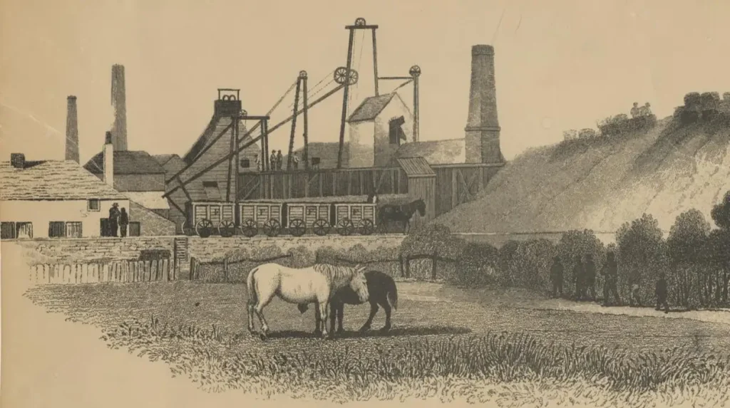
Coal mining influenced the Castle area by connecting rural communities to Newcastle’s wider industrial economy. Historical estates around Brunton and Fawdon contained coalmines, linking agricultural land, mineral extraction, employment and transport within the same Northumberland landscape.
Coal was central to Newcastle’s nineteenth-century economic development. The city’s industrial history included coal, shipbuilding, engineering, railways and associated manufacturing.
The northern settlements participated in this regional economy without becoming dense industrial districts themselves. Coal extraction formed one economic layer within a landscape that continued to contain farms and villages.
The 1848 description of the Brunton area specifically distinguishes the estate’s agricultural territory from its coalmines. That distinction shows how land could support different economic functions simultaneously.
Industrialisation also changed movement. Roads and later transport infrastructure connected rural settlements with Newcastle and surrounding industrial centres. Workers, agricultural producers and commercial traffic increasingly operated within a regional rather than purely local economy.
For modern families exploring Castle, this industrial background is significant because the area’s quiet residential character does not represent its entire economic history. Fields and suburban streets occupy land that previously supported agricultural production, estate management and mineral extraction.
What archaeological evidence survives in Castle Ward?
Castle Ward contains nationally protected archaeological remains, including prehistoric or Roman-period settlement evidence around Hazlerigg and a scheduled monument associated with Gardner’s Houses at Dinnington. These sites demonstrate that the northern Newcastle landscape has a settlement history extending far beyond modern suburbia.
Archaeological evidence provides a different historical perspective from surviving houses and roads. Buildings visible today represent only the latest layers of occupation.
Historic England lists two rectilinear enclosed settlements south of Castle Street at Hazlerigg as a Scheduled Monument. The site was first scheduled in 1970 and lies within the parish of Hazlerigg.
Scheduled Monument status identifies archaeological remains considered to be of national importance. The designation provides statutory protection under the Ancient Monuments and Archaeological Areas Act 1979.
Dinnington also contains the scheduled monument known as Gardner’s Houses settlement. Historic England identifies the site within Dinnington parish and records it as protected under the same archaeological legislation.
These archaeological sites are particularly important for historical interpretation because they demonstrate that settlement preceded the development of modern Newcastle.
The evidence also illustrates why apparently ordinary fields can have considerable heritage significance. Archaeological remains do not always survive as dramatic ruins. Enclosures, earthworks, buried structures and settlement traces can preserve information about land use and habitation.
Newcastle City Council identifies the Ancient Monuments and Archaeological Areas Act 1979 as the principal legislation governing archaeological monuments and uses criteria including period, rarity, documentation, group value, fragility and survival when considering national importance.
Which historic buildings reveal Castle Ward’s rural past?
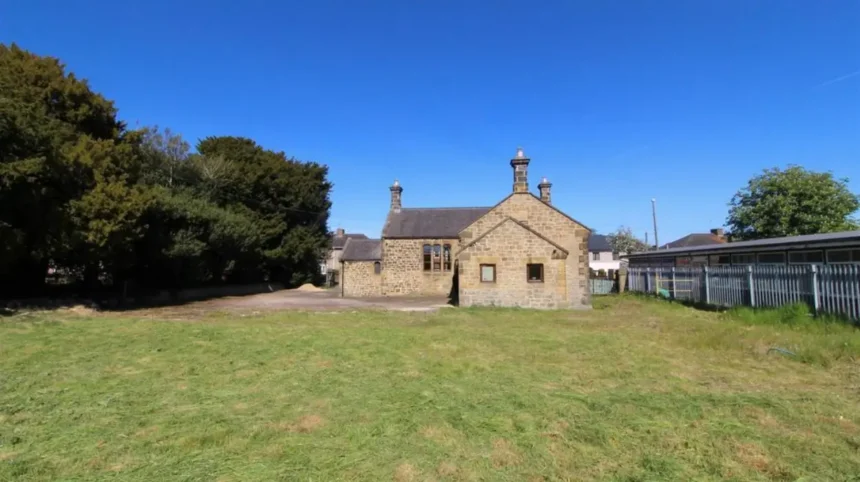
Historic buildings in the Castle area preserve evidence of agricultural settlement, nineteenth-century rural construction and former roadside activity. Listed farmhouses, cottages and agricultural buildings show how communities were organised before large-scale twentieth-century suburban development.
Historic England records several protected buildings around Dinnington and its surrounding countryside. These include South Shotton Edge House on the Old A1, an early nineteenth-century stone house associated with the former Red Lion Inn.
The building demonstrates the importance of historic roads to rural communities. It was formerly the Red Lion Inn and stood on the Great North Road, a major route through northern England.
South Shotton Edge Cottage and its associated outbuildings are also Grade II listed. Historic England identifies the structures as early nineteenth-century buildings and records that the outbuildings were originally constructed as stables and accommodation associated with the Red Lion Inn.
Another surviving feature is the early nineteenth-century gingang at Seven Mile Farm. Historic England records its stone construction, slate roof and distinctive internal roof structure, including evidence of a former drive-shaft opening in an adjacent barn wall.
These buildings are valuable because they reveal the practical organisation of rural life. Farms required barns, stables, storage buildings, accommodation and machinery spaces. Their architecture therefore provides evidence about agricultural processes as well as building techniques.
Such structures also help genealogical researchers. Property names, farms, inns and roads often provide geographical clues in historic documents when parish names changed or administrative boundaries were redrawn.
How did suburban development change Castle Ward during the twentieth century?
Twentieth-century suburban development transformed Castle from a predominantly rural landscape into a mixed environment containing established villages, residential estates, transport infrastructure, schools, community facilities and later large-scale housing development around Newcastle Great Park.
Newcastle’s urban expansion accelerated during the twentieth century as population growth, improved transport and housing demand pushed development beyond the historic city centre.
The northern edge presented a different development environment from densely built inner Newcastle. Large areas of open land allowed housing schemes to develop around existing villages and roads.
Kingston Park, Hazlerigg and surrounding communities became increasingly connected with the wider Newcastle urban area. The process did not replace every older settlement. Instead, new housing was layered around established communities.
The changing boundaries of Castle Ward also reflect this transformation. The Local Government Boundary Commission’s 2025 final recommendations considered community identity, electoral equality and existing connections when reorganising the northern wards. The recommendations created Kingston Park and Dinnington as a separate ward while retaining Castle as the name for the neighbouring ward.
The changes became effective for the local elections held on 7 May 2026. Newcastle City Council confirms that the election used new boundaries across 26 wards.
For historical research, the boundary changes provide a useful reminder that the same neighbourhood can appear under different administrative descriptions across census returns, electoral registers and planning documents.
What role does Newcastle Great Park play in the area’s modern history?
Newcastle Great Park represents the latest major phase of northern Newcastle’s suburban expansion. Its development illustrates how former open land became a planned residential environment while remaining connected to older villages, roads, parish boundaries and archaeological landscapes.
Newcastle Great Park developed as a major expansion area in the north-western part of the city. Its emergence changed the relationship between established settlements and newly constructed residential neighbourhoods.
The planning history is particularly important because large developments introduce new roads, homes, schools, public spaces and community infrastructure over land that previously had different uses.
The Local Government Boundary Commission’s review recorded competing considerations around the relationship between Newcastle Great Park, Brunswick, Hazlerigg and Dinnington. The final arrangement placed Dinnington in Kingston Park and Dinnington while retaining Castle for the neighbouring northern communities.
This provides a clear example of how contemporary communities influence administrative geography.
For families, the significance of Great Park extends beyond housing. Its development represents a new phase in Newcastle’s urban history, comparable in structural importance to earlier transitions from agricultural land to industrial and suburban uses.
The historical landscape therefore contains several chronological layers: rural estates, agricultural villages, industrial activity, twentieth-century suburbanisation and twenty-first-century planned development.
Why is Castle Ward relevant to families interested in local history?
Castle Ward provides families with a compact study area for understanding how Newcastle developed from rural Northumberland landscapes into a modern metropolitan city through archaeology, farming, industrialisation, suburban expansion, transport changes and successive local-government reforms.
Children studying local history can identify physical evidence rather than relying only on written accounts.
A historic farm building can introduce agricultural history. A scheduled archaeological site can introduce Roman or earlier settlement. An old road can demonstrate transport history. A parish boundary can explain local government. A modern housing development can demonstrate urban expansion.
The area is therefore suitable for chronological comparison.
One useful approach is to examine how land use changed rather than treating history as a sequence of isolated dates. A field associated with farming can later become part of a housing development. A rural road can become a suburban transport route. A former estate can leave its name on modern streets or local institutions.
The archaeological record strengthens this educational value. Historic England’s protected sites at Hazlerigg and Dinnington demonstrate that the area’s human history extends beyond the surviving nineteenth- and twentieth-century buildings.
Families should distinguish between publicly accessible places and protected archaeological remains. Scheduled Monument status does not automatically mean that a site operates as a visitor attraction. Some heritage assets require protection precisely because their archaeological value depends on preserving remains in place.
To experience this historic landscape in person today, consult our comprehensive for itineraries and visiting parameters.
How can genealogists use Castle Ward’s historical records?
Genealogical research in Castle Ward requires attention to changing parishes, registration districts, rural districts and electoral boundaries. Researchers should identify the exact historical date before interpreting a place name because modern ward boundaries do not match older administrative geography.
Castle’s administrative history is particularly important for family historians.
The former Castle Ward Rural District existed from 1894 until 1974. Earlier records used different structures, including parishes, townships and registration districts.
The Newcastle upon Tyne registration district changed substantially during the twentieth century. Records show transfers involving areas connected with Castle Ward, including Dinnington, Hazlerigg, Woolsington and other northern settlements.
A birth, marriage or death record therefore needs to be interpreted according to the administrative system operating when the event occurred.
The same principle applies to census research. A person living in a village could appear under a parish, township, registration district, rural district or county designation that differs from the modern Newcastle address.
Property records also provide useful evidence. Farm names and historic buildings can help establish continuity when street names change.
For genealogists tracing families with Newcastle or Northumberland connections, comparing parish registers with census returns, civil registration indexes, electoral registers and historic maps provides a more reliable geographical framework.
The historical connection with landed estates can also help explain repeated family names associated with farms, villages and occupations.
How should Castle Ward’s heritage be preserved?
Castle Ward’s heritage depends on protecting archaeological remains, listed buildings, historic landscapes and surviving village character while managing new development. Preservation requires accurate records, appropriate planning controls and recognition of heritage assets outside traditional landmark buildings.
Newcastle City Council operates a Historic Environment framework covering conservation areas, listed buildings and scheduled monuments. The council states that conservation areas are places of special architectural or historic interest requiring careful management.
Castle is not itself a single conservation area. That distinction matters because heritage protection operates through different legal and planning mechanisms.
Scheduled Monuments receive statutory archaeological protection. Listed buildings receive protection for their special architectural or historic interest. Conservation areas protect the character of designated areas rather than individual buildings alone.
Historic England’s National Heritage List records the individual designations.
The protected archaeological settlements at Hazlerigg and Dinnington demonstrate the importance of buried or earthwork heritage. Historic farm structures demonstrate another form of heritage, where surviving buildings preserve evidence about construction and land use.
Modern planning creates another layer of responsibility. New roads and buildings can alter historic landscapes even when construction does not directly affect a listed structure.
Effective preservation therefore requires attention to setting as well as individual assets.
For local historians, photographs, oral histories, maps and building surveys provide additional evidence. These records help document change before future development alters the physical appearance of the area.
What does Castle Ward reveal about Newcastle’s long-term development?
Castle Ward shows that Newcastle’s growth occurred through successive layers rather than one continuous process. Rural settlement, estate management, coal extraction, metropolitan government, twentieth-century housing and twenty-first-century expansion each reshaped the northern landscape.
The area’s historical importance lies in this sequence of transformation.
Its rural origins remain visible through farms, historic roads, village names and protected buildings. Industrial history appears through evidence of coal extraction and connections with Newcastle’s wider economy. Administrative history survives in the changing boundaries of Castle Ward and its predecessor authorities.
The 1974 metropolitan reorganisation created a major institutional framework for the modern city. More recently, the 2026 electoral changes reorganised northern Newcastle again, placing Dinnington with Kingston Park while retaining Castle as an electoral ward name.
These changes do not erase older identities. They demonstrate how local geography operates at different levels.
For families, Castle Ward offers an accessible way to examine this relationship between history and the present. Quiet residential streets sit alongside archaeological remains, historic farms, village landscapes and modern development.
For educators, the area provides evidence for lessons about local government, industrialisation, archaeology, architecture and urban growth.
For genealogists, changing administrative boundaries explain why historical records can appear inconsistent.
For heritage researchers, the area demonstrates the need to protect both visible buildings and less obvious archaeological landscapes.
Castle Ward is therefore best understood as a layered northern landscape within Newcastle upon Tyne. Its quiet suburban character is a modern result of a much longer history, beginning with rural settlement and continuing through industrial change, metropolitan incorporation and planned urban expansion.