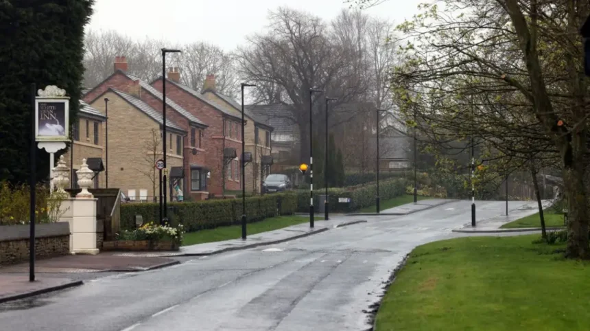
Castle Ward is a northern Newcastle upon Tyne ward shaped by village settlements, post-war expansion, transport corridors, open land and newer development. Its history is closely connected to the former Castle Ward Rural District, created within Northumberland’s local-government system before the 1974 reorganisation.
- What is Castle Ward in Newcastle upon Tyne?
- How did Castle Ward develop historically?
- How does Castle Ward connect to Newcastle’s wider history?
- What are the typical commute times from Castle Ward to Newcastle city centre?
- Which Metro stations serve Castle Ward and nearby areas?
- How does Metro travel connect with Newcastle city centre?
- Is the Metro equally accessible throughout the ward?
- Which schools are associated with Castle Ward and its surrounding communities?
- How have schools and transport influenced northern Newcastle’s development?
- What historical evidence can researchers find in Castle Ward?
- How is Castle Ward’s heritage protected today?
- What does Castle Ward reveal about Newcastle’s long-term urban history?
- Why does Castle Ward matter for future historical research?
For modern readers, the most important point is that Castle Ward is not the same place as Newcastle’s medieval Castle Garth. The medieval castle occupies the historic centre beside the River Tyne, while the modern Castle ward is a northern administrative area. The distinction matters when researching transport, schools, housing, local history and genealogy.
Newcastle’s wider northern development also reflects the city’s long movement beyond its medieval core. Newcastle City Council records the city’s origins in the Roman settlement of Pons Aelius and the Norman castle founded in 1080 by Robert Curthose, son of William the Conqueror.
The present Castle ward provides a useful case study in how rural parishes, industrial-era infrastructure, suburban growth and modern planned development became part of the Newcastle urban system.
What is Castle Ward in Newcastle upon Tyne?
Castle Ward is a modern Newcastle City Council electoral ward in the northern part of Newcastle upon Tyne, with its present boundaries introduced for the 2026 elections and neighbouring areas including Great Park, Brunswick and Hazlerigg.
The name has deeper administrative roots. The Local Government Act 1972 incorporated the former Castle Ward Rural District into the new metropolitan district of Newcastle upon Tyne. The legislation specifically identified the parishes of Brunswick, Dinnington, Hazlerigg, North Gosforth and Woolsington within the former Castle Ward Rural District.
This administrative history explains why the name “Castle” appears in records that are geographically distant from Newcastle Castle itself. Researchers examining census records, electoral registers, parish documents and land records need to distinguish the modern electoral ward from the medieval Castle Garth.
The 2026 electoral reorganisation changed the pattern again. Newcastle City Council’s election documentation lists Castle and Kingston Park and Dinnington as separate wards from the May 2026 elections.
This distinction is especially important for historical comparison. Older sources can describe Dinnington or Kingston Park as part of Castle ward, while newer records can place them within different electoral boundaries.
The boundary system therefore reflects administrative change rather than the creation or disappearance of a physical community.
Why does the name Castle appear in northern Newcastle?
The name derives from the former Castle Ward Rural District rather than from Newcastle’s medieval castle alone. The rural district was part of Northumberland before local-government reorganisation transferred its constituent parishes into Newcastle’s metropolitan district in 1974.
This is a useful example of how British administrative geography preserves older territorial names. A ward name can survive after the original administrative structure has changed.
The modern ward should therefore be understood as part of Newcastle’s northern administrative history, not as an extension of the Castle Garth historic monument.
How did Castle Ward develop historically?
Castle Ward developed from rural parishes and village settlements into a modern northern Newcastle area through local-government reorganisation, improved roads, suburban expansion, new housing and planned growth around communities such as Hazlerigg and Brunswick.
Before metropolitan reorganisation, this northern territory formed part of Northumberland’s administrative structure. The Local Government Act 1972 transferred the Castle Ward Rural District parishes of Brunswick, Dinnington, Hazlerigg, North Gosforth and Woolsington into the Newcastle metropolitan district.
The change took effect on 1 April 1974. Newcastle therefore expanded beyond its historic county-borough boundaries and absorbed surrounding districts and parishes into a metropolitan local-government framework.
This process followed a wider pattern across England. Large urban authorities incorporated surrounding settlements as population growth and commuting patterns increasingly connected villages with established cities.
What changed after 1974?
The 1974 reorganisation gave Newcastle responsibility for a much larger geographical area. Formerly rural settlements became part of the metropolitan city while retaining individual parish identities and distinctive built environments.
Dinnington continued to function as a village community. Hazlerigg developed with stronger suburban characteristics. Brunswick also retained a village identity while becoming increasingly connected to Newcastle’s employment and transport systems.
The growth of Newcastle Great Park added another major phase. Planned development introduced substantial new housing and supporting infrastructure to the northern edge of the city.
The result is a layered landscape. Historic village streets coexist with twentieth-century housing and twenty-first-century development.
How important is local parish history?
Parish history remains important because civil parishes provide a framework for understanding local land ownership, community institutions, churches, schools and historic settlement patterns.
Dinnington is particularly relevant for researchers because it has an established neighbourhood planning framework. Newcastle City Council records that the Dinnington Neighbourhood Plan covering 2021–2036 was formally made on 2 June 2025 after a successful referendum.
Neighbourhood planning provides modern evidence of how a historic settlement manages growth while maintaining local identity.
How does Castle Ward connect to Newcastle’s wider history?
Castle Ward connects Newcastle’s rural northern edge with the city’s wider history of Roman settlement, Norman foundation, industrial expansion, railway development and twentieth-century metropolitan growth, showing how Newcastle expanded from a compact riverside settlement into a large modern urban authority.
Newcastle’s origins extend to the Roman period. Newcastle City Council identifies Pons Aelius as the Roman fort established on the high ground above the River Tyne and links this site to the earliest known river crossing in the modern city.
The Norman period produced another major transformation. Robert Curthose founded the first castle at Newcastle in 1080. The settlement subsequently developed around this strategic location.
The medieval Castle Garth therefore represents a very different historical layer from modern Castle Ward.
What is the relationship between Castle Ward and Newcastle Castle?
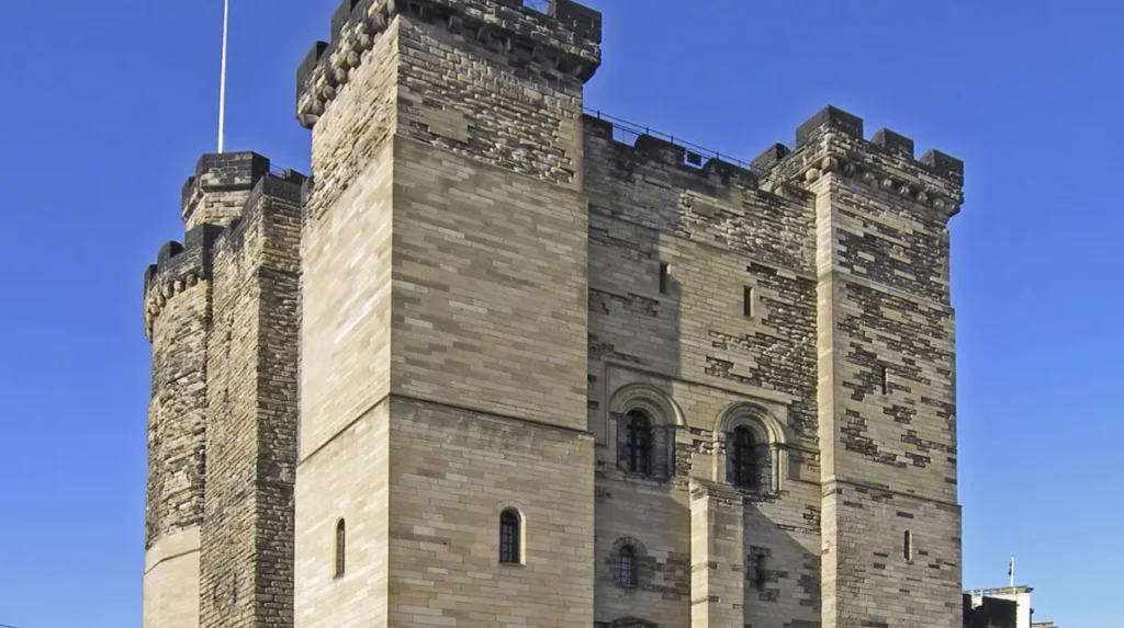
Newcastle Castle is in the historic city centre, while Castle Ward is a northern electoral district. The two share a name but represent different geographical and administrative entities.
Historic Newcastle Castle was refortified in stone under Henry II between 1168 and 1178. Historic England records the keep’s construction date as 1168–78 and identifies later additions including the North Gate, curtain walls and Black Gate.
The medieval fortress subsequently became less strategically important after Newcastle’s town walls were constructed in the later thirteenth century. The keep later underwent restoration, including work by Newcastle Corporation in the nineteenth century.
Newcastle City Council now identifies Castle Keep as one of the city’s Scheduled Monuments.
For historical research, the distinction prevents an important geographical error: Castle Ward is a northern administrative area, whereas Castle Garth is a medieval archaeological and architectural complex in central Newcastle.
What are the typical commute times from Castle Ward to Newcastle city centre?
Commute times from Castle Ward depend on the village and transport mode, but Dinnington bus services provide direct connections to central Newcastle, while areas nearer Kingston Park can combine local buses with Metro services for city-centre journeys.
Current bus timetables demonstrate the connection clearly. Arriva’s Service 44 runs between Dinnington and Newcastle via Gosforth. Timed stops show journeys from Dinnington through Hazlerigg and Regent Centre to Haymarket.
The published timetable gives a useful illustration of scheduled journey length. A morning Service 44 leaves Dinnington at 08:05 and reaches Haymarket at 08:45, producing a scheduled 40-minute journey between those timing points. Other departures have different timings.
Service 45 provides another direct Dinnington-to-Newcastle route. Its timetable shows Dinnington, Brunswick Village, Wideopen, Regent Centre and Haymarket as major points. One scheduled journey runs from 09:26 at Dinnington to 09:55 at Haymarket, a 29-minute timing-point journey.
These figures are more useful than a single advertised “commute time” because Castle Ward covers different settlements.
Which areas have the shortest public-transport journeys?
Locations closer to Kingston Park and the Metro corridor have access to rapid transit connections that northern village residents can reach by bus, car, bicycle or walking routes depending on their starting point.
Kingston Park Metro station connects with the wider Tyne and Wear Metro network. The service pattern also links Kingston Park with Newcastle Airport and the city-centre network.
For comparison, Kingston Park Stadium’s published travel information identifies Kingston Park and Bank Foot as the closest Metro stations to the stadium and describes the Metro as a direct option from Newcastle Central Station.
This creates two distinct transport patterns: direct bus travel from village communities such as Dinnington, and bus-to-Metro or local access to Metro stations around Kingston Park.
Why do commute times vary?
Commute times vary because Castle Ward contains settlements with different distances from the A1, A1056, Gosforth, Regent Centre and Metro stations.
Peak-period traffic also affects road journeys. Public transport timetables provide scheduled timings rather than guaranteed door-to-door journey durations. Waiting, walking and interchange time must therefore be added when calculating a complete commute.
For property research, the most accurate method is to assess a specific postcode rather than applying one journey time to the entire ward.
Which Metro stations serve Castle Ward and nearby areas?
Castle Ward does not function as a single Metro station area; residents in its northern communities use nearby stations such as Kingston Park and Bank Foot, while bus services connect villages including Dinnington and Brunswick with Newcastle’s wider transport network.
The Metro line is particularly important because the northern part of Newcastle has developed around transport corridors rather than a single central railway station.
Kingston Park is a significant access point. Current timetable information shows frequent Metro services through Kingston Park on the Airport–South Hylton route.
Bank Foot is another nearby station serving the western side of the northern suburban area. The two stations are particularly relevant to residents living close to Kingston Park and Newcastle Great Park.
How does Metro travel connect with Newcastle city centre?
Metro services provide a rail-based alternative to road travel into central Newcastle. Passengers can travel towards central stations and interchange with other Metro routes or local services.
Newcastle Central Station is also an important interchange because it combines Metro services with national rail connections. This gives northern Newcastle residents access to regional destinations beyond the city.
The practical advantage of Metro travel is therefore network connectivity rather than simply distance.
Is the Metro equally accessible throughout the ward?
No. The geography of the ward makes access uneven.
Dinnington, for example, is connected directly to Newcastle by bus services rather than possessing a Metro station within the village. Arriva’s current Service 44 and Service 45 timetables demonstrate this bus-based connection.
Residents nearer Kingston Park have more direct access to Metro stations.
This difference matters when comparing homes within the wider Castle area. Two properties carrying the same ward designation can have substantially different walking distances to public transport.
Which schools are associated with Castle Ward and its surrounding communities?
Education provision around Castle Ward includes established primary schools such as Dinnington First School and Kingston Park Primary School, while newer northern developments connect families with schools across Great Park, Gosforth and surrounding Newcastle neighbourhoods.
Newcastle City Council’s school directory provides the current official register of schools and distinguishes first schools, primary schools, middle schools, secondary schools and other education types.
Dinnington First School is particularly significant for the historical settlement because it serves a community that predates modern metropolitan Newcastle.
Kingston Park Primary School serves the Kingston Park area and forms part of the broader educational network used by families living across northern Newcastle.

What does current admissions data show?
Newcastle’s 2026 Reception allocation data provides a useful illustration of demand. Dinnington First School had a published admission number of 60 and received 153 applications for the 2026 intake. Sixty places were allocated on national offer day, with 21 allocated under the sibling criterion and 39 under distance.
Kingston Park Primary School had a published admission number of 90 in the same 2026 allocation data. It received 123 applications and allocated 82 places on national offer day. Fifty allocations were made under the distance criterion and 28 under the sibling criterion.
These figures demonstrate why school availability should be checked for the exact academic year rather than inferred from historical reputation or proximity.
Does a nearby school guarantee a place?
No. Newcastle City Council explicitly states that school vacancy information is guidance and does not guarantee a place. Applications are ranked using each school’s published oversubscription criteria when demand exceeds available places.
Distance can form part of the allocation process, but sibling priority, statutory requirements and each school’s admissions rules also affect outcomes.
Families researching property should therefore check the current admissions policy and catchment arrangements before making decisions.
How have schools and transport influenced northern Newcastle’s development?
Schools and transport have supported the transformation of northern Newcastle from dispersed villages into connected suburban communities, with roads, bus routes, Metro infrastructure, primary schools and planned housing creating stronger links between local settlements and the city.
Transport infrastructure has always influenced settlement growth. Roads connecting Newcastle with Northumberland provided movement for workers, goods and services before modern suburban development.
The twentieth century intensified this relationship. Improved road infrastructure made it easier for residents to live farther from the city centre while commuting to employment elsewhere.
The later development of Metro infrastructure added a rapid-transit layer to this northern geography.
What role does Newcastle Great Park play?
Newcastle Great Park represents one of the most substantial modern development phases on the city’s northern edge. It introduced large-scale housing and supporting infrastructure into an area previously characterised by agricultural land and established villages.
The development changed the relationship between older settlements and newer residential districts.
Its growth also increased demand for schools, transport, public services, open space and community facilities.
This pattern illustrates a recurring feature of Newcastle’s urban history: the city expands by integrating existing landscapes rather than replacing all earlier settlement structures.
How does the historical landscape survive?
Older village centres remain important evidence of earlier settlement. Street layouts, churches, community buildings, older houses, field boundaries and parish institutions preserve traces of pre-metropolitan Newcastle.
The survival of these features gives researchers physical evidence alongside documentary records.
The result is a layered landscape rather than a uniform suburb.
What historical evidence can researchers find in Castle Ward?
Historical research in Castle Ward draws on parish records, electoral boundaries, neighbourhood plans, maps, school records, census material, architectural evidence and local-government documents, allowing researchers to trace settlement, family, land-use and administrative changes across generations.
Genealogical researchers should begin with parish and civil registration records before comparing them with census returns and electoral documentation.
Administrative terminology requires particular care. A family recorded within Castle Ward in an older document does not automatically correspond to the same modern electoral boundary.
The Local Government Act 1972 provides a crucial historical reference because it identifies the parishes incorporated into Newcastle’s metropolitan district.
Why are ward boundaries important for genealogy?
Ward boundaries affect how addresses appear in electoral registers, local authority documents and administrative datasets.
The 2026 Newcastle electoral changes demonstrate how quickly these boundaries can alter. Newcastle City Council states that the May 2026 election used new boundaries across the city’s 26 wards.
A genealogist therefore needs to identify the date of a document before assigning a historical address to a modern ward.
Parish boundaries can sometimes provide a more stable historical reference than electoral wards.
What sources help reconstruct local history?
Useful sources include Newcastle City Council’s historic environment records, planning documents, neighbourhood plans, school records, electoral information and national legislation.
Newcastle’s Historic Environment Record identifies Castle Garth as a medieval defence site and records archaeological information about the historic castle complex.
Dinnington’s Neighbourhood Plan provides another modern documentary layer. The plan covers 2021–2036 and forms part of Newcastle’s statutory development framework following its formal adoption in June 2025.
Together, such sources allow researchers to connect buildings and landscapes with administrative history.
How is Castle Ward’s heritage protected today?
Heritage protection in Newcastle operates through listed-building controls, conservation areas, Scheduled Monument protection, local heritage policies and archaeological records, although Castle Ward’s heritage is distributed across villages, landscapes and historic structures rather than concentrated in one monument.
Newcastle City Council identifies 12 conservation areas across the city and explains that conservation areas protect places with special architectural or historic interest.
Scheduled Monument protection provides a separate legal mechanism for nationally important archaeological sites. Newcastle lists Castle Keep, the Town Wall and Hadrian’s Wall among its Scheduled Monuments.
The distinction matters because not every historic building or landscape receives the same type of protection.
How does preservation affect modern development?
Modern planning must balance new housing, transport infrastructure and community facilities with the preservation of significant historic character.
This issue is especially relevant to northern Newcastle because new development sits beside older villages and agricultural landscapes.
The Dinnington Neighbourhood Plan provides a local example of planning at community level. Its policies form part of the statutory development plan and therefore influence planning decisions within the parish.
This creates a documentary record of how residents, planners and authorities approach future development around an established settlement.
What does Castle Ward reveal about Newcastle’s long-term urban history?
Castle Ward demonstrates how Newcastle’s modern geography developed through administrative reform, village preservation, suburban expansion, transport investment and planned housing, creating a northern landscape where medieval city history, rural heritage and contemporary development remain connected.
The historical importance of Castle Ward lies in its combination of continuity and change.
The area was once administered through Northumberland’s rural local-government structure. The Local Government Act 1972 transferred its constituent parishes into Newcastle’s metropolitan district.
Later housing development changed the physical landscape. Transport improvements reduced the functional distance between northern villages and Newcastle’s employment and cultural centre.
The 2026 boundary changes demonstrate that administrative geography continues to evolve. Newcastle now lists Castle and Kingston Park and Dinnington as separate wards.
This changing geography has direct relevance for historians and genealogists because administrative labels often provide the first clue to locating an old address.
What remains historically significant?
The strongest surviving historical evidence is distributed rather than concentrated. Examples include village layouts, parish institutions, historic roads, older buildings, archaeological records and documentary boundaries.
Newcastle’s broader heritage record confirms that the city contains evidence extending from Roman Pons Aelius through the Norman foundation and medieval castle to modern urban expansion.
Castle Ward forms part of the later northern phase of that expansion.
Its history therefore belongs to the story of metropolitan Newcastle rather than to the medieval castle alone.
For visitors wanting to connect the city’s historic development with places they can explore today, consult our comprehensive for itineraries and visiting parameters.
Why does Castle Ward matter for future historical research?
Castle Ward will remain important to historical research because its changing boundaries, village communities, planned development and transport infrastructure create a detailed record of how Newcastle absorbed rural territory while retaining evidence of earlier settlement patterns and local identities.
Future researchers will have access to an expanding documentary record.
Planning applications will document new housing and infrastructure. School records will show demographic changes. Electoral boundaries will record administrative restructuring. Neighbourhood plans will preserve evidence of local planning priorities.
Digital mapping will also make comparison between historical and modern landscapes easier.
For genealogists, this combination is valuable because a single address can be examined through multiple periods.
A house can be located on historic maps, connected with a parish, identified in census material and then compared with later electoral boundaries.
For educators, Castle Ward provides a practical example of how geography and history interact.
Students can examine the effects of the 1974 metropolitan reorganisation, compare village and suburban settlement patterns, investigate transport-led growth and analyse how planning documents shape the modern landscape.
For heritage researchers, the area demonstrates why preservation is not limited to major monuments.
Historic character can survive through street layouts, parish structures, community buildings, archaeological deposits and documentary records.
Castle Ward therefore belongs within the wider historical study of Newcastle upon Tyne. Its story begins with rural Northumberland administration, continues through the 1974 metropolitan transformation and extends into the twenty-first-century expansion of northern Newcastle. Its transport links, schools and new development are modern expressions of a much longer process of geographical change.