

Hadrian’s Wall Country offers a direct connection to Roman Britain through frontier forts, military roads, archaeological remains and landscapes shaped by nearly 2,000 years of history. For residents and visitors staying in Chapel Park, Newcastle upon Tyne, the region provides accessible day trips combining ancient heritage, local communities and outdoor exploration.
- What is Hadrian’s Wall, and why was it built?
- How did Hadrian’s Wall develop through Roman history?
- AD 43: Roman conquest of Britain
- Around AD 100: The Stanegate frontier
- AD 122 onwards: Construction of Hadrian’s Wall
- Second and third centuries: Military and civilian communities
- Fourth and early fifth centuries: Changing imperial authority
- Medieval period to modern preservation
- Which Hadrian’s Wall sites are easiest to visit from Chapel Park?
- Heddon-on-the-Wall: A short introduction to the frontier
- Corbridge Roman Town: Administration and commerce
- Chesters Roman Fort: Engineering and military organisation
- Housesteads Roman Fort: Life on the frontier
- What makes the central section of Hadrian’s Wall historically important?
- How did Roman soldiers live and work along Hadrian’s Wall?
- What were milecastles and turrets?
- How did forts support military operations?
- Who lived along the frontier?
- What can visitors learn about Roman engineering from Hadrian’s Wall?
- How should visitors plan an easy day trip from Chapel Park?
- Option one: A shorter eastern heritage trip
- Option two: A military history day
- Option three: A landscape-focused excursion
- What should visitors bring?
- How is Hadrian’s Wall preserved as a UNESCO World Heritage Site?
- Why is Hadrian’s Wall important for education and historical research?
- What should visitors remember when exploring Hadrian’s Wall Country?
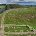
Hadrian’s Wall stretches across northern England from Wallsend, near Newcastle, to Bowness-on-Solway in Cumbria. The Roman emperor Hadrian ordered its construction in AD 122 to establish a controlled frontier across the northern province of Britannia. Today, the surviving wall, forts, museums and archaeological sites form part of the UNESCO World Heritage property known as the Frontiers of the Roman Empire.
Chapel Park provides a useful starting point for exploring the eastern and central sections of the frontier. Visitors can plan journeys to Heddon-on-the-Wall, Corbridge Roman Town, Chesters Roman Fort, Housesteads Roman Fort and the central wall landscape around Once Brewed. Each destination reveals a different aspect of Roman military organisation, engineering, trade and everyday life.
This guide explains the historical background, principal landmarks, travel considerations and preservation work that make Hadrian’s Wall Country a valuable destination for history enthusiasts, cultural tourists, educators and heritage researchers.
What is Hadrian’s Wall, and why was it built?
Hadrian’s Wall is a 73-mile Roman frontier built across northern England from AD 122. It controlled movement, supported military surveillance, and marked the north-western boundary of Roman Britannia. Its forts, milecastles, turrets and roads formed an integrated military system.
Emperor Hadrian ruled the Roman Empire from AD 117 to AD 138. His government prioritised the consolidation of imperial territories rather than unlimited expansion. His visit to Britain in AD 122 coincided with the development of a new frontier across the narrowest practical land corridor between the River Tyne and Solway Firth.
The Roman army constructed the barrier over approximately six years, although building work and modifications continued as military requirements changed. The completed frontier measured approximately 73 modern miles, equivalent to 80 Roman miles. It extended from Wallsend in the east to Bowness-on-Solway in the west.
The frontier was more than a wall. Its defensive system included forts, guarded gateways, observation towers, a northern ditch, the southern earthwork known as the Vallum, and roads connecting military installations. Soldiers monitored movement, communicated information and maintained the authority of Rome across northern Britain.
For visitors travelling from Chapel Park, this wider understanding is essential. The surviving masonry represents only one element of a complex archaeological landscape. Forts such as Housesteads and Chesters reveal military organisation, while Corbridge illustrates the commercial and administrative activity that supported the frontier.
How did Hadrian’s Wall develop through Roman history?
Hadrian’s Wall developed through several phases of Roman military occupation, beginning in AD 122 and continuing beyond Hadrian’s reign. Its original design changed during construction, and later emperors modified the frontier as military priorities, political circumstances and settlement patterns evolved.
The history of Hadrian’s Wall connects directly with the wider Roman occupation of Britain. The following chronology identifies the principal milestones relevant to a visit.
AD 43: Roman conquest of Britain
Roman forces invaded Britain under Emperor Claudius in AD 43. Roman control expanded across much of southern Britain and advanced into Wales and northern England. Military campaigns and frontier installations gradually established the conditions for a permanent northern boundary.
Around AD 100: The Stanegate frontier
Before Hadrian’s Wall, Roman military installations occupied the corridor between Corbridge and Carlisle. The Stanegate was a major military road connecting this region. It provided a logistical foundation for the later frontier.
AD 122 onwards: Construction of Hadrian’s Wall
Hadrian ordered the construction of the wall after his visit to Britain. The original design incorporated a wall, milecastles, turrets and a defensive ditch. Forts were subsequently added along the frontier, and the southern Vallum earthwork strengthened the wider military landscape.
Second and third centuries: Military and civilian communities
The frontier supported soldiers, merchants, craftspeople, veterans and families. Military settlements developed around forts, creating communities linked to trade, transport, administration and religious practice. Inscriptions and excavated objects demonstrate connections between Britain and other regions of the Roman Empire.
Fourth and early fifth centuries: Changing imperial authority
Roman military control weakened as political and economic pressures affected the western empire. Troops and administrative structures gradually withdrew or changed. The end of Roman rule in Britain did not immediately erase the frontier’s settlements, roads or influence on the landscape.
Medieval period to modern preservation
Local communities reused stones from abandoned Roman structures in buildings, churches and agricultural boundaries. Later antiquarians, archaeologists and conservation organisations documented surviving remains. The wall received UNESCO World Heritage recognition in 1987, placing it within an internationally significant programme of heritage protection.
This timeline explains why the landscape contains different forms of evidence. A surviving wall section, an excavated fort and a buried civilian settlement represent different stages and aspects of the frontier’s history.
Which Hadrian’s Wall sites are easiest to visit from Chapel Park?
The most practical day trips from Chapel Park combine accessible eastern sites with the more dramatic central frontier. Heddon-on-the-Wall suits a shorter visit, Corbridge offers extensive archaeological remains, and Chesters and Housesteads provide detailed evidence of Roman military life.
Chapel Park lies in Newcastle upon Tyne, making the eastern end of Hadrian’s Wall a logical starting point. Travel times depend on the exact departure point, traffic, roadworks and parking arrangements. Check a current route planner before setting off, particularly when visiting several sites in one day.
Heddon-on-the-Wall: A short introduction to the frontier
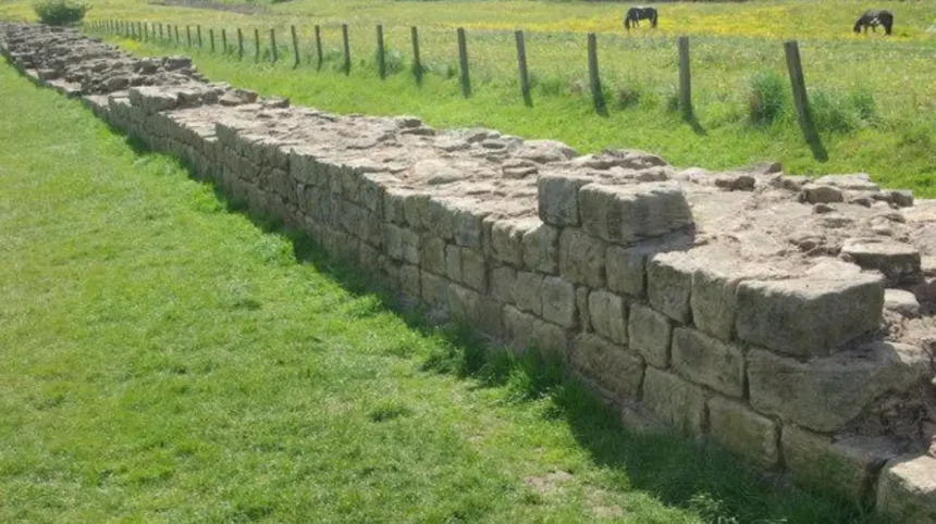
Heddon-on-the-Wall contains a notable surviving section of the Roman wall west of Newcastle. The exposed masonry demonstrates the construction methods used along the eastern part of the frontier. It also helps visitors understand how the ancient boundary passes through a modern rural settlement.
This destination works well for a shorter heritage outing. Visitors can examine the visible masonry and compare the surviving structure with historical plans of the frontier. The surrounding landscape illustrates how Roman engineering responded to terrain and transport routes.
The visible wall is not a complete reconstruction. It represents surviving archaeological fabric, and its condition reflects centuries of weathering, stone removal and conservation.
Corbridge Roman Town: Administration and commerce
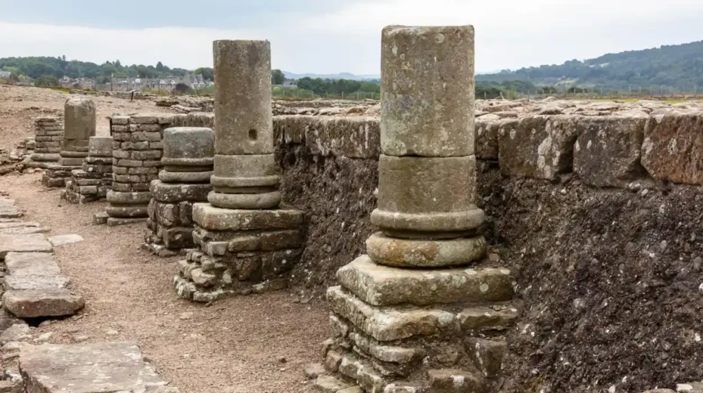
Corbridge Roman Town stands south of the main wall line and offers a different perspective on frontier life. The settlement developed near an important road junction and played a role in military supply, administration and commerce.
Excavated remains reveal buildings, streets and infrastructure associated with Roman occupation. Archaeological finds help researchers investigate the relationship between military forces and civilian communities.
Corbridge is especially valuable for visitors interested in economic history. Military installations required food, equipment, transport animals, building materials and specialist services. Settlements such as Corbridge connected these needs with regional production and long-distance trade.
Chesters Roman Fort: Engineering and military organisation
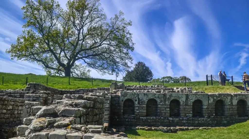
Chesters Roman Fort, also known as Cilurnum, preserves evidence of a military installation beside the River North Tyne. Its archaeological remains include fort buildings and a bathhouse associated with the Roman garrison.
The bathhouse demonstrates that Roman military life involved sanitation, recreation and organised daily routines alongside defence and patrol duties. Water supply, heating systems and building layouts reveal the technical knowledge required to sustain a permanent garrison.
Chesters also provides evidence of transport infrastructure. The remains of a Roman bridge near the site demonstrate how the military road network crossed the river.
Housesteads Roman Fort: Life on the frontier
Housesteads Roman Fort occupies an elevated position along the central frontier. Its surviving remains include the outlines of barracks, granaries, a headquarters building and communal latrines.
The site demonstrates how Roman military planners organised accommodation, food storage, administration and sanitation within a fortified enclosure. Its position also provides a clear understanding of the relationship between the wall, surrounding terrain and observation points.
Housesteads is particularly useful for educational visits because its visible building foundations help explain the layout of a Roman fort. The surrounding countryside also reveals why the central wall follows elevated ground and prominent rocky formations.
What makes the central section of Hadrian’s Wall historically important?
The central section of Hadrian’s Wall preserves some of its most recognisable landscapes, including exposed stonework, rocky escarpments, milecastles and fort remains. Its topography reveals how Roman engineers integrated natural obstacles with constructed defences and military observation points.
The central frontier around Once Brewed, Cawfields and Walltown offers a different experience from the eastern settlements. Here, the wall follows ridges and rocky outcrops, producing a landscape in which archaeology and natural geography remain closely connected.
Once Brewed and the wider frontier landscape
Once Brewed is a useful base for exploring the central section of Hadrian’s Wall. Nearby attractions include sections of the wall, countryside walking routes and archaeological sites. The surrounding area helps visitors understand how Roman engineers used changes in elevation to improve visibility and strengthen the frontier.
The nearby Steel Rigg area provides access to well-known stretches of the wall along prominent ridges. Walkers encounter exposed stonework and views across the Northumberland landscape. Routes vary in length and difficulty, so visitors should select a walk that matches their fitness, footwear and available daylight.
Cawfields and Walltown Crags
Cawfields and Walltown Crags contain important surviving sections of wall and associated archaeological features. Their rugged terrain demonstrates the strategic relationship between the defensive barrier and the natural landscape.
At these locations, visitors can observe how the wall approaches steep ground and rocky outcrops. Natural barriers reduced the need for continuous masonry in some places, while constructed sections maintained the frontier’s overall alignment.
English Heritage identifies several surviving stretches of wall in this region, including sections at Walltown Crags, Cawfields and nearby locations. These remains form part of a wider archaeological landscape rather than isolated monuments.
The central region also illustrates the importance of conservation. Walking paths, visitor facilities and designated routes help people experience the landscape while limiting damage to fragile archaeological remains.
How did Roman soldiers live and work along Hadrian’s Wall?
Roman soldiers stationed along Hadrian’s Wall performed duties beyond guarding the frontier. They maintained buildings, patrolled routes, managed supplies and supported communications. Their forts also accommodated administrative work, storage, training and facilities required for everyday military life.
The Roman army organised the frontier through a combination of large forts, smaller guarded gateways and observation towers. Each installation served a specific function within the wider defensive system.
What were milecastles and turrets?
A milecastle was a small fortified gateway positioned at approximately one-Roman-mile intervals along the wall. These installations controlled access through the barrier and provided space for a small military detachment.
Turrets were observation towers positioned between milecastles. The original layout provided two turrets between each pair of milecastles, creating observation points at intervals of roughly one-third of a Roman mile. Soldiers used these positions to monitor the surrounding countryside and communicate with nearby installations.
The system demonstrates the importance of surveillance and controlled movement. Hadrian’s Wall did not depend solely on its height or thickness. Its effectiveness relied on the coordination of people, roads, gateways and observation points.
How did forts support military operations?
Larger forts housed auxiliary regiments, which consisted of soldiers recruited from communities across the Roman Empire. Auxiliary units included infantry, cavalry and mixed formations.
Fort layouts commonly incorporated barracks, headquarters buildings, granaries, workshops and sanitary facilities. Granaries stored food supplies, while headquarters buildings supported administration and military command. Barracks provided accommodation for soldiers.
Housesteads illustrates this organisation through its surviving foundations. Chesters adds evidence of bathing facilities and transport infrastructure. Corbridge complements both sites by demonstrating how military installations connected with nearby civilian activity.
Who lived along the frontier?
The frontier was home to more than Roman soldiers. Archaeological evidence indicates the presence of merchants, craftspeople, veterans and soldiers’ families in settlements associated with the forts.
The garrison was culturally diverse. Soldiers came from different provinces of the Roman Empire, bringing languages, customs and religious traditions. Inscriptions and religious objects provide evidence of this cultural exchange.
The frontier therefore served as both a military boundary and a place of interaction. Its history reflects the movement of people, goods and ideas across the Roman world.
What can visitors learn about Roman engineering from Hadrian’s Wall?
Hadrian’s Wall demonstrates Roman expertise in surveying, masonry, drainage, transport and large-scale construction. Its design combined stonework, turf, ditches, forts and roads. Surviving structures allow visitors to examine how engineers adapted a continuous frontier to changing terrain.
The wall’s original design specified a substantial stone structure across much of the route, with a turf construction used along part of the western section. Building plans changed during construction, and the final system included additional forts and the southern Vallum earthwork.
English Heritage records that the wall reached approximately 15 feet, or 4.6 metres, in height in some places. Its planned width was initially around 10 Roman feet, although many sections were built narrower following a design change.
How did Roman engineers organise construction?
Construction required surveying teams to establish the route across hills, valleys, rivers and open ground. Engineers selected alignments that took advantage of natural features while maintaining communication between military installations.
The three Roman legions based in Britain supplied much of the skilled labour, including surveyors, masons and other specialists. Auxiliary troops also supported construction and later manned the frontier. Transporting stone, timber, tools and food required extensive logistical planning.
The scale of the project demonstrates the administrative capacity of the Roman state. Building the wall was not an isolated engineering task. It required coordinated labour, material supply, road access and military management.
Why were roads important?
Roman roads connected forts with supply centres, river crossings and settlements. The Stanegate preceded Hadrian’s Wall, while the Military Way ran along the southern side of the wall through much of the frontier.
These roads enabled soldiers to move between installations and supported the transport of food, equipment and construction materials. Road connections also helped merchants and civilian communities participate in frontier life.
The remains at Chesters demonstrate the importance of river crossings. Corbridge illustrates the significance of road junctions and regional connections. Together, these sites show how infrastructure sustained the frontier as a functioning military and economic system.
How should visitors plan an easy day trip from Chapel Park?
An effective day trip from Chapel Park combines a manageable driving route with two or three closely related historical sites. Visitors should check opening times, parking, walking distances and weather conditions before departure, especially when travelling to the central wall landscape.
A practical itinerary depends on whether the priority is archaeology, landscape or family-friendly exploration. The following options provide distinct approaches without requiring a full coast-to-coast journey.
Option one: A shorter eastern heritage trip
Start with Heddon-on-the-Wall to view the surviving masonry. Continue to Corbridge Roman Town for a longer exploration of archaeological remains and Roman settlement history.
This combination introduces the frontier’s physical structure and the civilian economy that supported it. Allow additional time for walking around the archaeological site and visiting any open exhibitions.
Option two: A military history day
Visit Chesters Roman Fort first, then continue towards Housesteads Roman Fort if opening times, travel conditions and available daylight permit.
Chesters focuses attention on military infrastructure and the bathhouse. Housesteads provides a clearer view of the layout of a fort positioned directly along the frontier. This itinerary suits visitors who want to compare two different aspects of Roman military life.
Option three: A landscape-focused excursion
Travel towards Once Brewed and explore an appropriate section of the central wall near Steel Rigg or Walltown. Choose one principal walking area rather than attempting to cover the entire central frontier.
This option prioritises landscape, surviving wall sections and the relationship between engineering and terrain. Check route conditions before departure, and allow sufficient time to return safely.
What should visitors bring?
Suitable walking shoes, weather-appropriate clothing, drinking water and a charged mobile phone help make a day trip more comfortable. Countryside paths include uneven surfaces, exposed sections and changes in elevation.
Visitors should also check official information for admission arrangements, parking charges, accessible routes and seasonal opening times. Some stretches of the wall lie in open countryside without staffed visitor facilities.
For broader trip planning, consult our comprehensive [Insert Anchor Text for Things to Do Article Here] for itineraries and visiting parameters. This placeholder should be replaced with the exact title or anchor text of the relevant Newcastle Times visitor guide before publication.
How is Hadrian’s Wall preserved as a UNESCO World Heritage Site?
Hadrian’s Wall forms part of the Frontiers of the Roman Empire UNESCO World Heritage property. Its preservation involves archaeological research, responsible tourism, conservation management and protection of surviving structures, buried remains and the wider historic landscape.
Hadrian’s Wall received World Heritage status in 1987. It now forms part of a transnational heritage property that also includes the German Limes and the Antonine Wall in Scotland. The designation recognises the importance of Roman frontier systems and their contribution to understanding imperial history.
Preservation extends beyond visible masonry. Buried foundations, roads, settlement remains and artefacts provide evidence that is not immediately apparent to visitors. Archaeological surveys and excavations help researchers establish the locations, dates and functions of these features.
Why did parts of the wall disappear?
After Roman military control ended, sections of the wall deteriorated through weathering, vegetation growth and the reuse of stone in later buildings. Agricultural activity and quarrying also affected surviving remains.
Stone from Roman structures became a useful building material for later communities. Consequently, some stretches retain substantial masonry, while others survive as earthworks or buried archaeological deposits.
This uneven survival explains why a visit to one location does not represent the condition of the entire frontier. Heddon-on-the-Wall, Housesteads and Cawfields provide visible masonry, while other sections preserve less obvious archaeological evidence.
How do conservation organisations protect the site?
English Heritage, the National Trust, Historic England, Northumberland National Park and other organisations contribute to the management, research or protection of Hadrian’s Wall and its surrounding landscape.
Their work includes maintaining visitor access, monitoring vulnerable structures, interpreting archaeological evidence and encouraging responsible behaviour. Historic England maintains the official heritage listing, while UNESCO provides the international framework for recognising the site’s significance.
Visitors also contribute to preservation by following designated paths, respecting barriers and avoiding the removal of stones or artefacts. Walking outside established routes can damage fragile archaeological features and surrounding vegetation.
Long-term preservation depends on balancing public access with the protection of historic remains. Responsible tourism enables future generations to study the frontier without unnecessarily damaging the evidence that survives.
Why is Hadrian’s Wall important for education and historical research?
Hadrian’s Wall provides physical evidence for studying Roman government, military engineering, cultural exchange and everyday life. Its forts, inscriptions, artefacts and settlements support educational visits and academic research into the people who occupied northern Britain.
The frontier offers a practical way to connect historical documents with archaeological evidence. Students can compare written accounts of Roman Britain with surviving structures and excavated objects.
Housesteads demonstrates military organisation through its building foundations. Chesters illustrates engineering and sanitation. Corbridge provides evidence of settlement, commerce and transport. Each location answers different historical questions.
What can archaeological evidence reveal?
Inscriptions identify military units, officials, religious dedications and construction activity. Coins help researchers establish chronological sequences and investigate economic connections. Pottery provides information about manufacturing, trade and everyday consumption.
Building foundations reveal how space was organised, while animal remains and environmental evidence contribute to research on diet, farming and local ecology.
No single category of evidence explains the entire frontier. Researchers combine archaeological discoveries, scientific analysis, historical texts and comparisons with other Roman sites to develop stronger interpretations.
How can visitors use the sites for learning?
Teachers can use Hadrian’s Wall to introduce Roman Britain, imperial government, military organisation and archaeological methods. University students can examine how evidence supports interpretations of the past.
Genealogical researchers can investigate the historical setting of northern England, but the Roman frontier does not provide a continuous family record. Most individual soldiers and civilians cannot be traced through surviving evidence alone. Inscriptions and specialist historical databases sometimes identify particular people, military units or places of origin.
The site also supports public education about conservation. Visitors learn how archaeological remains become historical sources and why their protection matters.
What should visitors remember when exploring Hadrian’s Wall Country?
Hadrian’s Wall Country combines accessible Roman remains with extensive archaeological landscapes. From Chapel Park, visitors can begin with eastern sites before exploring central forts and crags. Careful planning, historical context and responsible access create a more informative heritage experience.
The most useful starting point is to choose one clear objective. Heddon-on-the-Wall suits a shorter introduction, Corbridge explains civilian settlement and commerce, Chesters reveals military infrastructure, and Housesteads illustrates the organisation of a frontier fort.
The central landscape around Once Brewed, Steel Rigg and Walltown adds a geographical dimension to the history. Here, surviving masonry demonstrates how Roman engineers incorporated natural terrain into the frontier system.
Hadrian’s Wall is significant because it preserves evidence of political authority, military logistics, technological knowledge and cultural interaction. Its archaeological remains connect local Northumberland landscapes with the wider history of the Roman Empire.
For Newcastle Times readers, a day trip from Chapel Park offers an opportunity to explore this history in its physical setting. Each surviving wall section, fort foundation and excavated settlement contributes to an understanding of Roman Britain and the continuing responsibility to protect its heritage.