


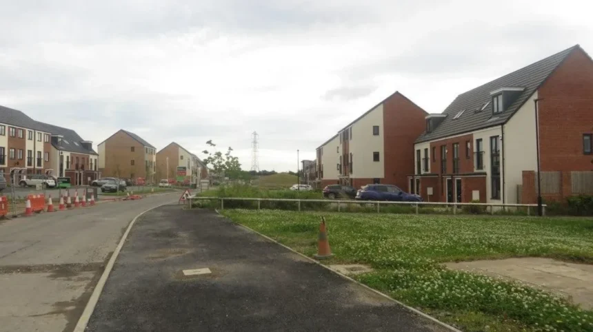
Cycling around North Newcastle connects modern residential communities, historic villages, green corridors and the established streets of Gosforth. The area’s cycling landscape reflects Newcastle upon Tyne’s development from a settlement shaped by agriculture and country estates into a major regional city with expanding suburbs, transport infrastructure and planned residential districts.
- How Did North Newcastle Develop from Rural Land into a Modern Cycling District?
- What Makes Newcastle Great Park an Important Starting Point for a Cycling Journey?
- Which Cycling Route Connects Great Park with Gosforth?
- Stage one: Start on the Great Park cycle network
- Stage two: Connect towards Kingston Park Road
- Stage three: Continue towards Gosforth
- How Does Gosforth High Street Reflect Newcastle’s Transport History?
- Which Historic Places Can Cyclists Explore Near Gosforth?
- South Gosforth and St Nicholas Church
- Gosforth Park and the country-estate landscape
- Gosforth Nature Reserve and wildlife conservation
- How Did Public Transport and Suburban Expansion Shape Cycling in Gosforth?
- From mining communities to residential suburbs
- The role of the Metro and interchange journeys
- Why modern cycleways matter
- What Should Cyclists Know About Route Safety and Accessibility in North Newcastle?
- Check the route before departure
- Choose a route that matches your experience
- Consider accessibility beyond the riding surface
- How Can Cycling Connect North Newcastle’s History with Its Modern Attractions?
- What Is the Future of Cycling Between Great Park and Gosforth?
- Connecting new housing with existing neighbourhoods
- Protecting historic and natural environments
- Why route information needs regular updating
- Exploring North Newcastle from Great Park to Gosforth
For Newcastle Times, this guide explores the geography, historical development and heritage of cycling routes between Newcastle Great Park and Gosforth. It explains how the surrounding landscape changed, identifies significant local places, and examines how present-day paths connect residential neighbourhoods with parks, shopping streets and historic settlements.
The route is particularly relevant to local residents, recreational cyclists, visitors and anyone researching the relationship between Newcastle’s urban expansion and its surviving green spaces. The focus is North Newcastle, with Great Park as the northern starting point and Gosforth as the principal southern destination.
How Did North Newcastle Develop from Rural Land into a Modern Cycling District?
North Newcastle developed through centuries of agricultural settlement, estate management, industrial expansion and suburban growth. Great Park represents recent planned development, while Gosforth preserves evidence of older rural settlements, historic roads, coal mining and nineteenth-century residential expansion.
From agricultural settlements to expanding suburbs
Before modern residential development, much of North Newcastle consisted of farmland, estates, small settlements and routes connecting Newcastle with communities farther north. Gosforth developed gradually around established roads, farms, religious sites and landholdings. Its history reflects the wider transformation of the North East during the medieval and industrial periods.
The Newcastle City Council Historic Environment Record identifies early archaeological evidence in Gosforth, including a flint flake discovered in 1959. Other discoveries include a Roman altar associated with North Gosforth Chapel and a Roman coin found during the nineteenth century. These finds demonstrate activity in the wider area during different historical periods, although individual discoveries do not establish continuous occupation at every location.
The first documentary reference to Gosforth dates to 1166. Historical records distinguish North Gosforth from South Gosforth, reflecting the development of separate settlements and landholding arrangements. Medieval tax records also identify residents in the area, providing evidence of established communities long before modern Newcastle expanded northwards.
How industrialisation changed the landscape
Industrialisation brought new economic activity to the Gosforth area. Coal mining became part of the local economy, with Gosforth Colliery operating during the eighteenth century before falling out of use by 1895. Coxlodge Colliery and other workings added to the area’s industrial history. Wagonways supported the movement of coal and connected industrial sites with wider transport networks.
These developments formed part of the wider industrial transformation of Tyneside, where coal production, manufacturing and transport influenced settlement patterns. Agricultural land gradually gave way to industrial facilities and new housing in suitable locations.
The historical landscape remains relevant to modern cycling because routes follow the geography inherited from earlier development. Roads, green spaces, settlement boundaries and transport corridors all influence how cyclists travel between Great Park and Gosforth today.

What Makes Newcastle Great Park an Important Starting Point for a Cycling Journey?
Newcastle Great Park is a large planned community established in 2001, combining housing, schools, business accommodation, public spaces and cycling infrastructure. Its dedicated paths provide practical connections within the development and towards Kingston Park Road and surrounding neighbourhoods.
The origins of Great Park
Newcastle Great Park is a major urban development situated north-west of Newcastle city centre, close to the A1. Development began in 2001 through a consortium involving housebuilders Taylor Wimpey and Persimmon Homes, with support from Newcastle City Council. Other developers have also contributed to individual phases.
The development was planned as more than a residential estate. Its facilities include homes, schools, a business park, a town centre, community facilities, play areas and landscaped open spaces. The official Great Park website describes a wider site covering approximately 1,200 acres, with more than half allocated to landscaping and associated environmental improvements.
This planned layout distinguishes Great Park from older neighbourhoods that developed incrementally around historic roads, village centres and industrial employment.
Why cycling infrastructure matters here
Great Park contains a network of dedicated off-road cycle paths. The official development website identifies Brunton Lane as a largely traffic-free corridor through the community. It also identifies cycle paths alongside the Spine Road, connecting the A1 area with Kingston Park Road.
These paths give riders options for local journeys without requiring every trip to use a busy main road. They also connect residential areas with schools, shops, open spaces and public transport facilities.
The distinction between a cycle path and a general road is important. A dedicated cycle facility separates cyclists from motor traffic for at least part of a journey, while a shared path accommodates pedestrians and cyclists together. Riders should follow the signs displayed on the route and give pedestrians appropriate space.
Great Park’s infrastructure also reflects a wider planning objective: making everyday travel by bicycle more practical. Its position between residential areas and established transport corridors makes it a useful starting point for journeys towards Gosforth.
Which Cycling Route Connects Great Park with Gosforth?
A practical journey from Great Park to Gosforth follows available local cycle paths towards Kingston Park Road and continues through suitable signed connections towards Gosforth. The exact route depends on the starting street, destination and current path conditions, so riders should check an up-to-date regional cycle map.
Stage one: Start on the Great Park cycle network
Begin at a suitable access point on the internal cycle network. Brunton Lane and the cycle paths beside the Spine Road are useful reference points because the Great Park development identifies both as cycling corridors.
Select the route according to your starting location. Great Park covers a substantial area, so the nearest access point depends on the residential street or facility where the journey begins.
Follow designated cycle signs and check junction layouts before crossing roads. Where a route changes from an off-road path to a street, reassess the traffic conditions rather than assuming that the protected section continues.
Stage two: Connect towards Kingston Park Road
The Great Park cycling information identifies the Spine Road paths as extending towards Kingston Park Road. This provides a useful reference corridor for planning a journey out of the development.
Kingston Park is also relevant because it contains shops and Metro connections. Great Park’s official cycling guidance identifies nearby facilities at Kingston Park and Brunton Park as destinations accessible by bicycle.
However, a route that reaches Kingston Park Road does not automatically provide a continuous traffic-free connection to every part of Gosforth. Riders should verify the next section, especially at road crossings, junctions and places where a cycle facility ends.
Stage three: Continue towards Gosforth
Gosforth is the principal southern destination for this journey. Its High Street provides access to shops, services and local public transport. The historic road corridor through Gosforth developed as an important northbound route from Newcastle, making the relationship between transport and settlement central to the area’s history.
For the final section, use the current Transport North East walking and cycling map to select a suitable connection. The regional map covers Newcastle and neighbouring authorities and allows users to display off-road cycling routes.
Route-planning note: This is a corridor-based guide, not a verified turn-by-turn route or a claim that every section is protected from traffic. Check the current map before departure and choose connections appropriate to the rider’s experience.

How Does Gosforth High Street Reflect Newcastle’s Transport History?
Gosforth High Street developed along an established northbound road corridor linking Newcastle with settlements farther north. Its surrounding buildings reflect nineteenth- and early-twentieth-century suburban expansion, while its continuing commercial role connects historic movement patterns with modern local travel.
The Great North Road and the growth of Gosforth
The historical record identifies the Great North Road, which runs through Gosforth and forms the present High Street, as an old route northwards from Newcastle. Its origins are possibly Roman, and it was certainly an important route during the medieval period. The distinction matters: the road’s medieval significance is documented, but its precise Roman origins are not established with the same certainty.
Roads often shaped the location of settlements, shops and services. Gosforth’s position on a major northbound corridor helped maintain its relationship with Newcastle while surrounding land changed from agricultural use to housing and commercial development.
Cyclists travelling through the area encounter this inherited geography. The High Street remains a prominent destination, but it functions within a much larger modern transport network that includes roads, public transport and cycling connections.
Historic architecture and conservation
Gosforth contains a recognised conservation area. Newcastle’s Historic Environment Record states that the Gosforth Conservation Area was designated in April 2002. It highlights architectural styles including High Victorian, Queen Anne Revival and Edwardian buildings. The historic streetscape also includes traditional commercial premises and residential properties.
The conservation designation recognises the special character of the area and brings planning considerations intended to protect it. It does not mean that every building is listed individually, or that every street feature dates from the same period.
For cyclists, the historic centre offers a chance to observe how an older transport corridor developed into a suburban commercial district. When stopping to examine buildings, use designated parking locations and avoid obstructing pavements or shop entrances.
Which Historic Places Can Cyclists Explore Near Gosforth?
Gosforth’s heritage includes medieval settlement evidence, historic religious sites, former coal-mining landscapes, country estates and a long-established road corridor. These features reveal how agriculture, industry, recreation and suburban development shaped North Newcastle across different periods.
South Gosforth and St Nicholas Church
South Gosforth developed around an established settlement associated with St Nicholas Church. The Historic Environment Record identifies the church and the former village area as important parts of the settlement’s historical geography. The area was relatively small in the nineteenth century, with a farm, school and a limited number of dwellings recorded on the first Ordnance Survey map, surveyed around 1855.
The site’s history helps explain the difference between older village centres and the later residential districts surrounding them. Modern Gosforth incorporates places that once had distinct settlement identities.
Visitors should confirm public access and respect the fact that churches and their grounds are places of worship and, in some cases, active burial sites.
Gosforth Park and the country-estate landscape
Gosforth Park originated as a country estate during the eighteenth century. Its historical environment includes an icehouse, recorded in Newcastle’s Historic Environment Record. The site later became associated with Gosforth Park Racecourse, which relocated from Newcastle’s Town Moor in 1882.
The history of the park demonstrates how land use changed from estate management and rural recreation to organised public entertainment and conservation. These uses form part of the broader story of North Newcastle’s changing relationship with open land.
A ride in the wider Gosforth area does not automatically provide access to the estate’s private or restricted sections. Check current access arrangements before planning a visit to any particular attraction.
Gosforth Nature Reserve and wildlife conservation
Gosforth Nature Reserve provides a further example of heritage extending beyond buildings and monuments. The Natural History Society of Northumbria records that conservation efforts began in 1924, when W. E. Beck leased shooting rights around the lake to protect birdlife. In 1929, the society formally took over the reserve under a lease arrangement.
The reserve’s history shows how local naturalists and conservation organisations helped protect wildlife within an expanding urban area. Monitoring of birdlife began in 1947, and the site later received recognition as a Site of Special Scientific Interest in 1970.
The reserve is not simply a cycling attraction. Access rules and conservation requirements take priority, and cyclists should not enter restricted nature areas or assume that internal wildlife paths are open to bicycles. The surrounding public cycle network can be combined with a separately planned visit where public access is permitted.
How Did Public Transport and Suburban Expansion Shape Cycling in Gosforth?
Gosforth’s growth accelerated as residential development, industrial employment and transport services reshaped North Newcastle. Historic roads, public transport corridors and newer cycle facilities now serve different travel needs, allowing residents to combine cycling with access to shops, schools and the wider city.
From mining communities to residential suburbs
The transformation of Gosforth did not occur in a single phase. Earlier settlements existed around farms, churches and landholdings. Industrial activity subsequently brought coal mining and associated transport infrastructure. From the late eighteenth century into the early twentieth century, residential development spread across previously undeveloped agricultural land.
The Gosforth Conservation Area character statement describes the area’s substantial development during this period. Buildings associated with the Victorian and Edwardian eras provide physical evidence of changing housing demand and the growth of a residential population connected to Newcastle.
This transition affected how people moved around the district. Historic roads continued to serve local journeys, while public transport and new streets supported a growing suburb. Modern cycling facilities now form another part of this transport history.
The role of the Metro and interchange journeys
Newcastle’s Metro system provides a way to combine bicycle travel with public transport. Great Park’s cycling guidance identifies cycle parking at local Metro stations as a facility supporting longer journeys.
For a rider travelling from Great Park, an interchange can reduce the amount of cycling needed to reach a destination beyond Gosforth. The practical value depends on the station, cycle-parking availability, service arrangements and the rules that apply to carrying bicycles on Metro trains.
Check current operator guidance before planning a combined journey. Cycle parking and permission to take a bicycle on a train are different facilities, and one does not guarantee the other.
Why modern cycleways matter
Newcastle City Council has identified walking and cycling as important elements of its transport strategy. Its published cycling information describes investment in new routes and efforts to make everyday journeys easier for people of different ages and abilities.
Dedicated infrastructure can connect homes with schools, local centres and public transport. It also supports journeys that do not require a car for every stage. However, a network’s usefulness depends on continuity, safe crossings, maintenance and clear wayfinding.
The Great Park–Gosforth corridor illustrates this planning challenge. Local paths provide important links, but riders still need to identify suitable connections between individual facilities. A route is only as practical as its least convenient or least safe section.
What Should Cyclists Know About Route Safety and Accessibility in North Newcastle?
A suitable Great Park–Gosforth cycling journey depends on current path conditions, road crossings, rider experience and destination access. Official regional mapping helps identify off-road facilities, while route checks, visible equipment and considerate riding improve the experience for cyclists and pedestrians.
Check the route before departure
The Transport North East interactive walking and cycling map covers Newcastle, North Tyneside, Northumberland, Gateshead and other parts of the North East. Its mapping tools allow users to inspect route options and display off-road cycle routes separately.
Use the map to check the full journey rather than only the starting and finishing points. Look for gaps between cycle paths, difficult junctions, crossings and changes in the route’s surface.
Construction and maintenance also affect accessibility. Great Park continues to develop, and its published development information identifies new housing, landscaping and cycle infrastructure as part of ongoing phases. Local arrangements therefore require checking close to the time of travel.
Choose a route that matches your experience
A confident adult commuter and a younger or inexperienced cyclist have different route-planning needs. Families should prioritise clear crossings, manageable distances, separated paths and places to stop safely.
A route described as traffic-free in one section does not establish that the entire journey is traffic-free. Where cycling facilities end, follow local signs and use an appropriate alternative instead of assuming that the pavement is available for cycling.
Before setting out, check that the bicycle’s brakes, tyres, lights and steering work properly. Wear a correctly fitted helmet, remain visible in poor light and obey road signs and traffic signals. On shared paths, reduce speed near pedestrians and give adequate warning before passing.
Consider accessibility beyond the riding surface
Accessibility includes more than the presence of a cycle lane. Path width, gradients, surface quality, barriers and crossing design influence whether a route is practical for different bicycles and mobility needs.
Families with trailers, riders using adapted cycles and people cycling with limited experience benefit from checking these details in advance. Online maps provide a starting point, but they do not always show every temporary obstruction or surface defect.
For a longer journey, identify safe stopping points and suitable public transport alternatives. Planning a shorter return route can also be useful when travelling with children or exploring unfamiliar neighbourhoods.
How Can Cycling Connect North Newcastle’s History with Its Modern Attractions?
Cycling connects North Newcastle’s historic settlements, conservation areas, parks and modern residential districts through a single form of local travel. A planned ride offers opportunities to examine architectural change, understand transport history and explore the relationship between urban growth and green space.
Linking local heritage with visitor experiences
A cycling journey between Great Park and Gosforth provides a framework for exploring how Newcastle expanded beyond its older urban core. Great Park illustrates twenty-first-century master-planned development, while Gosforth’s historic streetscape reflects earlier settlement patterns and nineteenth- and twentieth-century suburban growth.
These locations also connect with wider North Newcastle attractions. Gosforth Park, historic buildings, local shopping streets and surrounding green spaces provide different perspectives on the area’s development. Each location has its own access arrangements, so cyclists should check whether a particular attraction is open to visitors before including it in an itinerary.
To explore the wider area’s landmarks, parks and visitor attractions, consult our comprehensive [Insert Anchor Text for North Newcastle Things to Do and Visitor Guide Here] for itineraries and visiting information.
This contextual link creates a useful connection between the cycling guide and a broader visitor resource without changing the article’s primary focus on routes and local history.
Using cycling for educational visits
The Great Park–Gosforth corridor can support local history projects, geography lessons and independent research. Students can examine how housing, roads, open spaces and public transport relate to different periods of development.
A simple field study can compare the planned layout of Great Park with the historic road pattern and conservation-area buildings in Gosforth. Photographs, annotated maps and observations of land use provide evidence for understanding how neighbourhoods change over time.
Historic Environment Records, conservation-area statements and old Ordnance Survey maps offer additional research material. Newcastle’s Historic Environment Record is particularly useful for checking documented archaeological discoveries and historical sites. Researchers should distinguish recorded evidence from interpretation, especially when assessing the possible Roman origins of an old road or the significance of an isolated archaeological find.
Cycling-based educational visits should use public routes and approved access points. Historic buildings, nature reserves and religious sites require respect for their individual visitor rules.
What Is the Future of Cycling Between Great Park and Gosforth?
The future of cycling between Great Park and Gosforth depends on connected routes, safe junctions, well-maintained infrastructure and coordination between residential development and transport planning. Existing cycle paths provide a foundation, while ongoing development makes route continuity and public access important planning priorities.
Connecting new housing with existing neighbourhoods
Great Park’s development programme includes additional homes, schools, landscaped open spaces and cycle infrastructure. The developer’s published plans identify enhanced pedestrian and cycling connections as part of new development phases.
These connections are important because new housing generates journeys to schools, shops, workplaces and public transport. If cycling infrastructure stops at a development boundary, residents face a less convenient journey beyond it.
A connected network instead supports trips across neighbourhoods. For North Newcastle, this means ensuring that internal Great Park paths connect effectively with suitable routes towards Kingston Park, Gosforth and the wider regional network.
Protecting historic and natural environments
Transport improvements also require consideration of the area’s historic and natural assets. Gosforth’s conservation area contains architectural features that contribute to its local character, while Gosforth Nature Reserve protects wildlife and habitats.
Planning decisions should consider the effects of new infrastructure on heritage settings, green space and wildlife. Better connectivity does not require cyclists to enter restricted land or use sensitive habitats as shortcuts. Public routes and conservation objectives need to be considered together.
For local heritage organisations, residents and educators, the corridor provides a practical example of how transport planning interacts with preservation. Future development will be easier to evaluate when route maps, access information and planning documents clearly identify the relationship between new facilities and existing neighbourhoods.
Why route information needs regular updating
Cycle networks change as roads are resurfaced, construction projects progress and new paths open. A route description that was accurate at publication can become outdated after a junction alteration or temporary closure.
For this reason, Newcastle Times readers should use this article as a historical and geographical guide, then confirm current route details through the official Transport North East mapping service and relevant local information.
The long-term value of cycling infrastructure rests on more than the construction of individual paths. Clear signs, accessible crossings, maintenance and continuous connections determine whether people can use the network for everyday journeys.
Exploring North Newcastle from Great Park to Gosforth
Cycling between Newcastle Great Park and Gosforth reveals the relationship between the city’s past and present. Great Park represents planned twenty-first-century expansion, while Gosforth preserves evidence of medieval settlement, historic transport routes, coal mining, country estates and suburban development.
The area’s cycling infrastructure provides opportunities for recreation, local travel and educational exploration. Dedicated paths within Great Park, connections towards Kingston Park Road and the wider regional mapping network offer useful starting points for planning a journey. The precise route requires a current map check, particularly where off-road paths connect with public roads.
For history enthusiasts, the journey offers a way to study how land use and transport changed over time. For residents, it demonstrates the importance of connecting new neighbourhoods with established centres. For visitors, it provides a framework for discovering North Newcastle’s built heritage and green spaces responsibly.
Newcastle Times recommends checking current cycling maps, respecting conservation and access requirements, and treating the journey as both a practical trip and an opportunity to understand the development of North Newcastle.