

Chapel House, in west Newcastle upon Tyne, tells the story of how a largely rural landscape became an established residential suburb during the twentieth century. Its history connects Roman frontier archaeology, Northumberland’s agricultural heritage, the region’s coal industry and the expansion of post-war housing. The modern neighbourhood reflects changing approaches to town planning, family housing and urban growth.
- Where Is Chapel House and What Defines Its Historical Identity?
- What Was the Landscape Around Chapel House Like Before the Residential Estate?
- How Did Roman Britain Shape the History of Chapel House?
- What Does Milecastle 9 Reveal About Roman Life and Archaeology?
- How Did Coal Mining Transform Western Newcastle Before Chapel House Expanded?
- When Was Chapel House Built as a Modern Residential Suburb?
- How Did Housing Design and Local Planning Shape Chapel House?
- How Did Schools and Community Facilities Change Chapel House?
- How Can Researchers Preserve and Investigate Chapel House’s History?
- Why Does Chapel House Matter to Newcastle’s Wider History?
Understanding Chapel House requires looking beyond its present streets and residential estates. The surrounding landscape contains evidence of Roman Britain, historic farming, mining and the transport networks that supported Newcastle’s industrial development. The suburb’s planned housing also provides an important example of how Newcastle expanded beyond its older urban boundaries during the 1960s and early 1970s.
This historical guide for Newcastle Times examines Chapel House’s origins, its Roman archaeological connections, the industrial landscape that preceded residential development, the people and planning decisions behind its growth, and the features that preserve its local heritage today.
Where Is Chapel House and What Defines Its Historical Identity?
Chapel House is a residential suburb in western Newcastle upon Tyne, Tyne and Wear, England. Its modern identity emerged through twentieth-century housing development, while nearby Roman archaeological remains and older agricultural landscapes connect the neighbourhood to a much longer regional history.
Chapel House lies approximately five miles from Newcastle city centre, within the city’s western suburban area. It sits close to Chapel Park, West Denton, Westerhope and Blucher. These neighbouring districts share a landscape shaped by farming, coal mining, road construction and expanding residential development.
The name Chapel House also appears in historical records relating to other places. These references require careful distinction. The modern Chapel House estate in Newcastle is not the same building as the historic Chapel House in Westoe, South Shields, which dates to approximately 1808 and is recognised for its architectural significance.
Chapel House is best understood as a planned residential estate rather than an ancient village with a documented, continuous settlement history extending to the medieval period. Its present streets and housing largely reflect the urban expansion of the 1960s and early 1970s.
However, the land beneath and around the estate has a considerably older history. The course of Hadrian’s Wall, Roman military installations, agricultural holdings and the industrial landscape of the Newcastle coalfield all provide context for understanding how this part of the city developed.
The suburb therefore represents two connected historical subjects: the ancient frontier landscape and the modern transformation of Newcastle’s western outskirts.
What Was the Landscape Around Chapel House Like Before the Residential Estate?
Before large-scale suburban construction, the Chapel House area formed part of a landscape of farmland, rural settlements, historic routes and coalfield activity. These land uses supported local communities and connected western Newcastle with the wider Northumberland countryside and industrial economy.
For centuries, the outskirts of Newcastle consisted of fields, farms, lanes and scattered settlements rather than continuous urban development. Agricultural land supplied food and other resources to communities around Newcastle, while roads connected farms and villages to markets and neighbouring districts.
The historic settlement pattern differed substantially from the modern suburb. Instead of rows of houses, schools, shops and residential roads, the countryside contained working holdings and open land divided by field boundaries and established routes.
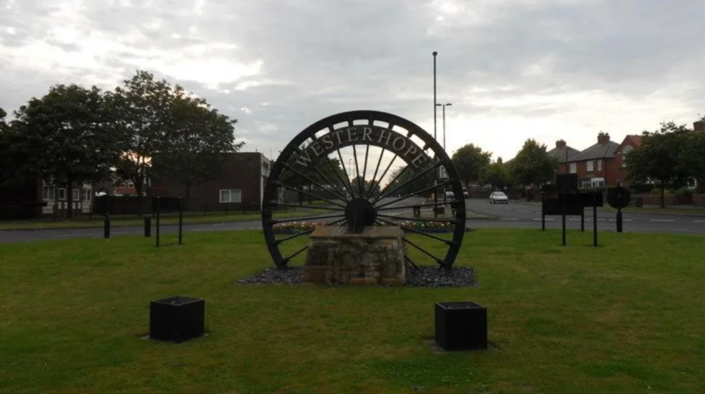
Neighbouring Westerhope offers important context for this earlier landscape. Its development included agricultural settlement and later coal mining, particularly after workable coal reserves encouraged industrial growth during the Victorian period.
Land ownership and farming practices influenced how the countryside was organised. Field boundaries, access tracks and established roads determined how land was cultivated and transported. Later developers inherited a landscape already shaped by centuries of human activity.
The area was not historically isolated. Newcastle’s expansion connected outlying settlements increasingly closely with the urban economy. As the city’s population and housing requirements changed, agricultural land became a potential location for new residential development.
This transition did not happen everywhere at once. Older villages retained elements of their previous character while newer housing estates appeared nearby. Chapel House’s twentieth-century layout reflects this process of expansion rather than an uninterrupted growth from a medieval village centre.
Historic maps are especially useful for investigating this transformation. Estate maps and successive Ordnance Survey editions help researchers compare former field boundaries, roads, buildings and later residential streets. Newcastle’s local history resources and Tyne & Wear Archives preserve records that support this type of research.
How Did Roman Britain Shape the History of Chapel House?
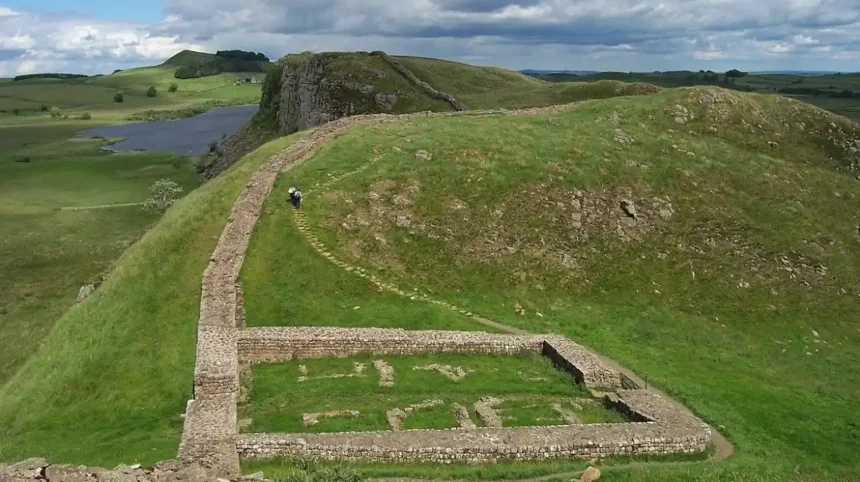
Roman military organisation left an important archaeological legacy near Chapel House through Milecastle 9 on Hadrian’s Wall. Excavations identified its dimensions, gateways and construction remains, connecting the modern suburb with frontier defence during Roman occupation of northern Britain.
The Roman period provides the area’s most significant ancient historical connection. Hadrian’s Wall was a frontier system built across northern England during the second century AD under the Roman emperor Hadrian, whose reign lasted from AD 117 to 138.
The wall formed part of a wider military landscape. Its components included forts, milecastles, turrets, defensive ditches and associated roads. These structures supported the movement of troops, communication and the management of passage across the frontier.
Milecastle 9, recorded in Newcastle’s Historic Environment Record under HER number 214, stood at Chapel House. A milecastle was a small fortified installation positioned at regular intervals along Hadrian’s Wall. Its gateways controlled movement through the wall, while its internal space accommodated a military garrison.
The site was recognised by the antiquarian John Horsley before archaeologists established its position more precisely in 1928. The North of England Excavation Committee investigated the remains, and E. Birley directed further excavation in 1929.
The recorded internal dimensions measured approximately 60 feet from north to south and 48 feet 10 inches from east to west. Archaeologists identified substantial wall foundations, remains of the northern gateway, an internal building and a paved sandstone surface near the southeastern corner.
The excavations also recorded evidence of stone removal. This process, known as stone robbing, involved taking masonry from abandoned buildings for reuse elsewhere. It explains why parts of the original structure survived only as foundations.
The site’s construction layers also attracted archaeological attention. Investigators identified deposits beneath the milecastle extending to a recorded depth of at least 4.5 metres. The origin and interpretation of these deposits were not conclusively established in the site record, which considers possibilities including a prepared building platform or earlier occupation.
The evidence places Chapel House within the Roman frontier’s physical geography. It does not establish that a Roman town occupied the location of the modern estate. The surviving archaeological record instead demonstrates a military installation within a larger defensive network.
What Does Milecastle 9 Reveal About Roman Life and Archaeology?
Milecastle 9 reveals how Roman frontier installations combined defensive architecture, controlled access and internal buildings. Its excavated foundations, inscribed stones and occupation evidence help archaeologists reconstruct military activity, although the available remains do not establish every detail of daily life.
The excavation record provides more than a location on a map. It documents the physical organisation of a Roman military structure and the methods archaeologists use to interpret damaged remains.
Several inscribed building stones were recorded during the 1929 investigations. These stones included Roman numerals associated with the milecastle’s masonry. The Tyne and Wear Historic Environment Record lists separate records for inscribed stones discovered in its foundations. The recorded stones are now lost, so the archaeological descriptions remain important evidence.
The internal arrangement also provides clues about the installation’s function. The northern gateway formed an important access point, while interior walls marked the position of a building within the enclosure. The sandstone paving and nearby ditch contributed to the interpretation of the structure and its immediate surroundings.
The archaeological record identifies evidence consistent with occupation during the second, third and fourth centuries. A coin of Emperor Valentinian, who ruled between AD 364 and 375, provides evidence relevant to the site’s later use. Researchers therefore considered the possibility that the milecastle remained occupied while Hadrian’s Wall continued to function as a frontier installation.
These findings require careful interpretation. A coin provides evidence of an object’s circulation or deposition, not a complete account of the people who lived at a site. Likewise, surviving foundations reveal construction methods but rarely preserve the full appearance of an original building.
The surrounding frontier also extended beyond the milecastle itself. Archaeological records document sections of Hadrian’s Wall, its ditch and the Vallum, a large earthwork system associated with the frontier, across the wider western Newcastle landscape. Parts of these features now lie beneath modern roads or developed land. Other sections survive as visible earthworks.
Milecastle 9 demonstrates why local archaeology matters. A residential suburb can occupy a landscape with internationally significant remains, even when the ancient structures are no longer visible at street level.
How Did Coal Mining Transform Western Newcastle Before Chapel House Expanded?
Coal mining transformed western Newcastle by creating employment, supporting industrial transport and encouraging settlement beyond the historic city. Nearby communities such as Westerhope and Walbottle illustrate how extraction reshaped the countryside before twentieth-century housing estates changed its physical character.
The Newcastle coalfield formed an important part of the North East’s industrial history. Coal supplied households, workshops, factories and transport systems, while mining created demand for labour and supporting infrastructure.
The western outskirts participated in this wider industrial economy. Westerhope developed substantially during the Victorian period as workable coal reserves encouraged industrial expansion. Mining also affected North Walbottle and neighbouring settlements, linking the countryside with the commercial and industrial life of Newcastle.
Coal production required more than underground workings. Pits needed access roads, equipment, labour and transport connections. Wagonways, which were tracks used to move coal in wagons, connected mining areas with markets and distribution points. Their routes formed part of the industrial landscape of western Newcastle.
These transport systems influenced the geography of development. Mining infrastructure introduced new routes and changed land use, while industrial settlements created a larger local population. The resulting landscape combined farmland, working-class housing, industrial buildings and transport corridors.
The closure of mines also changed the region. North Walbottle Colliery closed in 1968 after producing coal for many years. The Westerhope historical record reports that the pit extracted approximately 21.5 million tons of coal. It also records concern about the risk of further extraction undermining Newcastle Airport’s runway.
The end of mining did not erase the industrial past. Former mining land, altered ground levels, surviving routes and settlement patterns continued to influence the area. Some industrial traces disappeared under subsequent development, while others remained identifiable in historical maps and archaeological records.
Chapel House’s emergence as a residential estate therefore occurred within a landscape already transformed by industrial activity. The new housing did not simply replace untouched countryside. It followed earlier changes in employment, transport and settlement that had connected western Newcastle more closely with the city.
When Was Chapel House Built as a Modern Residential Suburb?
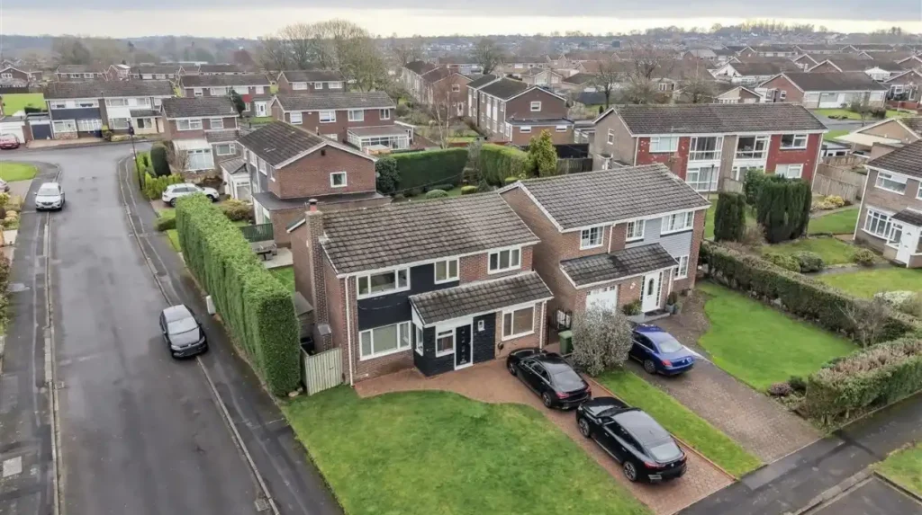
Chapel House developed primarily between 1964 and the early 1970s as a planned residential estate in west Newcastle. Its construction reflected post-war demand for modern housing, with residential streets and local facilities designed for an expanding suburban population.
The mid-twentieth century marked a major turning point in Chapel House’s history. Newcastle expanded beyond its older built-up districts as planners and developers responded to changing housing needs. Areas on the western edge of the city became locations for planned residential estates.
Available local historical summaries identify architect John T. Bell with the design of Chapel House Estate and date the development from 1964 into the early 1970s. The estate lies approximately five miles from the city centre.
The period after the Second World War brought substantial changes to British housing policy and residential expectations. Many households sought modern homes with more space, gardens and access to schools and everyday services. Suburban development offered an alternative to the dense terraces found in older urban neighbourhoods.
Chapel House reflects this approach through its predominantly low-rise residential character. Houses were arranged along suburban streets rather than within the compact street pattern of Newcastle’s historic centre. The resulting layout distinguished the estate from older settlements such as Westerhope and Walbottle, which retained evidence of earlier village and industrial development.
The estate’s construction also illustrates the relationship between architecture and social change. A new residential neighbourhood required more than individual houses. It needed roads, pedestrian access, educational facilities and connections to the wider urban area.
The development period extended across several years, so Chapel House did not appear as a complete suburb in a single event. Housing construction and the establishment of local services occurred progressively. This gradual process helped turn the estate from a building project into an established residential community.
The distinction between Chapel House and the nearby Chapel Park estate also matters. Both belong to Newcastle’s western suburban expansion, but they are separate neighbourhoods with their own development histories. Understanding that distinction helps researchers interpret planning records and avoid combining different construction phases into one chronology.
How Did Housing Design and Local Planning Shape Chapel House?
Chapel House reflects post-war suburban planning through its low-rise housing, residential streets and provision for everyday community needs. Its layout demonstrates the shift towards planned neighbourhoods that balanced private housing, local services and connections with Newcastle’s expanding road network.
The estate’s design belongs to a period when British planners increasingly treated housing as part of a wider neighbourhood system. Homes, schools, roads and community facilities needed to function together rather than as unrelated developments.
Architectural character provides useful evidence of these priorities. Detached and semi-detached houses, terraced properties and other low-rise residential forms occur across the wider Chapel House and Chapel Park area. Their distribution reflects the variety of housing types associated with suburban expansion.
Private gardens and individual entrances also distinguish much of the estate’s housing from older high-density urban development. These features reflect changing expectations about family life, domestic space and residential privacy during the twentieth century.
Planning decisions influenced the relationship between residential streets and major transport routes. The surrounding road network connects Chapel House with neighbouring districts and the wider Newcastle area. However, the modern street layout also intersects with the much older archaeological landscape associated with Hadrian’s Wall.
The estate’s development demonstrates a central feature of urban history: new neighbourhoods frequently emerge through the combination of public planning, private construction and changing household requirements. The physical appearance of Chapel House records these forces in its buildings and street pattern.
How Did Schools and Community Facilities Change Chapel House?
Schools and community facilities helped Chapel House develop from a housing estate into an established neighbourhood. Educational provision changed as local populations and school policies evolved, while shops, places of worship and healthcare services supported everyday life within the western Newcastle community.
Residential expansion requires services that support the people moving into new homes. Chapel House’s development therefore involved more than housebuilding. Schools and local facilities formed part of the neighbourhood’s evolution.
The estate previously contained Chapel House Middle School, which served approximately 500 pupils before its closure in 2005. Its closure followed changes to the organisation of education in outer west Newcastle, where the school system moved towards two-tier education rather than the earlier first, middle and high school arrangement. The former school site subsequently accommodated Knoplaw Primary School.
This change illustrates how educational buildings reflect wider administrative decisions. School sites can remain important community assets even when the institutions originally occupying them disappear. Their subsequent reuse provides evidence of changing educational needs and land management.
Community campaigns also influenced the neighbourhood’s development. In 2011, residents campaigned to protect Chadderton Field from proposed development. The field subsequently gained village-green status, becoming an important example of local participation in decisions about open space.
The case demonstrates the importance of distinguishing between private development land and spaces valued for community use. Open areas provide historical continuity within suburban environments and preserve places for recreation and local activity.
Shops, healthcare facilities, places of worship and transport services also contribute to Chapel House’s established character. Their development reflects the practical requirements of residents rather than a single architectural or historical event.
These facilities form part of the suburb’s living history. School closures, building reuse and campaigns to protect open land document how communities respond to changing population needs and planning priorities.
How Can Researchers Preserve and Investigate Chapel House’s History?
Researchers can investigate Chapel House through archaeological records, historic maps, planning documents, photographs and oral histories. Newcastle’s Historic Environment Record and Tyne & Wear Archives provide important evidence for studying Roman remains, former land use and twentieth-century suburban development.
The most reliable approach to local history combines different types of evidence. No single map, photograph or written record explains every stage of Chapel House’s development.
Newcastle’s Historic Environment Record documents known archaeological and historical sites across the city and the wider Tyne and Wear area. Its database contains more than 17,000 recorded sites, including monuments, historic landscapes, industrial locations and archaeological discoveries.
For Chapel House, researchers can begin with the records for Milecastle 9 and the adjoining sections of Hadrian’s Wall. These entries identify excavation reports, recorded dimensions, archaeological finds and earlier publications. They provide a foundation for investigating the ancient landscape.
Historic maps offer a complementary source. Comparing successive map editions reveals when roads appeared, how field boundaries changed and where residential streets replaced open land. Newcastle’s local history resources and Northumberland Archives provide routes into this type of research.
Tyne & Wear Archives preserves a wide range of documentary material, including maps, photographs, plans, council records and personal papers. Its catalogue helps researchers identify relevant collections before consulting original documents.
Oral history adds another dimension. Interviews with former residents, school pupils and people connected with local businesses can record memories of the estate’s early years. These accounts provide valuable evidence about everyday life, although researchers should compare personal recollections with documentary records wherever possible.
Preservation also requires attention to the surviving archaeological landscape. Construction, road improvements and changes in land use can affect buried remains. The Historic Environment Record helps planners and researchers identify known sites and assess the historical importance of development areas.
For visitors interested in the wider neighbourhood today, consult the Newcastle Times [Insert Anchor Text for Chapel House Things to Do and Visitor Guide Here] for local attractions, heritage-related visits and practical information about exploring the surrounding area.
The historical significance of Chapel House extends beyond individual buildings. Its story includes the preservation of archaeological evidence, the interpretation of historic maps and the recording of community memories before they disappear.
Why Does Chapel House Matter to Newcastle’s Wider History?
Chapel House matters because its history connects Roman frontier archaeology, Northumberland’s agricultural landscape, the coal industry and post-war suburban planning. These layers explain how Newcastle expanded westward and how successive generations transformed the area’s land, buildings and community life.
The suburb provides a useful case study in the relationship between ancient landscapes and modern urban growth. Milecastle 9 demonstrates the importance of Roman military infrastructure, while the surrounding archaeological records establish the wider frontier’s presence beneath and alongside the modern transport network.
The industrial period introduced another layer of change. Coal mining, wagonways and the growth of neighbouring settlements connected western Newcastle with the regional economy. The subsequent decline of mining created a different context for land use and residential expansion.
The construction of Chapel House Estate from 1964 into the early 1970s marks the area’s transition towards its modern residential identity. Schools, community facilities and later planning decisions show how the estate evolved beyond its original construction period.
These historical layers also explain why preservation matters. Archaeological remains provide evidence of ancient military organisation, while maps and photographs document changes that are less visible in the modern streetscape.
Future research into Chapel House benefits from collaboration between residents, historians, archaeologists, archives and local authorities. Better documentation of former buildings, school histories and residents’ experiences strengthens the historical record and supports informed planning decisions.
For Newcastle Times readers, Chapel House offers a clear example of how a suburban neighbourhood reflects much larger historical forces. Its development records changes in defence, industry, housing and community life across nearly two millennia.
Understanding that history gives the modern suburb a deeper context. Chapel House is not simply a residential area on Newcastle’s western edge. It is part of a landscape whose archaeological remains, industrial heritage and twentieth-century development collectively explain the growth of the city.