South Gosforth is an established residential area in Newcastle upon Tyne with roots extending into the medieval period. Its modern identity developed from an older village, agricultural land, coal mining, improved transport and suburban expansion. The area now forms part of the wider Gosforth district north of Newcastle city centre.
- What is the historical origin of South Gosforth?
- How did St Nicholas Church shape South Gosforth?
- How did coal mining transform South Gosforth?
- Why did South Gosforth become a residential suburb?
- What architecture survives in and around South Gosforth?
- How did transport change life in South Gosforth?
- What role do Gosforth Park and Gosforth Central Park play in the area’s history?
- What makes South Gosforth historically important today?
- How should the historical evidence be used when assessing South Gosforth as a place to live?
- How has South Gosforth changed from a medieval village to a modern Newcastle suburb?
Its historical importance is visible in St Nicholas Church, the former Gosforth Colliery landscape, surviving Victorian and Edwardian housing, historic streets and nearby Gosforth Central Park. Newcastle City Council also recognises the wider Gosforth Conservation Area for its architectural character, which includes High Victorian, Queen Anne Revival and Edwardian buildings.
The question of whether South Gosforth is the “best” place to live depends on the criteria being examined. History, architecture, transport, green space, housing character and access to Newcastle city centre provide different measures. A historical assessment therefore offers a more useful understanding of why South Gosforth developed into a prominent suburban neighbourhood.
What is the historical origin of South Gosforth?
South Gosforth originated as a medieval settlement recorded in 1166, developed around St Nicholas Church, agriculture and local landholding, and later expanded through coal mining, transport improvements and nineteenth-century suburban development north of Newcastle.
The earliest documentary reference to South Gosforth dates from 1166. The settlement was recorded as a member of the barony of Whalton, a medieval territorial holding associated with landownership and feudal administration. The village subsequently became divided between important local landholding families.
Two-thirds of South Gosforth was held by the Lisle family from the late twelfth century. The Heselrig family held the remaining third from the middle of the fourteenth century. These arrangements demonstrate that South Gosforth existed as a structured rural settlement centuries before its modern suburban character appeared.
The medieval settlement was positioned close to the site of St Nicholas Church. Historical evidence describes South Gosforth as a relatively small community. Four taxpayers were recorded in 1296 and five in 1312. These figures provide evidence of the settlement’s modest scale during the medieval period.
The village later contracted in size. By the time of the first Ordnance Survey mapping in the nineteenth century, South Gosforth consisted of a farm, a school and several dwellings around the church area. The historical record therefore shows a transition from medieval village to rural settlement before large-scale suburban expansion.
The archaeological record adds further depth. Gosforth has produced evidence of human activity extending beyond the medieval period. A flint flake discovered in 1959 represents the earliest recorded evidence of human activity in the wider Gosforth area. A Roman altar was found at North Gosforth Chapel, while a Roman coin was discovered during the nineteenth century.
These discoveries place South Gosforth and the wider Gosforth district within a much longer archaeological landscape. The evidence does not mean that the modern suburb existed during Roman Britain. It demonstrates that the wider locality has experienced human activity across several historical periods.
How did St Nicholas Church shape South Gosforth?
St Nicholas Church provided a long-standing religious and community focus for South Gosforth, with medieval origins, a rebuilt eighteenth-century structure, nineteenth-century alterations and later additions that preserve evidence of the settlement’s changing architectural and social history.
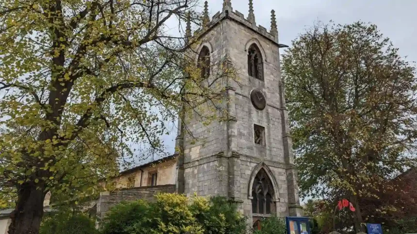
St Nicholas Church stands on Church Road and is one of the clearest surviving historical landmarks associated with South Gosforth. The site has medieval origins, although the present building incorporates later phases of construction.
The earliest recorded reference to the chapel dates to the late twelfth century. It was associated with Robert de Lisle and operated for a period as a free chapel with its own rector under the patronage of the de Lisle family. This religious foundation connected the settlement to wider medieval ecclesiastical structures.
By the seventeenth century, the chapel had experienced decline. In 1650 there was a recommendation that it should become the parish church of the district. By 1663, records described the building as having been unoccupied for two years and standing in ruins.
A description from 1715 recorded a stone building measuring approximately 11 by 8 yards, with a west tower. A new chapel was constructed in 1799. The precise relationship between the earlier medieval structure and the later building remains uncertain, but part of the eighteenth-century building survives within the present church.
The current Church of St Nicholas includes a 1799 tower and west end attributed to John Dodds. Architect John Dobson added further elements in 1820. Additional work followed in 1912–13 and 1950. Historic England lists the building at Grade II, recognising its architectural and historic interest.
The churchyard is also historically important. The first recorded burial dates to 1170. The five-acre churchyard contains gravestones, tombs and mature trees, including the tomb of the Brandling family, owners of the historic Gosforth Park estate.
For visitors interested in how the medieval settlement developed into the modern suburb, the churchyard provides a direct physical connection between South Gosforth’s medieval origins and its later urban history.
To experience this historic landscape in person today, consult our comprehensive for itineraries and visiting parameters.
How did coal mining transform South Gosforth?
Coal mining transformed South Gosforth during the nineteenth century by introducing deep-shaft extraction, industrial transport and employment, while the eventual closure of Gosforth Colliery removed the industrial landscape and created conditions for later residential suburban development.
Coal was one of the major forces behind Gosforth’s nineteenth-century transformation. Gosforth Colliery was located in South Gosforth and operated alongside other mining sites in the wider district.
The Gosforth Colliery record provides unusually detailed evidence of the engineering involved. The first shaft was sunk in 1825. Coal was not reached until 31 January 1829, when a productive seam was located. The High Main seam was affected by a geological dyke, requiring the shaft to reach 181 fathoms, approximately 331 metres.
Engineers then constructed a horizontal drift approximately 700 yards, or 640 metres, through solid rock to reach the coal seam. The undertaking demonstrates the technological and financial scale of early nineteenth-century deep mining in the Newcastle region.
The colliery had two shafts, a pumping engine and a wagonway approximately 3.5 miles long connecting the works with the River Tyne. Fixed engines hauled the wagons. The transport system linked South Gosforth’s industrial production with the wider coal economy of Tyneside.
Mining also affected the social history of the district. When a productive seam was finally reached in 1829, a subterranean celebration was held for workers. The underground room was approximately 1,100 feet, or 335 metres, below ground and measured around 15 feet, or 4.5 metres, across. Up to 300 workers attended the event.
Gosforth Colliery eventually declined. The site was marked as disused on second-edition Ordnance Survey mapping and was out of use by 1895. The Brandling family sold the colliery in the 1850s after financial difficulties forced the disposal of parts of its estate.
The physical evidence of mining has largely disappeared beneath later development. Historical mapping, archaeological records and documentary sources therefore remain important for understanding South Gosforth’s industrial phase.
Other mining sites existed around Gosforth. Coxlodge Colliery included the Bower Pit, Regent or Engine Pit and Jubilee or North Pit. Gosforth’s wider industrial landscape also included wagonways and associated transport infrastructure.
The disappearance of these industrial sites illustrates one of the defining processes in South Gosforth’s history: land once used for extraction and transport was progressively incorporated into a residential and suburban environment.
Why did South Gosforth become a residential suburb?
South Gosforth became a residential suburb as nineteenth- and twentieth-century urban growth replaced agricultural and industrial land with housing, roads, public facilities and transport infrastructure, connecting Gosforth increasingly closely with Newcastle and transforming the former village landscape.
The transition from rural settlement to suburb was gradual. South Gosforth retained its village identity during the early nineteenth century, while population growth and industrialisation increased pressure for additional housing.
The wider Gosforth area experienced rapid change during the nineteenth century. Mining created employment, while the Great North Road provided a major north-south route between Newcastle and settlements beyond the city. Newcastle City Council’s historical record identifies the route as an ancient highway, possibly Roman in origin and certainly important during the medieval period.
The Great North Road became Gosforth High Street. Its importance encouraged commercial and residential development along the route. The settlement known as Bulman Village emerged in 1826 around the modern Gosforth High Street.
Bulman Village was associated with the Bulman family and local electoral politics. Properties were built to qualify occupants as forty-shilling freeholders, meaning property holders meeting a historical qualification for the parliamentary franchise. The development reflected the political importance of property ownership before later electoral reforms expanded the electorate.
South Gosforth developed differently from the commercial centre around the High Street. Its growth remained closely associated with Church Road, St Nicholas Church and former industrial land.
By the late nineteenth century, roads including Woodbine Road, West Avenue, Ivy Road, Hawthorn Road and Causey Street had been established within the wider Gosforth urban area. Housing included two-storey brick or stone terraces with rear yards as well as larger detached houses.
The early twentieth century brought further expansion. Furzefield Road, Meadowfield Road and Brackenfield Road formed part of later development, while estates such as Graham Park introduced larger terraces and semi-detached villas.
This process created the architectural mixture now associated with Gosforth. Victorian terraces, Queen Anne Revival houses, Edwardian properties and later twentieth-century housing exist within the same broad suburban district.
Newcastle City Council designated the Gosforth Conservation Area on 26 April 2002. The designation recognised a collection of architectural types and styles considered distinctive within Newcastle. The conservation area includes High Victorian, Queen Anne Revival and Edwardian buildings.
What architecture survives in and around South Gosforth?
South Gosforth and the wider Gosforth district retain Victorian, Queen Anne Revival, Edwardian and later suburban architecture, with listed buildings, locally important structures and historic streets providing visible evidence of the area’s transition from village to planned residential suburb.
Architecture is one of the strongest surviving records of Gosforth’s suburban development. The buildings reveal changes in wealth, construction methods, domestic expectations and urban planning.
The Gosforth Conservation Area includes housing associated with High Victorian, Queen Anne Revival and Edwardian architectural traditions. The council’s assessment identifies this combination as unusually strong within Newcastle.
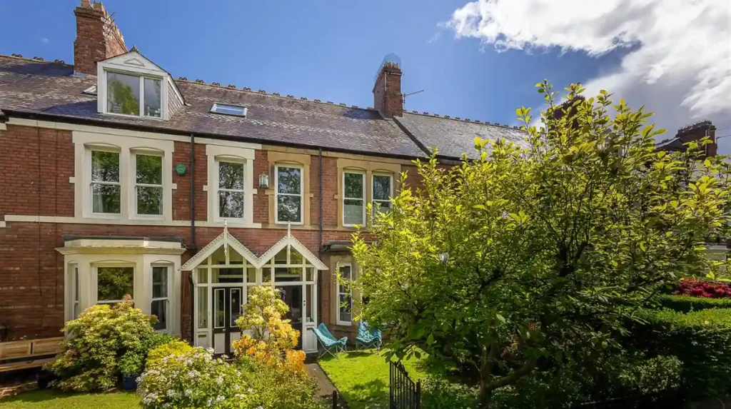
Queen Anne Revival architecture became particularly important in the late nineteenth and early twentieth centuries. The style often used varied brickwork, decorative detailing, projecting bays, irregular rooflines and carefully designed façades.
The Graham Park Estate provides an example of planned residential development. Architect William Hope of Hope and Maxwell Architects designed imposing terraces along streets including The Drive, Oaklands, Moor Place and Leslie Crescent. Large semi-detached villas also appeared along Graham Park Road and Elmfield Road.
The Poplars, dating from 1906, represents the Queen Anne Revival tradition. Brookside on Moor Crescent is associated with William Hope, while Andrew Kerr Tasker completed elements of the estate in a similar architectural language.
Other historic properties illustrate the diversity of nineteenth-century housing. Park Villas on Fernville Road consists of three mid-nineteenth-century double-fronted terraced houses. Their external appearance remains substantially intact, including bay windows, slate roofs and sash-window details.
The conservation area also includes important public and religious buildings. The Gosforth Conservation Area Management Plan identifies listed buildings including sections of The Drive, The Grove, High Street, Roseworth Terrace, All Saints Church, Trinity Church and Graham Park Road. It also identifies St Nicholas Churchyard and Gosforth Central Park as locally important heritage assets.
Historic architecture also survives as evidence of changing land use. Some large Victorian villas have been altered, converted or threatened by redevelopment. Newcastle’s conservation documents recognise the pressure created by subdivision, demolition, higher-density development and changing parking requirements.
This makes South Gosforth’s residential architecture relevant not only to house hunters but also to researchers studying Newcastle’s suburban history.
How did transport change life in South Gosforth?
Transport transformed South Gosforth by connecting the historic settlement to Newcastle’s expanding urban economy, with ancient road routes, industrial wagonways, tramways and later modern public transport supporting commuting, commerce, recreation and suburban growth.
Transport was central to South Gosforth’s development because the area occupied a strategic position north of Newcastle.
The Great North Road provided the principal historic road connection. Its long-distance function supported movement between Newcastle and northern settlements and helped establish the corridor that became Gosforth High Street.
Industrial transport had a different purpose. Gosforth Colliery used a wagonway approximately 3.5 miles long to move coal towards the Tyne. Fixed engines hauled the wagons, demonstrating the integration of South Gosforth into Tyneside’s industrial transport system.
Recreational transport also became important. When the racecourse opened at High Gosforth Park in 1882, direct public transport was initially inadequate. The nearest railway station was at Killingworth, while the existing tram service ended at Gosforth High Street.
The Gosforth Park Light Railway subsequently extended the tramway towards the racecourse. Special infrastructure was created to handle large race-day crowds, including additional sidings at Killingworth for special race trains. Parts of the historic tramway alignment remain identifiable, along with some tram-post bases.
Railways and tramways therefore performed more than a commuting function. They connected Gosforth with employment, recreation and commercial activity and helped make suburban living increasingly practical.
Modern transport continues this historical pattern. South Gosforth is served by Metro infrastructure and bus services, while Newcastle City Council identifies South Gosforth Metro as the nearest Metro station for Gosforth Central Park.
The area’s transport history demonstrates why its location became important. South Gosforth developed through successive improvements in movement rather than through a single redevelopment scheme.
What role do Gosforth Park and Gosforth Central Park play in the area’s history?
Gosforth’s parks preserve two different layers of local history: Gosforth Park developed from an eighteenth-century country estate into a racecourse, while Gosforth Central Park opened in 1932 as a public recreation space within the expanding twentieth-century suburb.
Gosforth Park represents the historic landscape of landownership, estate management and organised recreation. In 1566, Sir Robert Brandling acquired North Gosforth. In 1760, Charles Brandling moved the family seat from Felling to Gosforth and commissioned architect James Paine to design Gosforth House.
Around half of the township was subsequently incorporated into the park surrounding the house. Agricultural land was reorganised, trees were planted and estate infrastructure was created. The park included walls, gates, lodges, stables, walled gardens, a steward’s house and an ice-house.
The Brandling estate was sold in 1852. In 1880 the property was acquired for transformation into a racecourse. The High Gosforth Park Company developed the estate for racing and recreation. The first horse race at the new site took place on 10 April 1882.
The racecourse also hosted cycling, boating, skating and trotting. Greyhound coursing operated from 1881 until 1890. A grandstand was incorporated into the historic Gosforth House complex, and the site developed into a major recreational destination.
Gosforth House itself remains an important heritage structure. It is listed at Grade II* and underwent restoration after a fire in 1914. The fire was associated with suffragette activity, while restoration was completed in 1921.
The estate’s walled gardens also survive as archaeological and architectural evidence. Heated walls allowed fruit cultivation in the northern climate. One garden has been incorporated into a garden centre, while another remains disused.
Gosforth Central Park represents a different stage of development. It was created in 1932 at a cost of £10,000 and covers approximately three hectares. Much of its original design survives. The park contains a war memorial, bowling facilities, sports courts, grassed areas and children’s play facilities.
Newcastle City Council records more than 200 trees in the park, along with formal planting, a wildflower meadow and wildlife pond. The nearest Metro station is South Gosforth.
Together, these spaces show how Gosforth’s landscape changed from private estate management to organised public recreation.
What makes South Gosforth historically important today?
South Gosforth remains historically important because medieval settlement evidence, St Nicholas Church, industrial archaeology, Victorian housing, conservation controls, historic parks and twentieth-century public spaces survive within a modern Newcastle suburb.
The historical importance of South Gosforth does not depend on one surviving monument. Its value comes from the relationship between different periods and land uses.
St Nicholas Church provides evidence of medieval religious organisation. The churchyard preserves centuries of burial history. Gosforth Colliery records reveal the engineering and labour systems of nineteenth-century coal extraction. Historic houses record the rise of middle-class suburban development.
The conservation system provides another layer of protection. Newcastle City Council’s Gosforth Conservation Area was designated in 2002, with a management plan adopted in 2009. The planning framework seeks to preserve or enhance the area’s architectural character while managing the pressures created by redevelopment and changing residential requirements.
The conservation area contains listed buildings and locally listed assets. Newcastle City Council’s documentation records 49 Grade II listed buildings within the conservation area and nine sites on the local list in its conservation profile.
Planning controls are particularly relevant to understanding the modern residential environment. Parts of South Gosforth fall within Newcastle’s Article 4 Direction areas. The council states that an Article 4 Direction applies to parts of South Gosforth and regulates certain changes involving houses in multiple occupation.
This regulatory history matters because suburban character is shaped not only by the age of individual buildings but also by decisions about extensions, conversions, demolition, density and changes of use.
The area also retains evidence of its industrial past even where structures have disappeared. Historical maps, archaeological assessments and the Tyne and Wear Historic Environment Record preserve information about former pits, wagonways and other industrial sites.
This is particularly important for researchers. The physical disappearance of a colliery does not remove its historical significance. Archaeological records can preserve shaft locations, transport routes, land boundaries and industrial infrastructure.
For genealogists, churchyards and historical records provide another research pathway. St Nicholas Churchyard contains the Brandling family tomb and numerous historic gravestones. Parish records, burial evidence, maps and land records help reconstruct the social history of the district.
For architectural historians, the surviving residential estates provide evidence of how Newcastle expanded northwards during the Victorian and Edwardian periods.
How should the historical evidence be used when assessing South Gosforth as a place to live?
South Gosforth’s historical evidence shows a mature suburb shaped by medieval settlement, coal mining, transport, architectural expansion and public recreation; assessing its residential character requires considering these documented features alongside present-day housing, accessibility, green space and conservation requirements.
The phrase “best place to live” does not have one historical definition. Different residents assess neighbourhoods according to different requirements. South Gosforth’s historical record provides measurable characteristics rather than a universal ranking.
For people interested in heritage, the area contains several layers of documented history. St Nicholas Church has medieval origins. The churchyard contains recorded burials dating from 1170. Gosforth Colliery provides evidence of nineteenth-century industrialisation. Historic residential streets record the development of suburban Newcastle.
For architecture enthusiasts, the wider Gosforth Conservation Area contains Victorian, Queen Anne Revival and Edwardian buildings. The survival of terraces, villas, churches and planned estates creates a substantial architectural record.
For people interested in green space, Gosforth Central Park provides a three-hectare public park created in 1932, while the wider Gosforth landscape retains historic connections to Gosforth Park and its former Brandling estate.
For transport users, the historical record demonstrates that connectivity has been fundamental to the area’s development for centuries. The Great North Road, colliery wagonways, Gosforth Park Light Railway and modern Metro services represent successive transport systems serving different stages of urban growth.
For property researchers, conservation status is important. Historic buildings can require greater attention to design, alterations and planning requirements. Parts of South Gosforth are also affected by Article 4 controls relating to houses in multiple occupation.
For educators and students, South Gosforth provides a compact case study in urban transformation. Its development demonstrates how medieval settlements became industrial communities and subsequently suburban neighbourhoods.
The sequence is particularly clear: medieval village, agricultural settlement, coal-mining district, transport-connected community, Victorian suburb, Edwardian expansion and modern residential area.
That sequence explains much of the area’s present physical character. Historic roads influenced later development. Former industrial land was absorbed into the urban landscape. Estates produced distinctive architectural neighbourhoods. Public parks introduced planned recreational space. Conservation policies now manage the surviving historic fabric.
South Gosforth’s history therefore remains directly relevant to its present identity.
How has South Gosforth changed from a medieval village to a modern Newcastle suburb?
South Gosforth changed through successive phases of settlement, landownership, religion, coal mining, transport, suburban housing and conservation, creating the layered neighbourhood visible today rather than a suburb built during one period or according to one development plan.
The transformation began with the medieval settlement recorded in 1166. South Gosforth was then a small rural community associated with landholding families and the church.
During the eighteenth and early nineteenth centuries, the locality remained strongly connected to agriculture and landed estates. Gosforth Park developed as a substantial estate under the Brandling family, while South Gosforth retained its village character.
Industrialisation altered this balance. Gosforth Colliery became an important local industrial site, with deep shafts, pumping machinery and wagonway connections to the Tyne. Coal mining created employment and strengthened the relationship between Gosforth and the wider industrial economy of Tyneside.
The nineteenth century then brought increasing residential expansion. Roads, commercial premises, churches, schools and housing gradually changed the physical landscape.
Transport reinforced this process. The Great North Road supported long-distance movement, while industrial wagonways and later tramways connected Gosforth with employment and recreation.
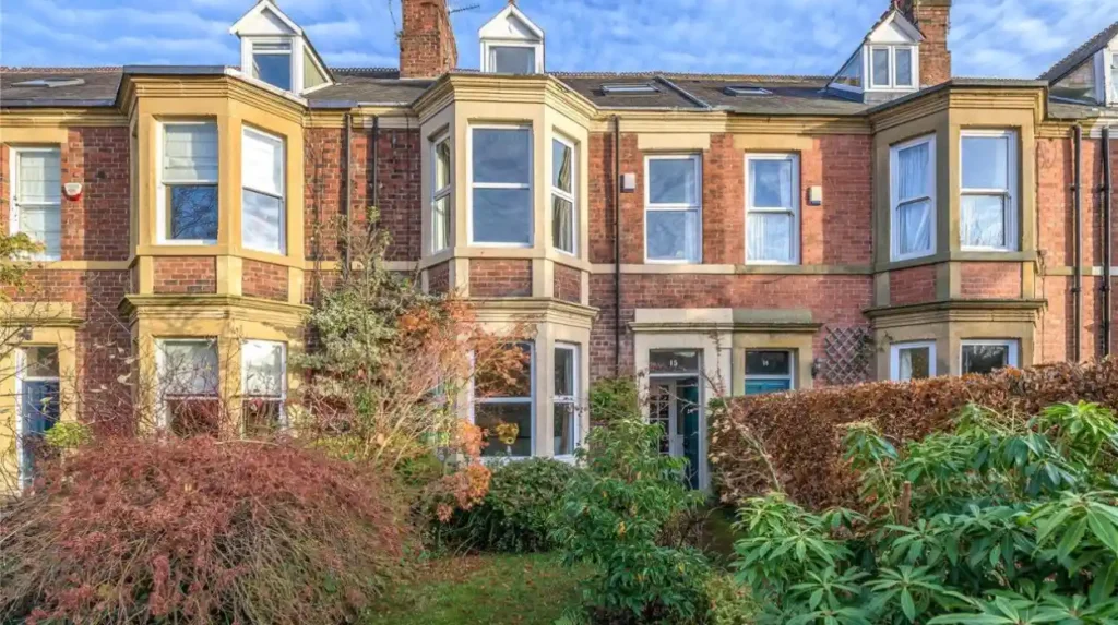
By the late nineteenth and early twentieth centuries, suburban architecture had become a defining feature. Terraces, villas and planned estates replaced sections of the older rural landscape.
The twentieth century introduced new public spaces and housing forms. Gosforth Central Park opened in 1932, while later development expanded the suburb further. Modern public transport now supports a residential district that is physically integrated into Newcastle.
The historical evidence therefore presents South Gosforth as a layered urban environment. Its current identity is the result of accumulated changes rather than a single historical event.
This explains why South Gosforth has significance for several types of researchers. Historians can study settlement and landownership. Archaeologists can investigate former industrial sites. Architectural researchers can examine suburban design. Genealogists can use churchyards and historical records. Educators can use the district to demonstrate urban change.
Its historical record also provides a framework for understanding present-day planning decisions. Conservation areas, listed buildings and locally significant sites exist because earlier phases of development remain visible and historically valuable.
South Gosforth is therefore best understood as a historic Newcastle suburb whose present character was formed over more than eight centuries. The medieval village, eighteenth-century estate landscape, nineteenth-century industrial economy, Victorian housing, Edwardian expansion and twentieth-century public parks all remain part of its historical identity.
The answer to whether it is the “best” place to live ultimately depends on the criteria applied. The historical evidence establishes something more specific: South Gosforth has a documented and unusually layered suburban history, with surviving architecture, green spaces, transport connections and heritage assets that continue to shape the neighbourhood today.