Newcastle Great Park is one of the largest planned residential developments in Newcastle upon Tyne. Located around three miles north-west of Newcastle city centre, close to the A1 Western Bypass and the wider Gosforth area, it combines housing, schools, employment space, retail facilities, landscaped areas and community infrastructure.
- What exactly is Newcastle Great Park?
- When did Newcastle Great Park begin and how has it developed?
- What was the historical landscape around Newcastle Great Park?
- Why was Newcastle Great Park planned as a large mixed-use community?
- How many homes are planned for Newcastle Great Park?
- What schools and community facilities serve Newcastle Great Park?
- What is Newcastle Great Park like for transport and access?
- What shops, services and employment facilities are available?
- How important are green spaces and landscape design at Newcastle Great Park?
- What historic features remain around the wider Gosforth area?
- What does Newcastle Great Park reveal about modern Newcastle?
- How should buyers assess Newcastle Great Park as a place to live?
- What is the long-term significance of Newcastle Great Park?
Its modern appearance can obscure the area’s older landscape history. Newcastle Great Park sits within a wider North Gosforth setting shaped by agriculture, estate landscapes, coal mining, transport routes and historic parkland. The development therefore represents both a contemporary housing project and another stage in the long transformation of Newcastle’s northern edge.
For prospective residents, the important question is not simply whether Newcastle Great Park is “worth the hype”. Its suitability depends on housing, transport, education, open space, services, employment access, development progress and the character of the surrounding historic landscape. Understanding how the area developed provides a clearer basis for evaluating its present-day role.
What exactly is Newcastle Great Park?
Newcastle Great Park is a large planned urban development north-west of Newcastle city centre, combining residential neighbourhoods, business space, schools, retail, recreation, landscaped land and transport infrastructure within a long-term masterplan.
Newcastle City Council describes Newcastle Great Park as a major development approximately three miles north-west of the city centre and close to the A1. The development includes a business park, housing, a town centre and schools.
The development is not a traditional historic town or village. It is a planned expansion of Newcastle’s urban area. Its identity comes from a combination of residential neighbourhoods, strategic open space, community facilities and new infrastructure.
The project is also unusually large in geographical terms. The Newcastle Great Park development website identifies a site of approximately 1,200 acres, with more than half of the land being landscaped and used for drainage, biodiversity and public-access improvements.
The original planning concept was broader than housebuilding. The 2006 Revised Master Plan established objectives covering approximately 2,500 dwellings, economic development, education, shopping, community facilities, recreation, environmental protection and transport.
This planned structure explains why Newcastle Great Park contains different neighbourhoods rather than functioning as a single conventional estate.
When did Newcastle Great Park begin and how has it developed?
Planning for Newcastle Great Park developed from Newcastle’s Northern Development Area proposals in the 1990s, with a masterplan approved in 1999 and construction beginning in 2001 before successive residential, educational, commercial and community phases expanded the settlement.
The origins of the project stretch back further than the first houses. Newcastle City Council’s planning history identifies the site as the Northern Development Area before it became known as Newcastle Great Park.
A planning brief was published in April 1998. Developers subsequently submitted proposals for a masterplan, followed by public consultation. The first masterplan received approval in 1999, while the council adopted a Design Code in November 2000.
The outline consent approved in October 2000 established the planning framework for subsequent development. The project was therefore conceived as a coordinated urban extension rather than a collection of unrelated housing applications.
Housebuilding began in 2001. The official development timeline records Warkworth Woods as being constructed between 2001 and 2005, followed by Melbury between 2002 and 2010.
Further stages followed. Greenside was developed between 2007 and 2015. Brunton First School was constructed between 2008 and 2009. East Moor Village developed between 2009 and 2012, while Brunton Village followed between 2010 and 2015.
The Community Centre was constructed between 2013 and 2014. Town Centre Phase 2 followed between 2016 and 2018. Later phases included Brunton West, Meadows and West Heath, while development at The Maples and Brunton Rise was planned through to 2034.
This timeline is important for understanding the property market. Newcastle Great Park is not a completed historic settlement with a fixed housing stock. It remains a planned development whose physical form continues to change.
What was the historical landscape around Newcastle Great Park?
The wider North Gosforth landscape developed through agriculture, estate ownership, coal mining, transport infrastructure and designed parkland, leaving archaeological and landscape evidence that predates the modern Great Park housing development by centuries.
The area’s history is closely connected with North Gosforth and Gosforth Park. Newcastle’s Historic Environment Record identifies Gosforth Park as a post-medieval landscape park associated with the Brandling family.
Sir Robert Brandling acquired North Gosforth in 1566. In 1760, Charles Brandling moved the family seat to the area from Felling and employed architect James Paine to design Gosforth House. Approximately half of the township was subsequently transformed into parkland surrounding the house.
The estate landscape incorporated trees, plantations, a lake, a boathouse, park walls, gates, lodges, stables, walled gardens, a steward’s house and an ice-house. These features demonstrate the scale of elite landscape design in eighteenth- and nineteenth-century North Gosforth.
Agricultural land was removed from production to create the park setting. This process illustrates how land use in the Newcastle northern fringe changed before modern suburban expansion.
The estate was sold in 1852 and later transformed again. In 1880, Gosforth Park was resold for conversion into a racecourse. The surviving historic landscape therefore records several phases of economic and social change rather than one continuous land use.
The wider area also contains evidence of industrial activity. Hazlerigg Colliery operated north of the modern development before its land was subsequently redeveloped as Havannah Nature Reserve. The historic Fawdon Wagonway also served local collieries during the nineteenth century, and part of its route survives as a public footpath.
This industrial history provides useful context for understanding Newcastle Great Park. The northern edge of Newcastle has repeatedly adapted to changing economic requirements, moving from agricultural and estate landscapes to mining, transport and eventually large-scale residential development.
Why was Newcastle Great Park planned as a large mixed-use community?
Newcastle Great Park was planned as a mixed-use urban extension because housing growth was intended to occur alongside employment, education, shopping, recreation, environmental improvements and transport infrastructure rather than as isolated residential construction.
The original planning objectives explicitly connected housing with infrastructure. The 2006 Revised Master Plan called for 2,500 homes together with 80 hectares of economic development land. It also required social and physical infrastructure to accompany housing growth.
This approach reflected a major principle of late twentieth-century and early twenty-first-century urban planning: large housing developments require schools, community facilities, transport connections, open space and employment opportunities.
The Newcastle Great Park masterplan also sought to protect and enhance the environment. Strategic open space and local open space were incorporated into the planning framework, while landscape and wildlife protection formed part of the stated objectives.
Transport was another central consideration. The planning framework sought to provide infrastructure and services capable of supporting journeys beyond private-car use. Later phases included cycle routes, bus services and road improvements.
The development’s physical design consequently differs from a conventional suburban housing estate. Streets, schools, retail facilities, sports areas, public spaces and landscaped drainage systems form part of a broader masterplanned structure.
The mixed-use principle also affects property evaluation. Residents assess not only the size and price of individual homes but also access to education, shops, recreation, employment areas and transport.
How many homes are planned for Newcastle Great Park?
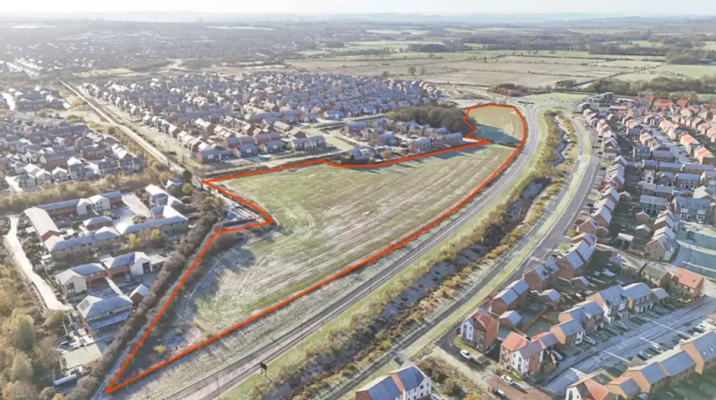
Newcastle Great Park was originally planned around 2,500 homes, while later expansion increased the overall programme, with Newcastle City Council approving 1,200 additional homes in 2018 and identifying completion of the wider development into the 2030s.
The housing target changed as planning evolved. The original masterplan established a 2,500-dwelling objective, divided across development cells. Later plans expanded the development beyond that initial number.
In December 2018, Newcastle City Council approved an expansion involving 1,200 new homes. Formal planning consent was subsequently issued after the required legal agreement was completed in 2019.
The approved expansion also included two schools. One was planned as a first school with capacity for 450 pupils, while the middle/secondary school was planned for up to 1,700 pupils. Together, the two schools were designed to support up to 2,000 pupils aged from four to sixteen.
The development timeline records The Maples and Brunton Rise within Cell A as a long-running phase scheduled from 2020 to 2034.
The scale and duration of construction are therefore fundamental to understanding the area. A buyer entering the market at different points can experience different levels of construction activity, infrastructure provision and neighbourhood maturity.
Newcastle Great Park’s continuing expansion also means that the physical environment around individual homes can change as later phases are completed.
What schools and community facilities serve Newcastle Great Park?
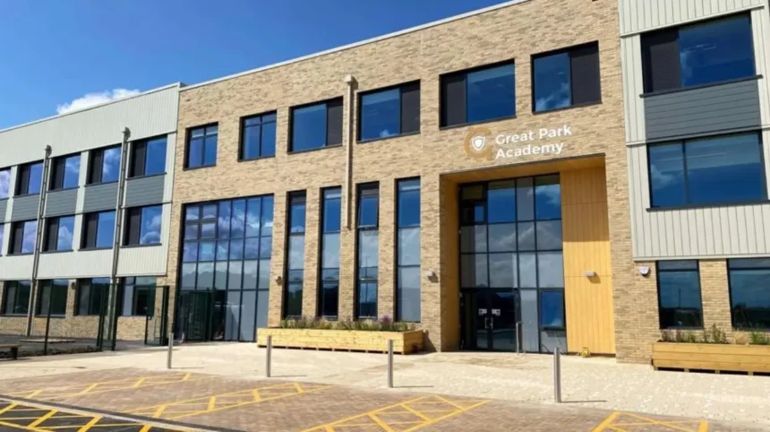
Newcastle Great Park has developed dedicated educational and community infrastructure alongside housing, including first schools, a community centre and Great Park Academy, which opened to pupils at its permanent site in September 2025.
Education formed part of the original planning strategy rather than being added after residential construction. The first schools were incorporated into the development as population increased.
Brunton First School was constructed between 2008 and 2009. Havannah First School subsequently became another education facility serving the growing community.
Newcastle City Council identifies middle-school and high-school provision through the Great Park development, alongside the expansion of Gosforth Central Middle School.
Great Park Academy opened at its permanent site in September 2025 after previously operating temporarily from Gosforth Academy at the Regent Centre.
Community infrastructure has developed alongside education. The Great Park Community Centre was constructed between 2013 and 2014. The development also includes sports and play pitches, while later planning phases provide additional playing fields and recreation infrastructure.
For families assessing the area, these facilities form part of the development’s core planning logic. They also demonstrate how the settlement has progressed from an early housing scheme into a more established residential community.
The presence of schools and community facilities is particularly important because Newcastle Great Park was designed to accommodate substantial population growth rather than simply provide commuter housing.
What is Newcastle Great Park like for transport and access?
Newcastle Great Park has direct strategic access to the A1 Western Bypass and Newcastle’s wider road network, while dedicated bus services, cycle routes and Park and Ride facilities form part of the development’s planned transport infrastructure.
The A1 is the major strategic transport feature of the location. Newcastle Great Park sits close to the A1 Western Bypass, providing road connections towards Newcastle and other parts of the North East.
The development was not planned solely around road access. Newcastle City Council’s expansion plans included new cycle routes and bus services to support additional households.
The development website also identifies dedicated public transport options and a Park and Ride facility. These services form part of the area’s wider transport infrastructure.
Road infrastructure has continued to evolve with construction. The official development timeline records Spine Road junction works between 2019 and 2022.
Transport access therefore has two dimensions. The first is regional connectivity through the A1 and surrounding road network. The second is internal mobility through bus services, cycle routes, walking connections and local roads.
This distinction matters for residents. A location can have strong regional road access while still requiring careful consideration of public transport routes, peak-period traffic and walking distances between different neighbourhoods.
The ongoing nature of Great Park also means transport infrastructure must be assessed against the development phase of a particular street or neighbourhood rather than treated as a static feature.
What shops, services and employment facilities are available?
Newcastle Great Park has developed a local town centre, business facilities, cafés, shops, professional services and community amenities, creating a service base within the wider residential development rather than relying entirely on Newcastle city centre.
The original masterplan identified economic development as a core objective. It allocated 80 hectares for economic development and sought to create employment opportunities alongside housing.
Commercial development became an important part of the site’s evolution. The official timeline records the construction of the Sage headquarters between 2004 and 2005.
The town centre developed through several phases. Town Centre Flats were constructed between 2009 and 2010, while Town Centre Phase 2 was completed between 2016 and 2018.
The current town-centre offer includes a supermarket, convenience retail, cafés, restaurants, professional services and other businesses. The development website lists businesses including Morrisons Great Park, One Stop, Plaza Cafe & Bistro and Newcastle Advanced Dentistry.
These services change the functional role of the area. Residents have access to everyday facilities without every journey requiring travel into central Newcastle.
Employment space also provides an important historical link to the original planning vision. Great Park was designed as a place where employment and housing would develop together.
The result is a settlement with a stronger internal economic structure than a purely residential estate, although the precise mix of businesses continues to change as the population and commercial centre develop.
How important are green spaces and landscape design at Newcastle Great Park?
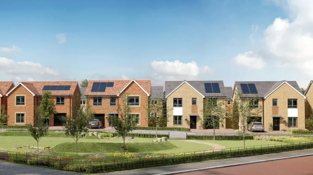
Green infrastructure is a central component of Newcastle Great Park, with extensive landscaped land, drainage features, biodiversity measures, open spaces, playing fields and public-access areas incorporated into the development’s long-term planning framework.
Landscape design was part of the development strategy from the beginning. The 2006 Revised Master Plan required strategic open space and local open space within the development framework. Environmental protection and improved recreation access were explicit objectives.
The present development website states that more than half of the approximately 1,200-acre site is being landscaped. It identifies landscape drainage, biodiversity improvements and public-access improvements as major components of the scheme.
The 2018 expansion plans also included new wildlife habitats, ecological enhancements, playing fields, a changing pavilion, car parking and public open spaces.
These features have practical functions beyond appearance. Sustainable drainage landscapes manage surface water, while planted areas provide habitat and help divide built-up neighbourhoods.
The green infrastructure also creates continuity with the area’s older landscape history. North Gosforth previously contained agricultural land, designed parkland, plantations, gardens and other managed landscapes. Modern landscaping represents a different planning purpose but continues the long association between development and deliberate landscape design.
For historians and heritage researchers, this provides a useful example of how contemporary urban expansion incorporates environmental infrastructure while occupying land with centuries of changing agricultural and estate use.
What historic features remain around the wider Gosforth area?
Historic remnants around the wider Gosforth landscape include Gosforth Park’s estate features, surviving walled gardens, historic landscape elements and archaeological records, while the broader area retains evidence of agriculture, coal mining, transport and nineteenth-century leisure development.
Gosforth Park provides some of the clearest historical evidence. Newcastle’s Historic Environment Record documents the former Brandling estate and its associated landscape features.
The walled gardens are particularly important. They were used to grow produce for Brandling House, with heated walls allowing fruit cultivation in the northern climate. One garden has been incorporated into a garden-centre setting, while another remains disused.
Archaeological recording was undertaken on the Gosforth Park walled gardens during the 2010s. The Historic Environment Record references building recording, evaluation and archaeological watching briefs undertaken between 2016 and 2017.
The former Gosforth House and associated parkland also demonstrate the social structure of the eighteenth-century landscape. The Brandling family belonged to the landowning elite associated with coal mining and regional political influence.
The transition to a racecourse in 1880 illustrates another major change. Leisure and sporting use replaced the earlier estate function, adding a new layer to the area’s history.
Industrial history is also significant. Former coal-mining landscapes and wagonway routes demonstrate the role of Northumberland and Tyneside’s extractive industries in shaping the northern outskirts of Newcastle.
The relationship between these remnants and the modern Great Park gives the area historical depth even though much of the current housing stock is less than three decades old.
To experience this historic landscape and the wider area’s attractions in person today, consult our comprehensive for itineraries and visiting information.
What does Newcastle Great Park reveal about modern Newcastle?
Newcastle Great Park demonstrates how Newcastle’s northern edge has changed from agricultural and industrial land into a planned mixed-use community, while retaining connections with the historic landscapes, transport routes, economic activities and environmental systems of North Gosforth.
The development represents a long-term urban planning experiment. Its construction began in 2001 and continues into the 2030s, giving it a development period of more than three decades.
Its history also demonstrates the changing scale of Newcastle’s urban growth. Earlier expansion frequently developed around established roads, villages, industrial sites and railway infrastructure. Great Park instead uses a comprehensive masterplan to coordinate residential areas, schools, commercial space, open land and transport.
The project’s scale reflects wider housing pressures. Newcastle City Council’s 2019 announcement described the additional 1,200-home expansion as part of the city’s response to population growth and housing demand.
The development also provides a case study in the relationship between housing and infrastructure. Schools, community facilities, transport improvements, retail provision and environmental works are being delivered alongside housing rather than treated as entirely separate urban systems.
For architectural and planning historians, the area offers evidence of early twenty-first-century suburban design. For genealogists, its significance is different: the population is comparatively recent, so family histories connected directly to Great Park itself largely belong to the twenty-first century. Research into older local families instead leads into the histories of Gosforth, North Gosforth, mining communities and the Brandling estate.
For educators, Newcastle Great Park provides a practical example of how land-use decisions transform landscapes over successive generations.
How should buyers assess Newcastle Great Park as a place to live?
A property assessment of Newcastle Great Park should consider housing design, development phase, transport, schools, local services, open space, employment access and future construction because the neighbourhood remains an evolving planned community rather than a finished historic settlement.
Property research in Newcastle Great Park requires attention to individual neighbourhoods. Different phases were built at different times, meaning homes vary in age, design, surrounding infrastructure and proximity to later construction areas.
The area’s education provision is now substantially more developed than during its early phases. Great Park Academy opened at its permanent location in September 2025, while Brunton First School and Havannah First School provide first-school provision.
Local retail has also developed progressively. The town centre provides everyday services, while employment facilities form part of the original mixed-use planning model.
Transport should be assessed according to the specific journey required. The A1 provides strategic road connectivity, while buses, cycle routes and Park and Ride facilities contribute alternative transport options.
Future development is another essential consideration. Newcastle City Council has approved substantial additional housing, while the official development timeline identifies construction extending towards 2034 in some areas.
Buyers should therefore distinguish between the established parts of Great Park and areas still undergoing construction. The experience of living in a mature neighbourhood differs from living beside an active development phase.
The historical context also adds another layer. Great Park forms part of a landscape that has repeatedly changed through estate management, agriculture, coal mining, transport, recreation and urbanisation. Its current housing environment is one stage in that longer process.
What is the long-term significance of Newcastle Great Park?
Newcastle Great Park is historically significant as a record of twenty-first-century urban expansion, showing how a large area of Newcastle’s northern landscape was reorganised around housing, employment, education, transport, environmental infrastructure and planned community facilities.
The project’s historical importance will become clearer as later phases are completed and future researchers can examine its planning documents, architecture, demographic change and environmental outcomes.
The original planning framework provides an unusually detailed record of the objectives behind the transformation. Housing numbers, employment land, infrastructure, open space and transport were defined within a coordinated planning structure.
The development also preserves evidence of changing approaches to urban sustainability. Landscape drainage, biodiversity measures, public open space and cycle routes demonstrate how environmental considerations became embedded within large-scale housing planning.
Its educational facilities provide another measure of community formation. The transition from early housing phases to dedicated first schools, community infrastructure and a permanent secondary-level academy shows the gradual development of a self-contained residential district.
The surrounding heritage creates an additional research dimension. The Brandling estate, Gosforth Park, walled gardens, former mining landscapes and historic transport routes demonstrate that the land around Newcastle Great Park has never had a single permanent function.
From an urban-history perspective, Newcastle Great Park therefore represents a transition from open and agricultural land to a large planned community. Its story connects local heritage with contemporary housing policy, infrastructure planning, environmental management and population growth.
The question of whether Newcastle Great Park is “worth the hype” is ultimately a matter of matching its documented characteristics with individual requirements. Its defining features are clear: strategic location, substantial housing, schools, commercial facilities, green infrastructure, planned transport connections and continued expansion. Those characteristics distinguish it from both historic Newcastle neighbourhoods and conventional suburban estates.