South Gosforth is a residential district in Newcastle upon Tyne where medieval settlement history, nineteenth-century industrial growth, Victorian housing, railway infrastructure and the modern Tyne and Wear Metro remain closely connected. Its transport history explains much of the area’s modern suburban character.
- How did South Gosforth develop from a medieval settlement into a Newcastle suburb?
- When did railway transport first arrive in South Gosforth?
- How did coal mining influence South Gosforth and Gosforth?
- Why was the railway important to South Gosforth’s suburban growth?
- What historic buildings survive around South Gosforth?
- How did Gosforth’s residential architecture change during the early twentieth century?
- What role did the Gosforth railway depot play in local transport history?
- When did the Tyne and Wear Metro transform commuting from South Gosforth?
- How does South Gosforth Metro affect modern commuting?
- Why does South Gosforth remain important to Newcastle’s suburban history?
- What can South Gosforth’s transport history tell future residents and researchers?
- How has South Gosforth’s history shaped its identity as a rental location?
- Why is South Gosforth’s history still relevant today?
The district sits within the wider historic parish of Gosforth, north of Newcastle city centre. South Gosforth developed from a small medieval settlement near St Nicholas Church into a railway-connected suburb. The transformation accelerated during the nineteenth and twentieth centuries as coal mining, housing development and public transport reshaped the landscape.
Today, South Gosforth is associated particularly with South Gosforth Metro station, the Metro depot, Church Road, residential streets and nearby Gosforth amenities. The station is not a completely new transport creation. It occupies a site with a railway history extending back to the nineteenth century.
Understanding this history explains why transport remains central to South Gosforth’s identity. The railway first connected the settlement with Newcastle and the wider North East network. The Tyne and Wear Metro later reused parts of this railway infrastructure and created a rapid urban transport system serving Newcastle, Gateshead, Sunderland and coastal communities.
How did South Gosforth develop from a medieval settlement into a Newcastle suburb?
South Gosforth began as a small medieval settlement recorded in 1166 and later expanded through farming, coal mining, railway construction and suburban housing, becoming increasingly integrated with Newcastle during the nineteenth and twentieth centuries.
The history of South Gosforth reaches considerably further back than the Metro. Newcastle City Council’s Historic Environment Record identifies South Gosforth as a medieval settlement. It was recorded in 1166 as part of the barony of Whalton.
The settlement had a small population structure during the medieval period. Four taxpayers were recorded in 1296 and five in 1312. The village was associated with landholding families including the Lisles and Heselrigs.
The original settlement stood close to St Nicholas Church. Its position is important because Church Road remains one of the clearest locations for understanding the historic core of South Gosforth.
By the time of the first Ordnance Survey mapping in the nineteenth century, South Gosforth remained relatively small. The settlement contained a farm, a school and several dwellings. An 1826 election recorded only six voters.
This rural settlement pattern changed substantially during the second half of the nineteenth century. Gosforth expanded as nearby villages and estates were absorbed into a growing suburban landscape.
The change was connected to Newcastle’s wider industrial expansion. Population growth increased demand for housing beyond the traditional city centre. Transport improvements made residential development further from the central urban area increasingly practical.
South Gosforth therefore represents a familiar North East urban-development pattern. A small historic settlement became part of a larger metropolitan area because transport, industry and housing development progressively reduced the physical separation between village and city.
When did railway transport first arrive in South Gosforth?
Railway transport reached South Gosforth during the nineteenth century, when the Blyth and Tyne Railway developed its Newcastle connection and opened Gosforth station in 1865, creating an enduring transport corridor later incorporated into the modern Metro system.
The railway transformed South Gosforth’s relationship with Newcastle.
Newcastle City Council’s Historic Environment Record identifies the historic Gosforth station as part of the Blyth and Tyne Railway. A Newcastle branch was constructed in 1865 under the chairmanship of Joseph Laycock, and Gosforth station opened that year.
This railway infrastructure preceded the modern Metro by more than a century.
The nineteenth-century railway served an area that was still developing from a rural settlement into an urban suburb. Railway access supported movement between Gosforth and Newcastle and formed part of the broader railway network serving industrial Tyneside.
The original railway station did not survive intact. The present Metro station replaced the 1865 railway station. However, an important physical remnant remains.
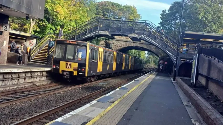
Newcastle’s Historic Environment Record states that the South Gosforth Metro station replaced the 1865 Blyth and Tyne branch station and that the surviving cast-iron footbridge dates from the earlier railway infrastructure.
This footbridge gives South Gosforth a direct physical connection with its Victorian transport history.
The surviving structure also demonstrates how modern transport infrastructure frequently develops through adaptation rather than complete replacement. A railway corridor created in the nineteenth century subsequently became part of a twentieth-century rapid-transit network.
For residents and visitors, the Metro station is therefore both a transport facility and a surviving point within a much longer railway landscape.
How did coal mining influence South Gosforth and Gosforth?
Coal mining formed an important part of Gosforth’s industrial history, with Gosforth Colliery and later Coxlodge workings contributing to the area’s nineteenth-century economy before suburban development progressively replaced industrial land uses.
Gosforth was affected by the industrialisation of Tyneside from the eighteenth century onward.
Newcastle’s Historic Environment Record records Gosforth Colliery as an eighteenth-century operation that had ceased working by 1895. Later workings included Coxlodge Colliery, Regent Pit and Jubilee Pit. These workings were associated with wagonway infrastructure used to move coal.
Coal mining changed both the economy and physical geography of the area.
Mining required shafts, transport routes, workers’ facilities and connections to wider industrial markets. Wagonways provided an early form of industrial transport before modern passenger railways became central to suburban mobility.
The industrial landscape eventually gave way to residential expansion.
This transition is important when examining modern South Gosforth. Many streets now associated with residential life developed within a landscape that had previously contained farms, estates, industrial sites and transport infrastructure.
The disappearance of mining did not erase its historical influence. The location of former industrial land, roads and railway corridors continued to shape subsequent development.
The transformation from coal-producing district to residential suburb also reflects wider changes across Newcastle and Tyneside. Heavy industry declined in importance while professional employment, retail, education and urban services became increasingly important to the regional economy.
South Gosforth’s transport accessibility supported that transition.
Why was the railway important to South Gosforth’s suburban growth?
The railway reduced South Gosforth’s physical separation from Newcastle, supporting suburban expansion by providing an established transport corridor between residential districts and the city’s employment, commercial and civic centre.
Transport infrastructure played a major role in the formation of Newcastle’s northern suburbs.
Before modern public transport, settlement patterns were strongly influenced by walking distances, agricultural land boundaries and existing roads. Railway construction introduced a different spatial structure.
South Gosforth benefited from a railway connection from 1865. The railway made regular movement between the Gosforth area and Newcastle more practical and connected the district to wider transport networks.
The effect was not simply about passenger journeys.
Railways also influenced land values, industrial logistics and patterns of urban development. New streets and housing estates developed around established routes and stations.
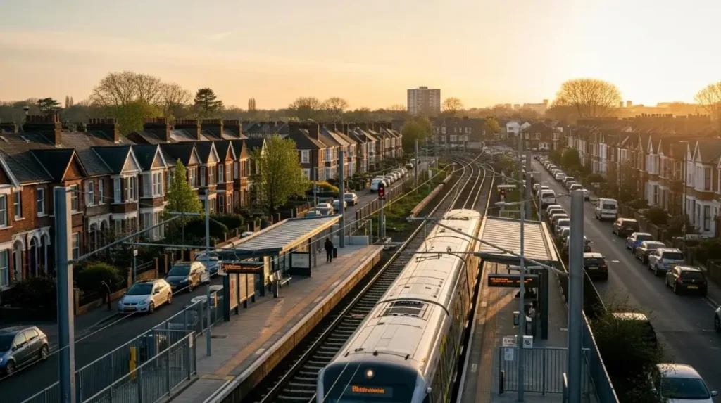
The Gosforth Conservation Area evidence demonstrates the scale of subsequent residential expansion. By the late nineteenth century, roads including Woodbine Road, West Avenue, Ivy Road, Hawthorn Road and Causey Street were established. Housing included two-storey brick or stone terraces, while larger detached properties developed along Kenton Road.
This architectural variety reflects different stages of suburban development.
Early terraces provided relatively compact housing. Later development included larger semi-detached houses and villas. The expansion continued into the twentieth century through additional housing estates.
The railway therefore formed part of a wider suburbanisation process rather than acting as an isolated transport improvement.
What historic buildings survive around South Gosforth?
South Gosforth and the wider Gosforth area retain historic churches, houses, terraces and transport structures that document the transition from medieval village to Victorian suburb and twentieth-century residential district.
St Nicholas Church is one of the most important historic buildings close to the historic centre of South Gosforth.
The present Grade II listed church incorporates a 1799 tower and west end designed by John Dodds after the demolition of an earlier church. John Dobson made additions in 1820, while further additions were made in 1912–13 and 1950.
The building therefore contains several layers of architectural history.
Its sandstone construction, slate roof, tower, nave, chancel and later additions demonstrate how parish buildings evolved alongside the communities they served.
The surrounding Gosforth area also contains surviving nineteenth-century residential architecture.
Historic England records Nos. 32–36 Gosforth High Street as a Grade II listed terrace dating from around 1840. The three houses are constructed in sandstone ashlar and retain features including sash windows and stone detailing.
Other historic residential buildings illustrate the expansion of the Victorian suburb.
The Newcastle Historic Environment Record identifies Park Villas on Fernville Road as three mid-nineteenth-century double-fronted terraced houses with bay windows, slate roofs and long rear gardens.
The architectural record therefore provides evidence for changing social and residential patterns.
The area contains examples of Victorian, Queen Anne Revival and Edwardian architecture. Newcastle City Council describes the Gosforth Conservation Area as having housing of these architectural types and identifies the quality of this housing as an important part of its character.
For anyone exploring the district today, the buildings provide physical evidence of the suburban expansion that followed the railway era.
To experience this historic landscape in person today, consult our comprehensive for itineraries and visiting parameters.
How did Gosforth’s residential architecture change during the early twentieth century?
Early twentieth-century development introduced larger semi-detached houses, decorated terraces and planned estates, extending the Victorian suburb and creating much of the architectural framework that still defines the wider Gosforth residential landscape today.
The early twentieth century brought another phase of suburban development.
Newcastle City Council’s conservation documentation identifies Furzefield Road, Meadowfield Road and Brackenfield Road as streets developed during the early twentieth century. Housing included richly decorated terraces and large semi-detached properties.
The Graham Park Estate provides another example.
Architect William Hope of Hope and Maxwell Architects was associated with the development, while James Frazer developed the estate through imposing terraces and large semi-detached villas. Streets included The Drive, Oaklands, Moor Place, Leslie Crescent, Graham Park Road and Elmfield Road.
The Poplars, dating from 1906, represents the Queen Anne Revival style found within the estate.
This period reflects changing expectations about suburban housing.
The expanding middle classes sought larger homes with gardens and greater separation from industrial urban centres. Newcastle’s northern suburbs provided space for these developments while retaining transport connections with the city.
The railway and later electric public transport helped sustain this relationship.
South Gosforth and wider Gosforth therefore became part of a metropolitan suburban system rather than remaining an independent village.
What role did the Gosforth railway depot play in local transport history?
The Gosforth railway depot became a long-term railway engineering and maintenance site, opening in 1923 and later becoming part of the Metro system, linking South Gosforth directly with more than a century of railway operations.
The Gosforth depot has an important place in the area’s transport history.
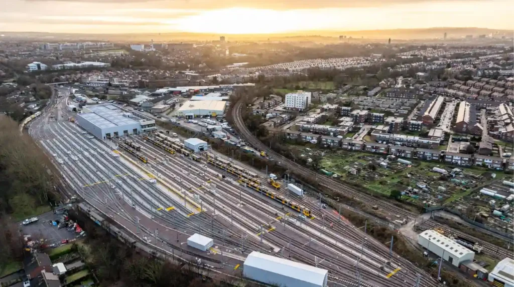
Nexus records that Gosforth depot opened in 1923 under the London and North Eastern Railway. It replaced a fire-damaged railway depot at Walkergate and continued the area’s association with railway rolling stock.
The depot later became part of the transition to the Tyne and Wear Metro.
The Tyne and Wear Passenger Transport Executive, now Nexus, took over the depot from British Rail in 1980. Its location allowed Metro trains to reach railway lines west towards Regent Centre and east towards Longbenton.
This geography helped make South Gosforth important to Metro operations.
The depot was not simply a maintenance site detached from the neighbourhood. It formed part of the physical infrastructure supporting passenger services across the region.
Its continuing use demonstrates the long-term importance of the Gosforth railway corridor.
In 2023, Nexus completed demolition work associated with the former depot buildings and continued developing a new maintenance hub for the modern Metro fleet. The organisation stated that the original depot had served railway rolling stock since 1923.
The modern facility therefore sits within a site with more than a century of railway history.
When did the Tyne and Wear Metro transform commuting from South Gosforth?
The Tyne and Wear Metro transformed South Gosforth’s commuting role after services began in 1980, converting an established railway corridor into a rapid urban transport route linking Newcastle with communities across Tyne and Wear.
The Tyne and Wear Metro emerged from a major public transport project during the 1970s.
Nexus records that the Passenger Transport Executive became responsible for developing what was then the UK’s largest urban transportation project. Construction began with major civil engineering contracts in 1974, including tunnels beneath Newcastle and Gateshead.
Two prototype Metro cars, numbered 4001 and 4002, began trials in 1975.
The first section of the Metro opened to passengers in August 1980. Nexus states that the system recorded more than 60 million passenger boardings during its first full year of operation.
South Gosforth became part of this new rapid-transit system.
The Metro retained important railway alignments while introducing electric urban transport and new operational infrastructure. This created continuity between the nineteenth-century railway system and the modern public transport network.
The historical significance is clear. South Gosforth did not receive transport access for the first time in 1980. Instead, an established railway corridor was adapted to meet the requirements of a modern metropolitan transport system.
This continuity explains why the district remains closely associated with Metro operations.
How does South Gosforth Metro affect modern commuting?
South Gosforth Metro provides direct rail-based access within the Tyne and Wear Metro network, giving residents a practical connection with Newcastle and other destinations while reducing dependence on private cars for many journeys.
The modern commuting role of South Gosforth is rooted in the network structure established during the Metro’s creation.
The station connects the residential district with Newcastle’s wider rapid-transit system. Its position also places residents close to other Gosforth transport corridors and local amenities.
For renters, transport accessibility is particularly relevant because rental housing often attracts residents who prioritise access to employment, education, shopping and leisure without requiring long-term car ownership.
South Gosforth’s transport advantage is therefore linked to both geography and historical infrastructure.
The station occupies a corridor already used for railway transportation since 1865. The modern Metro system expanded the functional importance of that corridor.
The station also benefits from connections through the wider Metro network rather than operating as an isolated suburban stop.
Travel patterns vary according to destination, timetable and interchange requirements. Exact journey times also change when timetables, engineering works or service patterns change. Current travel planning should therefore be checked against Nexus service information rather than relying on historic journey estimates.
Accessibility forms another part of the station’s practical importance. An Office of Rail and Road review of the Tyne and Wear Metro accessibility arrangements identified South Gosforth among stations where the route between platforms involves local roads rather than a direct accessible connection between platforms.
This distinction is relevant for passengers with mobility requirements and demonstrates why station-level accessibility information remains important when planning journeys.
Why does South Gosforth remain important to Newcastle’s suburban history?
South Gosforth remains historically important because its present residential identity preserves the physical relationship between medieval settlement, Victorian railway expansion, industrial activity, planned suburban housing and modern Metro infrastructure.
South Gosforth provides a compact example of Newcastle’s wider urban transformation.
The earliest documented settlement was medieval. Agricultural land and parish structures shaped the original landscape. Coal mining introduced industrial activity. Railway construction established a new transport corridor. Victorian and Edwardian housing expanded the suburb. The Metro later modernised the railway infrastructure.
Each stage left physical evidence.
St Nicholas Church represents the ecclesiastical history of the settlement. The surviving South Gosforth footbridge represents nineteenth-century railway construction. Victorian terraces and early twentieth-century houses document suburban expansion. The Metro station and depot represent modern public transport.
The wider Gosforth Conservation Area was designated in April 2002. Newcastle City Council identifies its architectural character as including High Victorian, Queen Anne Revival and Edwardian housing, together with the traditional Gosforth High Street.
The conservation designation provides a planning framework for protecting the area’s historic character.
Newcastle City Council’s conservation-area system includes profile sheets, character statements and management plans intended to identify the special qualities of designated areas and guide their preservation.
Historic buildings also receive statutory protection where they meet national listing criteria.
St Nicholas Church is Grade II listed. Gosforth contains other listed structures, including Grade II buildings and higher-grade heritage assets elsewhere within the wider area. Historic England records St Charles Roman Catholic Church on Church Road as a Grade II listed building dating from 1910–11 and designed by Charles Menart in the Decorated Gothic style.
These designations help preserve the architectural evidence needed to understand how Gosforth developed.
What can South Gosforth’s transport history tell future residents and researchers?
South Gosforth’s transport history demonstrates how long-term investment in railway corridors can shape urban growth, housing patterns and community identity across generations, making the district valuable for residents, historians, educators and researchers studying Newcastle’s suburban development.
The area’s historical value extends beyond individual buildings.
Transport infrastructure influenced where people lived, how workers travelled and how Newcastle expanded. The 1865 railway established an enduring corridor. The 1923 depot strengthened the area’s railway function. The 1980 Metro converted that historical corridor into part of a modern rapid-transit system.
The sequence also demonstrates how infrastructure can survive changes in technology and administration.
The original Blyth and Tyne Railway belonged to a nineteenth-century railway environment. Later railway organisations altered the network. British Rail subsequently operated the infrastructure. The Tyne and Wear Passenger Transport Executive took responsibility for Metro development and later Nexus operated the system.
The physical environment records these institutional changes.
For genealogical researchers, parish churches, historic maps, electoral records, railway records and property documentation provide different evidence types. South Gosforth’s documented medieval settlement, nineteenth-century expansion and twentieth-century suburbanisation create multiple chronological layers for local-history research.
For educators, the district provides an accessible case study in urban change.
Students can examine how a small medieval settlement became connected to industrial Newcastle, how coal mining altered local land use, how railway transport influenced suburbanisation and how Metro infrastructure adapted earlier railway routes.
For heritage preservationists, the surviving buildings and structures demonstrate the importance of recording transport infrastructure alongside conventional architectural landmarks.
The South Gosforth footbridge is particularly important because it connects the modern Metro station with the nineteenth-century railway that preceded it.
The depot provides another example of continuity. Its railway function began in 1923 and continued into the Metro era.
The result is a neighbourhood where modern commuting and historical research occupy the same physical landscape.
How has South Gosforth’s history shaped its identity as a rental location?
South Gosforth’s rental appeal is closely connected with its established residential streets, access to the Metro, proximity to Newcastle and the presence of historic neighbourhood infrastructure developed through more than 150 years of suburban growth.
The modern rental market exists within a landscape created through successive phases of development.
The first major phase was the railway connection of 1865. The second involved late nineteenth-century suburban housing. The third included early twentieth-century estates. The fourth involved the post-war expansion of Newcastle. The fifth is represented by the modern Metro network and continuing investment in railway infrastructure.
These stages produced a dense residential environment with established streets and transport connections.
The area’s housing stock also contains considerable architectural variety. Newcastle City Council’s conservation evidence records Victorian terraces, large detached houses, semi-detached villas and Queen Anne Revival properties within the wider Gosforth area.
This mixture distinguishes the area from districts dominated by a single period of development.
The Metro adds another layer to the residential geography.
For renters, proximity to a station can reduce the need to depend entirely on private vehicles. For students and workers, rail access provides a connection to Newcastle’s employment and educational centres. For visitors, the same infrastructure supports access to the wider city and regional destinations.
The underlying reason is historical.
South Gosforth has benefited from transport infrastructure for generations. The modern Metro did not create the area’s connectivity from scratch. It inherited and modernised a corridor that had already supported movement since the nineteenth century.
That continuity remains one of the defining characteristics of South Gosforth.
Why is South Gosforth’s history still relevant today?
South Gosforth remains relevant because its modern transport network, residential streets and heritage buildings preserve a clear record of Newcastle’s transition from medieval settlement through industrialisation and railway suburbanisation to contemporary metropolitan living.
South Gosforth’s historical importance is visible rather than purely archival.
The church remains a physical reference point for the historic settlement. Victorian housing records the period of rapid suburbanisation. The surviving railway footbridge preserves part of the nineteenth-century station infrastructure. The Metro station represents the twentieth-century transformation of regional public transport. The depot continues the area’s association with railway engineering.
This makes South Gosforth a useful location for understanding layered urban history.
The area’s development also demonstrates that suburban Newcastle did not expand through one single event. Growth occurred through connected processes: industrialisation, transport investment, land development, housing construction, institutional change and metropolitan integration.
The evidence is preserved through several forms.
Newcastle City Council maintains the local Historic Environment Record and conservation documentation. Historic England maintains statutory records for nationally listed buildings. Nexus documents the development and operation of the Tyne and Wear Metro. These sources allow researchers to connect individual buildings and transport structures with broader historical processes.
The surviving evidence also provides a foundation for future research.
Historic maps can be compared with present street layouts. Railway records can be examined alongside housing development. Parish records can help trace families through different periods. Conservation documents can show how architectural character has been assessed and protected.
For Newcastle Times readers, this history provides a factual explanation for the area’s modern identity.
South Gosforth is not simply a residential district beside a Metro station. It is a place where medieval settlement, coal mining, Victorian railways, suburban architecture and modern rapid transit remain connected within one urban landscape.
Its transport history is therefore central to understanding its present-day geography.
The South Gosforth Metro station continues a transport tradition that began with the nineteenth-century railway. The surrounding houses preserve the physical expansion of the suburb. St Nicholas Church retains an architectural connection with earlier generations. The depot demonstrates the continuing importance of railway engineering.
Together, these features explain how South Gosforth developed from a small medieval settlement into an established Newcastle suburb with a strong public transport identity.
For historians, the area provides evidence of long-term urban change. For educators, it provides a local case study of industrialisation and suburbanisation. For visitors, its buildings and transport infrastructure provide tangible historical reference points. For residents and renters, the same infrastructure remains part of everyday life.
South Gosforth’s historical story is therefore still active in the landscape.
The Metro is the modern expression of a transport corridor whose origins stretch back to 1865. Its surrounding residential environment reflects more than a century of suburban development. Its surviving heritage structures preserve evidence of earlier communities.
That combination gives South Gosforth a distinctive place within Newcastle upon Tyne’s urban history.