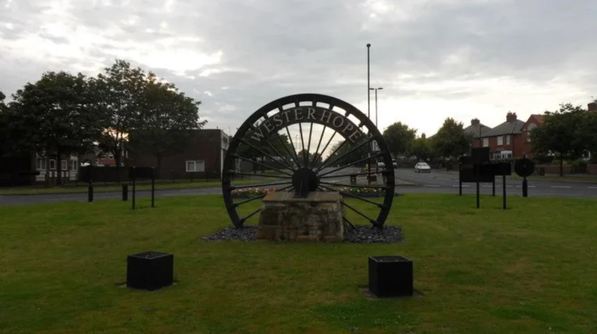
Chapel House and Westerhope are neighbouring NE5 areas in western Newcastle upon Tyne, but they developed from different historical foundations. Chapel House is principally a planned post-war suburban estate, while Westerhope developed from an older settlement shaped by agriculture, coal mining, industry and later suburban expansion.
- How did Chapel House and Westerhope develop?
- What was Westerhope like before it became a modern suburb?
- Why is Chapel House historically different from Westerhope?
- What role did coal mining play in Westerhope’s history?
- How did Newcastle’s post-war expansion change Chapel House and Westerhope?
- How did local government change the identity of Westerhope and Chapel House?
- What architectural character does Chapel House have?
- What historic features remain around Westerhope?
- Which area has the stronger connection to Newcastle’s industrial history?
- How do transport connections differ between Chapel House and Westerhope?
- Which area provides more historical interest for visitors and researchers?
- How should families compare Chapel House and Westerhope today?
- How do Chapel House and Westerhope represent the wider history of Newcastle?
- What should you consider when choosing between Chapel House and Westerhope?
- Why does the history of Chapel House and Westerhope still matter?
That difference remains visible in their physical character. Chapel House contains predominantly planned residential streets dating from the 1960s and early 1970s, while Westerhope retains stronger connections with an earlier village landscape and Newcastle’s coal-mining past. The distinction matters when comparing the areas for housing, transport, schools, local identity, green space and historical interest.
The comparison also requires care because the names describe overlapping parts of a wider western Newcastle landscape. Chapel House sits beside Chapel Park, Westerhope and West Denton, while Westerhope extends across a larger historic settlement area containing older industrial and agricultural features.
How did Chapel House and Westerhope develop?
Chapel House developed mainly as a planned 1960s suburban estate, while Westerhope developed earlier through farming, working-class settlement and coal mining before becoming a larger suburban district after the Second World War. Their contrasting origins explain much of their present-day physical character.
The historical difference begins before either area became a modern residential suburb. Newcastle upon Tyne expanded westward over a landscape containing agricultural holdings, historic routes, mining infrastructure and settlements. Newcastle City Council’s character assessment identifies ancient routes associated with Hadrian’s Wall and roads towards Stamfordham and Jedburgh as important influences on the western landscape.
Westerhope had an established settlement before the rapid twentieth-century expansion of Newcastle. Its development accelerated during the Victorian period when workable coal reserves were exploited. Coal mining transformed the local economy and created employment, housing demand and industrial infrastructure.
Chapel House followed a different trajectory. The modern estate belongs principally to the post-war period when Newcastle needed substantial quantities of new housing. The estate was developed during the 1960s and early 1970s, with John T. Bell associated with its design and construction.
Newcastle City Council’s character assessment records that the western part of the city contained mainly agricultural and mining buildings before rapid twentieth-century development. It specifically identifies former mining terraces at Chapel Park and the wagonway connections serving coal-mining locations around Blakelaw and Slatyford.
The result is a useful historical distinction. Westerhope represents an older settlement that was transformed by industrialisation and later suburbanisation. Chapel House represents the later planned residential expansion that absorbed the surrounding countryside and former industrial landscape.
What was Westerhope like before it became a modern suburb?
Westerhope began as a western settlement associated with working families, agriculture and domestic food production before Victorian coal mining transformed its economy. Its later suburban growth followed the decline of mining and Newcastle’s twentieth-century expansion beyond older urban districts.
Westerhope’s name and development are closely connected with its position west of Newcastle. Local historical records describe its early purpose as providing housing for working families with enough land for vegetable cultivation. This reflects a period when residential land, food production and employment were closely connected.
Agriculture remained important before industrial expansion. Newcastle City Council’s wider western character assessment identifies farms, agricultural buildings and historic estates as components of the landscape before large-scale twentieth-century housing development.
Coal changed that landscape. During the Victorian period, exploitable coal reserves encouraged industrial activity and population growth. The two major collieries associated with the wider Westerhope area were Coronation and North Walbottle.
North Walbottle Colliery became particularly important. Historical accounts record that it produced 21.5 million tons of coal before closing in 1968. Its closure was connected with concern about mining beneath the area of Newcastle International Airport, whose runway lay north of the colliery.
The mining landscape also included shafts, wagonways and associated infrastructure. Newcastle’s Historic Environment Record identifies Whindykes Quarry in Westerhope as an industrial site with evidence connected to eighteenth- and nineteenth-century mineral extraction.
The site formed part of the former Whorlton Estate and contained old shafts and wagonways. Whinstone quarrying also occurred there during the nineteenth century, demonstrating that the area’s industrial history was not limited to coal.
Westerhope therefore has a layered historical identity. Farming preceded industrialisation, coal mining transformed the settlement, and suburban development subsequently replaced many industrial land uses.
Why is Chapel House historically different from Westerhope?
Chapel House is historically distinctive because its present identity was created largely through planned post-war housing development. Westerhope contains older settlement, agricultural, mining and industrial layers, giving the two NE5 areas different historical landscapes despite their close geographical relationship.
The Chapel House estate belongs to the period when British cities expanded housing beyond older inner districts. Its construction created streets, houses, community facilities and services according to a planned suburban model rather than the gradual growth associated with an older village.
Sources describing the estate place its main construction between 1964 and the early 1970s. John T. Bell is identified with the development, and the estate consists principally of private residential properties.
The estate also developed community infrastructure alongside housing. A church opened on the Chapel House estate in 1964, demonstrating that religious and community facilities formed part of the area’s early suburban development. The original church was later replaced by a new building constructed in 1984–85 after problems with the earlier structure.
Education also changed with the estate. Chapel House Middle School served approximately 500 pupils before closing in 2005 as Newcastle’s outer-west education system moved from a three-tier structure to a two-tier system.
The area’s name also has a deeper historical connection. Newcastle’s Historic Environment Record separately identifies a historic Chapel House at Walbottle as a post-medieval domestic building associated with a former Wesleyan chapel.
That distinction is important. The modern Chapel House estate should not automatically be treated as identical to every historic building called Chapel House in the surrounding western Newcastle landscape.
What role did coal mining play in Westerhope’s history?
Coal mining was one of the main forces behind Westerhope’s Victorian expansion. Coronation and North Walbottle collieries created employment and industrial infrastructure, while the eventual closure of the pits helped accelerate the area’s transition from a mining landscape into a predominantly residential suburb.
The western districts of Newcastle were connected to the Great Northern Coalfield, one of the major coal-producing regions associated with the industrial development of Tyneside. Newcastle City Council describes coal as a fundamental driver of the region’s Industrial Revolution and identifies wagonways as early transport systems developed to move coal towards the Tyne.
Wagonways were particularly important because coal extraction depended on reliable transportation. Newcastle’s character assessment records wagonway connections from mining areas around Blakelaw and Slatyford towards the River Tyne, including routes crossing the western landscape.
Westerhope formed part of this wider industrial geography. Mining brought workers, housing and supporting businesses into areas that had previously been dominated by agriculture.
North Walbottle’s production figure of 21.5 million tons demonstrates the scale of extraction. Its closure in 1968 represented more than the end of an individual industrial operation. It formed part of the broader transition away from coal-based employment in western Newcastle.
The former mining landscape did not disappear completely. Some physical traces were absorbed into later development, while industrial memories survive through local heritage collections, memorials and historical records.
The West Newcastle Picture History Collection is particularly relevant for researchers. Newcastle City Council states that the collection contains more than 20,000 photographs and documents covering western Newcastle from the nineteenth century to the present, including Westerhope, North Walbottle, Throckley and other western communities.
How did Newcastle’s post-war expansion change Chapel House and Westerhope?
Post-war housing expansion transformed the western edge of Newcastle by replacing substantial areas of agricultural and industrial land with planned residential neighbourhoods. Chapel House emerged directly from this process, while Westerhope experienced suburban growth alongside its older village and mining landscape.
The change was part of a much larger urban process. Newcastle’s population and housing requirements created pressure for development beyond established inner districts. New residential estates offered larger homes, gardens and planned streets.
The western character assessment records that extensive twentieth-century development radically altered the landscape. Before this expansion, the area contained agricultural and mining buildings, while later estates introduced large-scale residential development.
Chapel House is one of the clearest examples of this transformation. Its houses were constructed during the 1960s and early 1970s, creating a coherent suburban environment close to Westerhope and other western estates.
Westerhope experienced simultaneous suburbanisation. The development of Chapel House, Chapel Park and St John’s formed part of the westward growth around the established settlement.
This process altered the relationship between old and new landscapes. Former agricultural fields became housing sites. Mining infrastructure lost its economic purpose. Roads gained greater importance as the car became increasingly central to suburban life.
The resulting NE5 landscape is therefore neither wholly historic nor wholly modern. It is a layered environment in which twentieth-century housing sits alongside evidence of agriculture, coal mining, transport and earlier settlement.
How did local government change the identity of Westerhope and Chapel House?
Westerhope and the surrounding western suburbs became part of the modern City of Newcastle during local government reorganisation in 1973–74. This administrative change coincided with major residential development and helped consolidate the western districts within Newcastle’s expanding urban area.
The Local Government Act 1972 reorganised local government in England and Wales, with the new metropolitan county structures taking effect in 1974. Westerhope became part of Newcastle’s expanded urban administration during this reorganisation. Historical local sources place the change in 1973–74.
The timing is significant because it coincided with substantial suburban expansion. Chapel House and Chapel Park were developing during the same broad period, creating a new residential geography around older western settlements.
Administrative boundaries did not erase local identities. Westerhope retained its village character and historic core, while Chapel House developed a distinct identity associated with its planned estate.
This explains why the areas can be geographically close but historically different. Local government created an integrated city administration, while housing development created separate neighbourhood identities.
What architectural character does Chapel House have?
Chapel House has the architectural character of a planned post-war residential estate, with housing designed and constructed across a concentrated period. Its streets, property types and community facilities reflect twentieth-century suburban planning rather than the incremental growth of an older village.
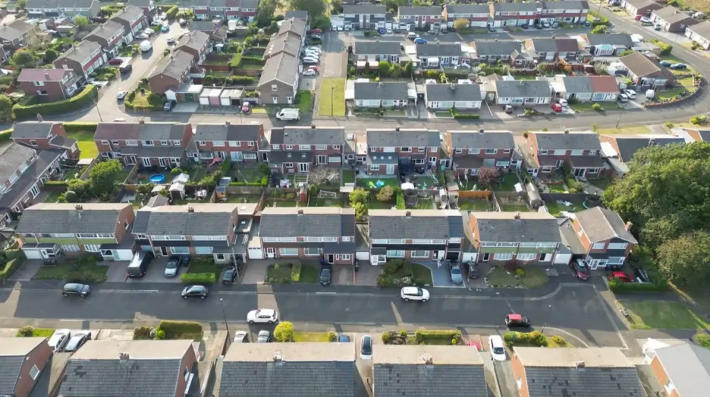
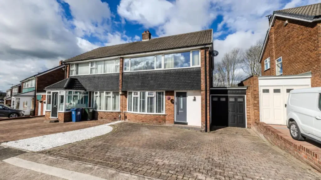
The estate’s development from the mid-1960s into the early 1970s produced a relatively consistent residential environment. Sources identify a mixture of housing forms, including semi-detached properties, terraces, linked homes, detached houses and bungalows.
This architecture reflects post-war housing priorities. Private gardens, garages, lower-density streets and family-sized accommodation became important features of suburban development.
Community facilities also formed part of the architectural environment. Churches, schools, shopping facilities and local services were positioned within or close to the residential estate.
The architectural significance of Chapel House therefore lies less in individual monumental buildings and more in the estate as an example of twentieth-century planned suburban growth.
For architectural historians, this makes Chapel House useful for studying the transition between older urban forms and the suburban planning practices of post-war Britain.
What historic features remain around Westerhope?
Westerhope retains evidence of its agricultural, mining and industrial past through historic routes, former extraction sites, village structures and surviving documentary records. These features provide physical and archival evidence of the settlement’s transformation before and during suburban expansion.
Whindykes Quarry is one documented example. Newcastle’s Historic Environment Record identifies the site as a Victorian industrial landscape associated with mineral extraction, coal workings, wagonways and whinstone quarrying.
The wider Whorlton landscape also demonstrates the importance of estates and farms before suburbanisation. Newcastle’s character assessment identifies Whorlton among the earlier buildings and landscapes that survived the transformation of the western city.
Cobblers Corner is another important reference point. Local historical material identifies it as the historic core of Westerhope and records continuing light industrial activity around the area.
The former mining landscape also survives through interpretation and historical memory. Researching Westerhope therefore involves more than looking for preserved buildings. Maps, photographs, archaeological records and industrial remains are equally important.
Newcastle City Council’s Historic Environment Record contains more than 17,000 sites across the city, including monuments, earthworks, cropmarks, historic parks and gardens, industrial sites and twentieth-century defence sites.
Which area has the stronger connection to Newcastle’s industrial history?
Westerhope has the more direct documented connection to coal mining and industrial extraction. Chapel House is more strongly associated with the later suburban transformation that followed the decline of mining and the expansion of Newcastle’s housing beyond established urban districts.
Westerhope’s industrial connection is supported by evidence of coal extraction, collieries, wagonways and quarrying. North Walbottle’s 21.5 million tons of recorded coal production provide a measurable indication of the area’s industrial scale.
Chapel House belongs to a later phase of the same broad historical transformation. Its development placed modern housing within a landscape previously shaped by farming, mining and transport routes.
This makes the two areas complementary for historical study. Westerhope helps explain the industrial economy that shaped western Newcastle. Chapel House helps explain the post-industrial suburban landscape that followed.
For genealogy, the distinction is also useful. Families associated with mining and industrial employment are more likely to appear in records connected with Westerhope, North Walbottle and surrounding mining communities. Families who moved into new private estates during the 1960s and 1970s belong to a later phase of Newcastle’s suburban population movement.
How do transport connections differ between Chapel House and Westerhope?
Both areas benefit from western Newcastle’s major road network, particularly connections around the A1 and A69. Westerhope’s elevated and hilly setting has limited Metro access, while Chapel House is closely associated with the road-based suburban transport network.
The A1 Western Bypass and A69 are central to the transport geography of western Newcastle. Westerhope sits near their junction and therefore has strong road connections towards Newcastle, the wider North East and the airport.
Westerhope does not have a Tyne and Wear Metro station within the settlement. Local historical sources attribute this partly to the area’s hilly terrain and state that bus services provide the principal public transport connection with Newcastle.
Chapel House also depends heavily on road and bus connections. Its position roughly five miles from Newcastle city centre places it within the city’s established outer-west suburban network.
The practical difference is therefore one of local transport geography rather than a complete separation. Residents of both areas use the wider western road system, while public transport choices depend on individual streets, bus routes and connections to nearby Metro stations.
For anyone comparing the areas, exact journey times should be checked from the specific property rather than assumed from the neighbourhood name.
Which area provides more historical interest for visitors and researchers?
Westerhope provides more visible evidence of older settlement and industrial history, while Chapel House provides a useful case study of post-war suburban planning. Researchers interested in Newcastle’s layered landscape can study both areas as different stages of western urban development.
Westerhope’s historical value comes from its relationship with agriculture, coal mining, quarrying and industrial transport. Its story extends across several centuries and connects directly with the wider history of the Great Northern Coalfield.
Chapel House is valuable for a different reason. Its planned streets and community facilities demonstrate how Newcastle responded to twentieth-century housing demand.
For historical researchers, these different layers create a useful chronological sequence. Agriculture and estates preceded industrialisation. Coal mining transformed employment and settlement. Industrial decline then created conditions for large-scale suburban redevelopment.
The wider Newcastle heritage system supports this type of research. The city’s Historic Environment Record includes archaeological reports, historic maps, photographs and building-recording information.
The West Newcastle Picture History Collection provides another research resource, with more than 20,000 photographs and documents covering western Newcastle and including Westerhope and North Walbottle.
To experience this historic landscape in person today, consult our comprehensive [Insert Anchor Text for Things to Do Article Here] for itineraries and visiting parameters.
How should families compare Chapel House and Westerhope today?
Families comparing Chapel House and Westerhope should examine individual properties, schools, transport routes, local services, green space and street-level conditions rather than treating NE5 as one uniform residential market. The two areas have different historical layouts and neighbourhood characteristics.
Chapel House’s planned development created a relatively structured residential environment with local facilities positioned around established housing. Newcastle City Council currently lists services such as Allerdale House within Chapel House, while local property information identifies shops, medical services and community facilities around the estate.
Westerhope contains a broader mixture of historic village elements, residential streets, commercial premises and former industrial areas. Its relationship with the A1 and A69 gives the area an important road connection.
School decisions require separate research because catchment boundaries, admissions arrangements and school performance change over time. A property’s postcode should therefore be checked against the current admission information rather than relying on general descriptions of the neighbourhood.
The same principle applies to property prices. Historic development patterns influence housing stock, but individual streets contain different property types, sizes, tenure arrangements and renovation histories.
The most reliable comparison is therefore property-specific. Historical character provides context, while current official information should establish present-day services and regulations.
How do Chapel House and Westerhope represent the wider history of Newcastle?
Chapel House and Westerhope together demonstrate Newcastle’s movement from agricultural and industrial landscapes towards planned suburban communities. Their contrasting histories show how mining decline, housing demand, transport infrastructure and administrative expansion reshaped the western edge of the city.
Newcastle’s broader history contains repeated cycles of expansion. The medieval city developed around defensive walls and the River Tyne. Industrialisation then expanded the city’s economic influence through coal, engineering, railways and manufacturing.
The western districts demonstrate a later phase of this process. Agricultural land and mining infrastructure were progressively incorporated into an expanding metropolitan landscape.
Westerhope represents the industrial stage particularly clearly. Coal extraction produced employment, transport requirements and settlement growth. When mining declined, the landscape entered a new economic phase.
Chapel House represents the suburban stage. Planned housing provided accommodation for a growing urban population and created neighbourhoods designed around twentieth-century expectations of private residential life.
The relationship between the two areas is therefore historically significant. They are not simply neighbouring housing districts. Together they record a transition from rural landholding and coal extraction to modern suburban Newcastle.
What should you consider when choosing between Chapel House and Westerhope?
The choice between Chapel House and Westerhope depends on the type of neighbourhood, housing environment, transport pattern and historical setting that best matches individual requirements. Chapel House reflects planned post-war suburbia, while Westerhope retains stronger links with older village and industrial history.
Chapel House provides a clear example of Newcastle’s 1960s and early-1970s suburban expansion. Its identity is closely tied to planned residential development, family housing and community infrastructure.
Westerhope provides a longer historical sequence. Its story incorporates agriculture, Victorian coal mining, industrial transport, quarrying, twentieth-century suburbanisation and integration into Newcastle’s modern administrative structure.
For history enthusiasts and heritage researchers, Westerhope offers more direct evidence of Newcastle’s industrial past. For students of twentieth-century planning and suburban architecture, Chapel House provides a concentrated example of post-war estate development.
For families and prospective residents, historical character should be considered alongside current information about schools, property condition, transport, amenities and local services.
The two areas should therefore be understood as complementary parts of NE5 rather than interchangeable neighbourhoods. Their proximity makes comparison straightforward, but their histories explain why their streets and built environments developed differently.
Why does the history of Chapel House and Westerhope still matter?
The history of Chapel House and Westerhope remains relevant because present-day streets preserve evidence of Newcastle’s transition from agriculture and coal mining to post-war suburban housing. Understanding that sequence explains local architecture, transport patterns, community identity and surviving heritage records.
Westerhope’s industrial history explains why the western landscape contains former extraction sites, wagonway routes and settlement patterns associated with mining. Chapel House’s history explains the later appearance of planned streets and residential estates.
The historical record also demonstrates that suburban areas are not historically empty spaces. Newcastle City Council’s archaeological and heritage records show that modern neighbourhoods frequently overlap with earlier landscapes and routes.
This is particularly important for preservation. Heritage does not depend only on famous listed buildings. Archaeological sites, historic maps, industrial remains, photographs and ordinary residential landscapes can all document how communities developed.
Newcastle City Council’s heritage programme includes conservation advice, archaeological services, heritage interpretation and the Historic Environment Record.
For future researchers, Chapel House and Westerhope provide a clear example of urban transformation. Westerhope records the social and economic geography of an industrial settlement. Chapel House records the planned suburban response to twentieth-century housing demand.
Their histories ultimately form one connected western Newcastle story: agricultural land became an industrial landscape, industrial activity declined, and expanding Newcastle incorporated the area into a modern suburban city.