

Byker is a historic district in the east of Newcastle upon Tyne, shaped by industrial employment, Victorian housing, community life and post-war redevelopment. Its history connects riverside industries with the internationally recognised Byker Wall housing estate and continuing neighbourhood regeneration.
- How did Byker develop before the industrial revolution?
- How did shipbuilding and heavy industry transform Byker?
- Why were Victorian terraces important to Byker’s working-class community?
- How did everyday life shape historic Byker?
- Why was Byker selected for major redevelopment in the 1960s?
- Who was Ralph Erskine, and what was his role in Byker’s transformation?
- What is the Byker Wall, and why is it architecturally important?
- How did resident participation influence Byker’s redevelopment?
- How has Byker changed from the 1980s to the present day?
- How is Byker’s industrial and architectural heritage preserved?
- What can visitors learn from Byker’s history today?
- Why does Byker’s history matter for Newcastle’s future?
Byker lies in the East End of Newcastle upon Tyne, Tyne and Wear, in north-east England. Its development reflects the wider transformation of Newcastle from an industrial centre into a modern city with a strong architectural and cultural identity.
The area expanded significantly during the nineteenth century as coal mining, shipbuilding, engineering and related industries created employment across the River Tyne region. Workers needed affordable accommodation close to factories, workshops, riverside yards and transport connections. Byker developed as a densely populated residential district serving these industries.
The area’s historic identity includes both its industrial foundations and its distinctive housing. Victorian streets accommodated working families, while later redevelopment replaced much of the old housing with an innovative residential environment designed by architect Ralph Erskine.
Newcastle’s Historic Environment Record documents the area’s industrial sites, residential buildings, transport infrastructure and archaeological evidence. These records establish Byker as an important part of the city’s built and social heritage.
Understanding Byker requires examining its industrial growth, everyday working-class life, changing housing conditions and the decisions that reshaped the neighbourhood during the twentieth century.
How did Byker develop before the industrial revolution?
Before large-scale industrialisation, Byker formed part of the agricultural and rural landscape east of Newcastle. Landownership, farming and settlement patterns shaped its early development before coal extraction, manufacturing and riverside trade transformed the district during the eighteenth and nineteenth centuries.
Byker’s early history predates the dense terraces associated with Victorian Newcastle. Historical and archaeological records identify evidence of earlier settlement and land use, including a manor house that has since disappeared.
Agriculture remained important before industrial employment expanded across the North East. Land was used for farming and other rural activities, while roads connected surrounding settlements with Newcastle’s growing urban centre.
The River Tyne became increasingly important as a commercial route. Its navigable waters supported the movement of raw materials and manufactured goods, encouraging industries to establish themselves near riverside transport and trading facilities.
Byker’s position east of central Newcastle connected it with this developing economic network. The district gradually changed from a landscape of scattered settlement and agricultural land into an area influenced by mines, workshops, transport routes and expanding urban housing.
The surviving historical record provides evidence of this transition. Newcastle’s Historic Environment Record documents industrial remains and archaeological sites that help researchers reconstruct the area’s changing character.
How did shipbuilding and heavy industry transform Byker?
Shipbuilding, coal mining, brickmaking, pottery and heavy engineering helped transform Byker into an industrial working-class neighbourhood. These industries generated employment and demand for housing, connecting the district’s growth with the wider industrial economy of Newcastle and the River Tyne during the eighteenth and nineteenth centuries.
Industrialisation changed the physical and economic landscape around Byker. The lower Ouseburn area, close to Byker and the River Tyne, developed a concentration of industrial enterprises that supplied local and regional markets.
Coal mining became an important activity in the Byker area towards the end of the eighteenth century. Brickmaking and pottery production also expanded during the nineteenth century. The Maling pottery factory continued operating into the mid-twentieth century, demonstrating the longevity of manufacturing in the district.
Other documented industries included glassmaking, chemical production, lead works, bottle manufacturing, roperies and iron foundries. Roperies produced the long ropes required by maritime and industrial operations, while foundries manufactured metal components for engineering and transport.
Shipbuilding and associated riverside activities connected Byker to the maritime economy of the Tyne. Nearby yards and workshops relied on skilled workers, suppliers and transport networks. The demand for labour supported the expansion of surrounding residential streets.
Industrial development also produced lasting physical evidence. Quayside walls, warehouses and former industrial sites preserve traces of the area’s commercial past. Some former riverside buildings have subsequently been converted to residential or other uses.
Byker’s industrial heritage therefore extends beyond shipbuilding alone. Its history includes the supporting industries, workers, housing and transport systems that sustained the wider Tyne industrial economy.
Why were Victorian terraces important to Byker’s working-class community?
Victorian terraced houses provided accommodation for the workers who sustained Byker’s industries. Built extensively during the late nineteenth century, these compact homes formed a dense residential neighbourhood where families lived near employment, shops, schools, public houses and community institutions.
Byker’s substantial Victorian expansion took place during the 1880s and continued into subsequent decades. Small, closely spaced houses accommodated the growing population of industrial Newcastle. Many buildings were designed to make efficient use of limited urban land.
The terraced layout created streets where neighbours lived close together. Local shops, schools, churches and public houses provided services within the residential area. These facilities helped establish everyday routines and strengthened relationships between households.
Many homes were modest in size and built to economical standards. As the housing stock aged, conditions deteriorated. Some properties lacked bathrooms, and a significant number required major repairs or improvements to meet modern standards.
However, poor housing conditions did not mean residents lacked attachment to their neighbourhood. Byker’s location near riverside employment, established social networks and familiar local facilities gave people strong reasons to remain.
The contrast between inadequate housing and valued community relationships later became central to the area’s redevelopment. Newcastle’s planners faced the challenge of improving living conditions without unnecessarily destroying the relationships that made Byker a functioning neighbourhood.
How did everyday life shape historic Byker?
Everyday life in historic Byker centred on industrial work, family households, local shopping and neighbourhood institutions. Residents shared streets and services within a compact urban environment, creating social connections that became important during redevelopment and influenced later approaches to community-focused housing design.
The neighbourhood’s physical layout influenced daily routines. Workers travelled to nearby industrial workplaces, families used local shops, and children attended neighbourhood schools. Churches, public houses and recreational facilities offered additional spaces for social interaction.
Proximity mattered because many households depended on local employment and public transport. The distance between home, workplace and everyday services shaped how residents used their neighbourhood.
The community also developed a distinct visual and cultural identity. Streets, building fronts, local businesses and shared public spaces formed the setting for ordinary family life. These features later became important subjects of historical documentation.
Photographer Sirkka-Liisa Konttinen documented Byker’s residents and streets before and during redevelopment. Her photographs preserve evidence of the people and housing that disappeared as the estate changed. The images provide an important visual record of working-class life and the emotional significance of the neighbourhood.
This social history is essential to understanding Byker. The district’s redevelopment involved more than replacing ageing buildings. It changed a familiar residential environment, making the preservation of community relationships a central planning concern.
Why was Byker selected for major redevelopment in the 1960s?
Byker was selected for redevelopment because much of its Victorian housing had deteriorated and required substantial improvement. Motorway proposals, overcrowding and concerns about living standards shaped planning decisions, while residents’ attachment to the area created pressure for a solution that preserved community relationships.
By the middle of the twentieth century, many Victorian homes in Byker were no longer suitable for contemporary housing standards. Poor facilities and structural deterioration created a need for extensive improvement.
In 1959, a proposed motorway running parallel to and south of Shields Road influenced the area’s future. Newcastle’s Historic Environment Record states that compulsory purchase associated with the road proposal displaced approximately 3,000 people and disrupted connections between Byker and shops and facilities on Shields Road. The resulting disruption contributed to neglect and vandalism.
In 1966, Newcastle City Corporation advanced redevelopment plans for Byker. The objective was to replace inadequate housing while retaining the neighbourhood’s social character.
The decision reflected a wider challenge facing British cities after the Second World War. Local authorities needed to improve housing, infrastructure and public services while responding to changing expectations about domestic facilities and urban living.
Byker became a significant example of the tension between large-scale clearance and community preservation. Demolishing old buildings offered an opportunity to improve living conditions, but it also threatened established streets, local landmarks and social connections.
The redevelopment approach subsequently developed in Byker sought to address these competing priorities through new housing, landscaping and resident involvement.
Who was Ralph Erskine, and what was his role in Byker’s transformation?
Ralph Erskine was a Swedish-British architect appointed to lead Byker’s redevelopment in 1969–1970. He developed a housing scheme that combined distinctive architecture, varied residential layouts and community participation, aiming to improve homes while maintaining important social relationships within the established neighbourhood.
Ralph Erskine became internationally associated with housing design that responded to residents’ practical needs and the character of individual places. His approach to Byker differed from redevelopment models based entirely on uniform high-rise blocks.
Newcastle appointed Erskine to the Byker project in February 1970, according to the city’s Historic Environment Record. His team worked on a comprehensive plan for the district, including housing, landscaping and the relationship between buildings and public spaces.
Erskine established a project office within Byker. Residents had a place to discuss their concerns and communicate their preferences to the design team. This arrangement gave the architect direct contact with people who understood the neighbourhood’s daily needs.
The resulting design combined a long outer residential structure with lower-rise houses and flats across the estate. The approach provided a recognisable architectural identity while responding to the area’s topography and the need for protected residential spaces.
Erskine’s work helped make Byker an influential example of community-oriented architecture. Its significance rests not only on the appearance of the buildings but also on the attempt to connect housing design with residents’ social needs.
What is the Byker Wall, and why is it architecturally important?
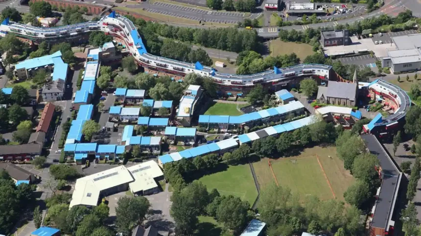
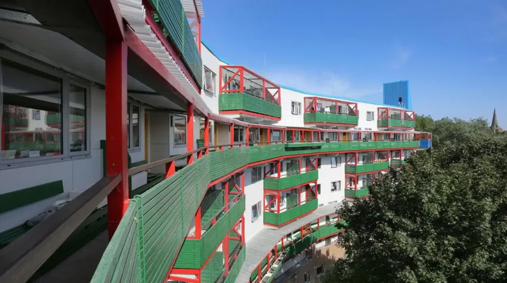
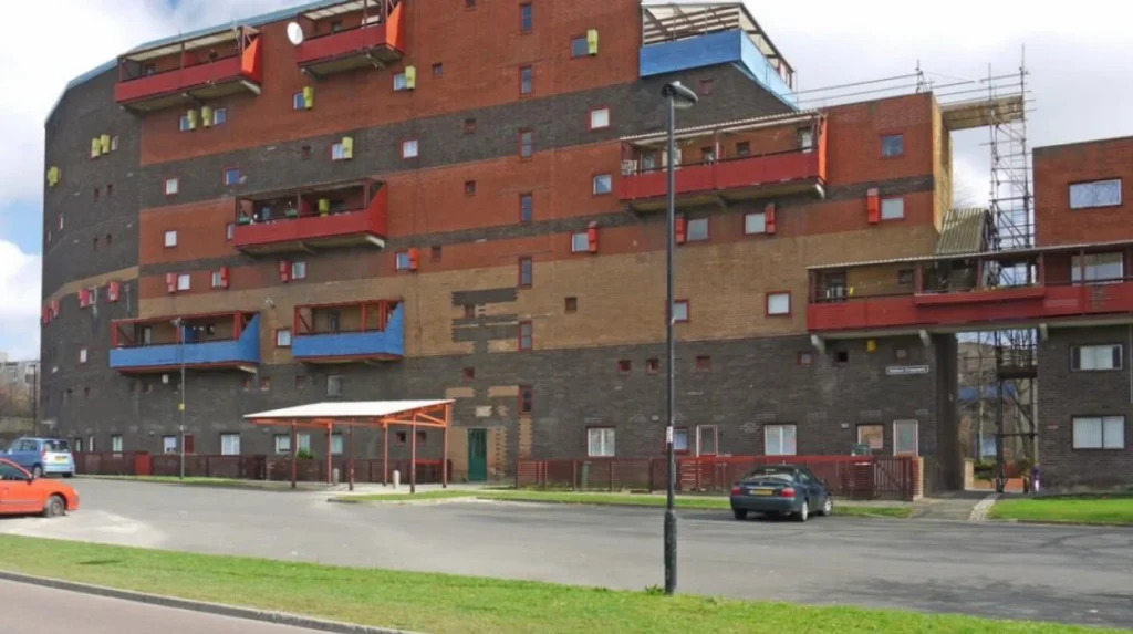
The Byker Wall is the distinctive curved residential structure forming a major part of Byker’s redeveloped housing estate. Designed under Ralph Erskine, it combines homes with an outer barrier that protects inner residential areas from wind and traffic pollution while defining the estate’s recognisable architectural character.
The Byker Wall emerged from a redevelopment programme undertaken from the late 1960s into the early 1980s. Historic England records the wider development as covering approximately 200 acres and housing around 9,500 people. The Wall itself varies from three to twelve storeys in height.
Its scale distinguishes it from the surrounding low-rise housing. The structure follows a long, curved line around parts of the estate, providing a physical boundary between external traffic and more sheltered residential areas.
The architectural approach combines several practical functions.
- Environmental protection: The outer structure helps shield inner housing from wind and traffic pollution.
- Residential variety: The wider estate includes low-rise terraces, individual houses and flats.
- Neighbourhood identity: The Wall creates a recognisable architectural landmark associated with Newcastle’s housing history.
The development also retained selected older buildings, including pubs, churches and swimming baths, integrating parts of the existing neighbourhood into the new layout.
The Byker Wall is important because it demonstrates how a large housing structure can serve as both a residential building and an environmental barrier. Its design remains central to discussions about post-war social housing, urban planning and the relationship between architecture and everyday life.
How did resident participation influence Byker’s redevelopment?
Resident participation helped distinguish Byker’s redevelopment from conventional clearance schemes. Ralph Erskine’s team consulted local people, operated from an office within the neighbourhood and used a phased building programme designed to maintain community connections while new homes and public spaces were developed.
Community involvement was a central feature of the project’s planning philosophy. Rather than treating existing residents solely as people to be relocated, the design process sought to incorporate their knowledge of local conditions and daily routines.
The project office gave residents opportunities to raise concerns, discuss design proposals and communicate their housing needs. This approach recognised that successful housing depends on more than the physical quality of buildings.
A rolling redevelopment programme also helped maintain continuity. Instead of clearing the entire neighbourhood before construction, the project progressed in stages. This arrangement supported the rehousing process and reduced the need to sever all existing local connections at once.
Historic records indicate that retaining social ties was an explicit objective of the redevelopment. Documentation of the estate also records that rehousing a substantial proportion of original residents on the original site formed part of the project’s achievement.
Participation did not eliminate every difficulty associated with demolition, relocation or major construction. Nevertheless, Byker became an important case study in community architecture, which places residents’ needs and involvement within the design and management of housing.
Its experience continues to inform debates about regeneration, especially in established neighbourhoods where housing improvements must be balanced against social continuity.
How has Byker changed from the 1980s to the present day?
Since the redevelopment period, Byker has remained a distinctive residential district within Newcastle. Its modern identity combines the Byker Wall, surviving industrial heritage, local shopping streets and community facilities, alongside continuing challenges involving housing maintenance, neighbourhood services and the preservation of architectural character.
The redevelopment changed Byker’s physical appearance, replacing much of its Victorian terraced housing with a planned residential environment. However, the area retained its role as a neighbourhood for local households rather than becoming solely a commercial or architectural destination.
The Byker Wall and its surrounding housing continue to represent an important phase in Britain’s social housing history. The estate’s design attracts attention from architects, historians, students and visitors interested in twentieth-century urban planning.
At the same time, Byker’s identity extends beyond its best-known building. Shields Road remains an important local shopping corridor, while nearby Ouseburn connects the district with Newcastle’s industrial past and its changing cultural landscape.
The Ralph Erskine Foundation describes Byker as a development whose original ambitions included maintaining community cohesion alongside improvements to housing. Its assessment also highlights the continuing importance of social investment and neighbourhood care in sustaining that ambition.
Modern Byker therefore represents an ongoing relationship between historic buildings, public services and residents’ everyday needs. Its future depends on maintaining homes, supporting local facilities and preserving the features that distinguish the area.
How is Byker’s industrial and architectural heritage preserved?
Byker’s heritage is documented through historic environment records, architectural assessments, surviving buildings and photographic collections. Newcastle’s Historic Environment Record identifies industrial remains and significant housing, while the Byker Wall demonstrates the architectural importance of twentieth-century social housing and community-focused redevelopment.
Heritage preservation involves more than retaining visually distinctive buildings. It also requires documenting historic land uses, industrial activity, neighbourhood development and the experiences of residents.
Newcastle’s Historic Environment Record provides information about archaeological sites, industrial remains and historic buildings across the city. Its Byker entries include former industrial sites and individual sections of the redeveloped housing estate.
- Historic Environment Record: Documents industrial archaeology, surviving buildings and redevelopment.
- Historic England: Provides information about the Byker housing development and its architectural significance.
- Photographic archives: Preserve visual evidence of Victorian streets, former residents and changes to the neighbourhood.
- Architectural research: Examines Ralph Erskine’s design methods and the relationship between housing and community life.
Preservation also involves maintaining the estate’s architectural details and residential quality. Alterations to buildings, materials and public spaces require careful consideration where historic character is significant.
For Byker, conservation is closely connected with practical housing management. Residents need safe, comfortable homes, while the estate’s distinctive design requires appropriate maintenance and sensitive improvements.
This balance helps ensure that Byker remains a functioning neighbourhood as well as an important part of Newcastle’s architectural heritage.
What can visitors learn from Byker’s history today?
Visitors exploring Byker can understand Newcastle’s industrial development, working-class housing and post-war architectural innovation within one neighbourhood. The Byker Wall, Shields Road and nearby Ouseburn provide different perspectives on the district’s industrial roots, residential transformation and continuing place in the city’s cultural identity.
A visit to Byker offers several ways to explore the district’s past.
Exploring the Byker Wall
The Byker Wall is the most recognisable starting point. Visitors can observe the building’s scale, curved form, changing heights and relationship with the surrounding residential streets.
Walking along Shields Road
Shields Road helps illustrate the importance of local shopping streets in neighbourhood life. It also provides context for the area’s redevelopment history, including the disruption associated with motorway proposals during the mid-twentieth century.
Discovering the Ouseburn industrial landscape
The nearby Ouseburn Valley contains evidence of the industrial activity that shaped this part of Newcastle. Former warehouses and other industrial buildings help explain the relationship between manufacturing, riverside trade and residential growth.
Visitors should remember that Byker is a residential neighbourhood. Exploring public streets respectfully, avoiding private property and minimising disruption to residents helps protect the community that gives the area its continuing identity.
Why does Byker’s history matter for Newcastle’s future?
Byker’s history matters because it demonstrates the connections between industrial employment, housing quality, architectural design and community stability. Its transformation shows that successful urban regeneration requires long-term attention to residents, public spaces, building maintenance and the preservation of local heritage.
First, housing improvements need to respond to residents’ actual needs. Replacing poor-quality homes is important, but relocation and demolition also affect social networks, familiar services and neighbourhood identity.
Second, architectural design influences everyday living conditions. The Byker Wall illustrates how building form, residential layouts and environmental protection can work together within a large housing development.
Third, community participation helps planners understand how people use their neighbourhood. Byker’s consultation process established an important example of involving residents in decisions about their homes and surroundings.
Finally, historic preservation requires continuing investment. Architectural significance alone does not guarantee that housing remains in good condition or that residents receive the services they need.
These lessons remain relevant to Newcastle’s wider regeneration efforts. The city’s industrial heritage and modern urban development are closely connected, and Byker offers a particularly clear example of how these forces shape a neighbourhood over time.
Byker’s history traces a transformation from an area shaped by agriculture and early settlement into a densely populated industrial neighbourhood, followed by major redevelopment in the second half of the twentieth century.
Shipbuilding, coal mining, pottery and engineering supported the district’s growth. Victorian terraces provided homes for workers and their families, creating a close-knit community whose social connections became a central consideration during redevelopment.
The appointment of Ralph Erskine introduced a different approach to housing design. The Byker Wall and surrounding residential buildings combined architectural innovation with an explicit aim to preserve community relationships.
Today, Byker remains an important part of Newcastle’s identity. Its industrial heritage, distinctive housing and continuing residential life provide valuable evidence of how cities change while retaining connections to their past.
Understanding Byker means looking beyond the Wall itself. The area’s full story includes the workers who built Newcastle’s industrial economy, the families who lived in its terraces, the residents who experienced redevelopment and the community that continues to shape the neighbourhood.