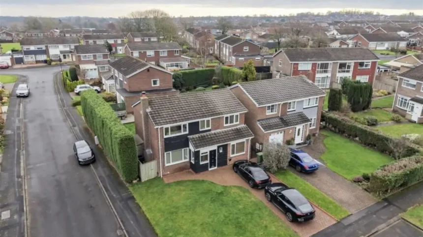
Chapel Park is a planned western Newcastle suburb shaped by post-war housing, earlier agriculture and coal mining. Today, its schools, shops, community facilities, green spaces and transport connections serve an established residential population while retaining traces of the landscape that preceded the estate.
- How did Chapel Park develop into a residential suburb of Newcastle?
- What schools serve families living in Chapel Park?
- What is the historical importance of Chapel Park’s former schools?
- Which amenities support everyday life in Chapel Park?
- How do green spaces and open areas shape Chapel Park?
- How does Chapel Park connect with Newcastle’s wider history?
- What local heritage resources can residents and researchers use?
- How has Chapel Park changed since its original development?
- Why are Chapel Park’s schools and amenities important to its future history?
How did Chapel Park develop into a residential suburb of Newcastle?
Chapel Park developed during Newcastle’s twentieth-century suburban expansion, replacing agricultural and mining landscapes with planned housing, schools, roads and open spaces. Planning records and historic assessments connect the estate with wider development across Newcastle’s western edge during the 1960s and 1970s.
Chapel Park occupies the outer western part of Newcastle upon Tyne in Tyne and Wear. Its modern character is predominantly residential, but its physical setting reflects a much longer history.
Newcastle City Council’s character assessment identifies ancient routes, agriculture and coal mining as important influences on the western part of the city. It records mining activity around Blakelaw and Slatyford and notes former mining terraces at Chapel Park. Before rapid twentieth-century development, the wider area contained agricultural and mining buildings rather than the continuous suburban housing seen today.
The transition was part of a wider change in Newcastle. The city expanded beyond its historic core as twentieth-century housing programmes created larger residential districts. Chapel Park and neighbouring Chapel House became part of this outward growth.
Chapel Park Middle School later provided education within the estate. Government education records show that the school operated from Granville Drive and served pupils aged 9 to 13. It closed on 1 September 2005 when Newcastle changed its outer-west education structure.
The closure illustrates an important stage in the suburb’s social history. Buildings originally designed for one education system became part of a different urban and educational landscape.
The former school site also demonstrates continuing land-use change. Newcastle City Council’s planning data records the former Chapel Park Middle School site as brownfield land, including open space previously used as playing fields.
Chapel Park therefore represents more than a collection of houses. It is evidence of the transformation of Newcastle’s western edge from agricultural and industrial land into a planned suburban environment.
What schools serve families living in Chapel Park?
Families in Chapel Park are served by primary schools within and around the adjoining estates, including Knop Law Primary School and Milecastle Primary School, while secondary-age pupils have access to schools elsewhere in Newcastle’s outer-west education network. Admissions depend on current council arrangements and individual school policies.
Knop Law Primary School has a particularly direct connection with Chapel Park. The school’s published history states that it was built in 2010 within Chapel House Estate and serves a catchment including Chapel House and Chapel Park, alongside St Johns, the Boultons, Abbey Grange and Abbey Farm estates.
The school accommodates up to 420 pupils aged approximately 4 to 11 and operates as a two-form-entry co-educational primary school. Its facilities include 14 classrooms, an information and communication technology suite, a music suite, technology room and library.
Milecastle Primary School is another important educational institution for the area. It is located on Hillhead Parkway in Chapel House and is listed by Newcastle City Council among the city’s primary schools.
The geographical relationship between Chapel Park and Chapel House is significant. The two estates developed as adjoining suburban communities, so education provision has historically crossed estate boundaries.
Newcastle City Council’s school directory currently separates schools by age, phase, type and other characteristics. This is important because the city’s education system has changed considerably since Chapel Park was first developed.
The current system differs from the former middle-school structure. Chapel Park Middle School was a community middle school for ages 9 to 13, but government records confirm that it closed in 2005.
For families researching schools today, historical school names should therefore be distinguished from currently operating establishments. Older references to Chapel Park Middle School describe a former institution rather than a current school.
The council’s 2026 Reception information also lists schools with available Reception places, demonstrating that school availability changes during the academic year. The list includes nearby institutions such as Milecastle Primary School and other Newcastle primary schools.
School selection also involves more than distance. Parents need to examine current admission arrangements, catchment boundaries, age ranges, inspection information and school policies because these details change over time.
For historical research, the former schools remain useful evidence. Their locations demonstrate how educational infrastructure was originally integrated into post-war estate planning.
What is the historical importance of Chapel Park’s former schools?
Former schools in Chapel Park record the changing structure of post-war education and suburban planning. Chapel Park Middle School operated from Granville Drive before closing in 2005, while its former site later entered Newcastle’s planning and land-use records as a redevelopment opportunity.
The history of education in Chapel Park is closely connected to the history of the estate itself.
When the suburb was developed, schools were planned as part of a wider residential infrastructure. The objective was to provide education close to expanding housing rather than requiring every child to travel into the historic city centre.
Chapel Park Middle School was registered as a community school serving pupils from ages 9 to 13. Its recorded capacity was 302 pupils. Government records identify its address as Granville Drive, Chapel Park, NE5 1SH.
Its closure in 2005 resulted from the restructuring of Newcastle’s outer-west education system. The change forms part of a broader shift from middle-school arrangements towards the two-tier primary and secondary structure used today.
The former school site provides a physical example of how educational buildings can acquire new roles after institutional closure. Newcastle’s brownfield-land register identified part of the former Chapel Park Middle School site as 0.66 hectares and recorded potential for between 20 and 24 dwellings on that brownfield portion.
This does not mean the entire former school and playing-field area consisted of developable land. The council record specifically distinguishes the brownfield part from the larger former school site and notes open space previously used as playing fields.
For local historians, this distinction matters. It shows how modern planning records preserve information about earlier community infrastructure even after the original building has ceased to function as a school.
Which amenities support everyday life in Chapel Park?
Chapel Park benefits from a network of nearby shops, services, schools, libraries, community facilities, open spaces and transport routes. Many essential amenities are distributed across Chapel Park, Chapel House, Westerhope, West Denton and the wider outer-west Newcastle area.
The suburb’s amenities reflect its relationship with neighbouring communities. Chapel Park does not operate as an isolated settlement. Residents use facilities across the adjoining residential districts.
Local shopping provision developed alongside the estates. Commercial premises support everyday requirements such as groceries, food, personal services and other household needs. Larger shopping destinations are also accessible elsewhere in western Newcastle.
Community facilities provide another layer of local infrastructure. Newcastle City Council states that community centres across the city provide low-cost activities, including children’s activities and exercise sessions, with many facilities managed through local community associations.
Libraries are also important educational and cultural amenities. Newcastle currently operates 14 libraries. Services include public computers, printing, scanning, children’s activities, reading groups, history and heritage resources and information services.
Outer West Library and Community Hub provides a particularly relevant service for residents in western Newcastle. Its facilities include books for adults and children, public computers, Wi-Fi, printing, scanning, children’s story sessions and access to digital resources through BorrowBox.
These facilities have historical importance as well as practical value. Libraries and community hubs preserve local information, support education and provide spaces where residents interact with public services.
The distribution of amenities also reflects the design of twentieth-century suburbs. Schools, shops, open areas and community facilities were incorporated into residential districts rather than concentrating every service in Newcastle city centre.
That arrangement remains important today because Chapel Park’s identity is based partly on its relationship with surrounding suburbs.

How do green spaces and open areas shape Chapel Park?
Green spaces form an important part of Chapel Park’s suburban structure, providing recreational land, landscaped areas and remnants of earlier land uses. Former playing fields and surviving landscape features also help explain how the estate developed from rural and industrial surroundings.
Open space is an important part of the historical development of Chapel Park.
The former Chapel Park Middle School site included playing fields and open space. Newcastle’s brownfield register specifically records this relationship when describing the redevelopment potential of part of the former school site.
The wider western landscape also contains evidence of earlier industrial activity. Newcastle City Council’s character assessment identifies former mining terraces at Chapel Park and records the influence of historic transport routes associated with coal mining.
These landscape remnants provide evidence of continuity beneath the modern residential environment.
Before the housing estates appeared, the area contained agricultural buildings and mining infrastructure. Coal from western Newcastle’s mining districts was transported towards the Tyne through wagonway networks. The council’s character assessment identifies the North Walbottle and related routes as part of this historic transport landscape.
Modern open spaces therefore have two functions. They support contemporary recreation while also retaining traces of earlier land organisation.
For educators, this creates an accessible way to explain landscape change. A single residential neighbourhood can demonstrate agricultural land use, industrial extraction, transport infrastructure, post-war planning and contemporary urban management.
How does Chapel Park connect with Newcastle’s wider history?
Chapel Park belongs to a much older Newcastle landscape shaped by Roman frontier activity, medieval settlement, agriculture, coal mining, industrial transport and twentieth-century urban expansion. Its modern streets form one recent layer within this longer sequence of regional development.
Newcastle’s history extends back to Roman Britain. Newcastle City Council identifies Pons Aelius as the Roman settlement associated with the River Tyne crossing and describes Hadrian’s Wall as a major frontier structure.
The city’s medieval development followed the Roman period. Newcastle’s castle was founded in 1080 by Robert Curthose, son of William the Conqueror, on the strategic sandstone high ground above the Tyne. The settlement subsequently developed into an important regional centre.
Chapel Park lies outside this historic core, but the western landscape formed part of the territory through which Newcastle expanded.
Coal mining became particularly important to the region. The western Newcastle landscape contained mines, wagonways and agricultural settlements before suburban development transformed the area.
The Newcastle City Council character assessment specifically identifies ancient routes and mining infrastructure as major influences on the western zone. It records that mining locations around Blakelaw and Slatyford were connected to the Tyne by wagonways.
This historical context explains why modern suburbs do not follow a completely arbitrary layout. Older routes, field boundaries, industrial sites and settlements influenced later development.
The result is a layered landscape. Roman history belongs to the earliest documented phase. Agriculture shaped the pre-industrial landscape. Coal mining introduced industrial infrastructure. Post-war planning introduced large-scale housing. Contemporary redevelopment continues the process.
What local heritage resources can residents and researchers use?
Newcastle provides official heritage resources that help residents investigate historic buildings, archaeological sites, former industrial landscapes and local people. The council’s Historic Environment Record, heritage programmes and commemorative plaques provide starting points for research into Chapel Park and surrounding districts.
Newcastle City Council operates a Historic Environment Record known as the Historic Environment Record, or HER. The council describes its online Sitelines service as a way to investigate archaeological sites and monuments across the area.
This resource is particularly relevant to Chapel Park because much of the suburb’s history survives through landscape evidence rather than prominent historic buildings.
The council also operates a commemorative plaque programme. More than 100 plaques across Newcastle identify historic buildings, structures and connections with notable people.
Heritage Open Days provide another research and education opportunity. Newcastle and Tyne and Wear participate in the annual September programme, which includes buildings, tours, walks, talks and heritage activities.
For educators, these resources support place-based learning. Students can compare historic maps, archaeological records, planning documents and modern photographs to identify changes in land use.
For genealogical researchers, school records, electoral material, property documents and local directories can help establish how families interacted with the developing suburb.
Chapel Park’s relatively recent residential history also creates a valuable source base. Because much of the estate was developed during the twentieth century, planning records, school documentation and property histories provide detailed evidence of its transformation.
To connect the historical landscape with present-day exploration, consult our comprehensive for itineraries and visiting parameters.
How has Chapel Park changed since its original development?
Chapel Park has evolved from a newly planned suburban estate into an established residential community, while school closures, property alterations, redevelopment proposals and changing services have modified its original post-war structure without removing its wider historical context.
The earliest residential phase established the basic street network and housing pattern. Later decades brought extensions, renovations and changes to individual properties.
Schools also changed. The closure of Chapel Park Middle School in 2005 represented one of the clearest institutional changes. The former school’s land subsequently became part of planning discussions concerning brownfield development and open space.
The surrounding education network also changed. Knop Law Primary School was built in 2010 within Chapel House and became a major primary provider for children from Chapel House and Chapel Park.
Planning activity continues to shape the estate and surrounding districts. Newcastle’s planning monitoring documents include applications relating to Chapel Park, including housing, access, parking, open space, landscaping and infrastructure.
A 2024 planning application also concerned land at the former Parkway School site in Chapel Park. The application record identifies the location east of Eden Close and south of Grosvenor Way.
These records demonstrate that suburban development did not end when the original houses were completed. Established neighbourhoods continue to change through redevelopment, adaptation and infrastructure investment.
Why are Chapel Park’s schools and amenities important to its future history?
Chapel Park’s schools, community facilities and open spaces will remain important historical evidence because they document changing approaches to housing, education, recreation and suburban planning. Their evolution connects present-day residents with Newcastle’s wider record of urban expansion and landscape change.
The historical value of Chapel Park lies in the relationship between its physical environment and its institutions.
Its houses demonstrate post-war suburban design. Its former school records demonstrate changes in education. Its open spaces record both recreation and earlier land uses. Its surrounding roads preserve connections with older settlements and industrial routes.
The suburb also provides a useful case study for understanding Newcastle’s western expansion.
Newcastle City Council describes the city’s history as a long sequence of change and continuity, stretching from Roman settlement through medieval development and industrialisation to modern urban growth.
Chapel Park fits this broader pattern at a local scale.
Its history begins before the houses themselves. Agricultural land and mining activity shaped the landscape. Industrial transport routes connected the western coalfield with the Tyne. Twentieth-century housing replaced much of that landscape with planned residential development. Schools and community infrastructure were built to serve the new population. Later reforms altered those institutions.
This chronology gives Chapel Park relevance beyond its immediate residential function.
For local historians, the suburb provides evidence of twentieth-century urban planning. For educators, it offers a practical example of how land use changes over time. For genealogists, its property and institutional records provide evidence about families who moved into Newcastle’s expanding western suburbs.
The most useful approach is therefore to treat Chapel Park as a layered historical landscape rather than a purely modern housing estate.
Its schools and amenities are part of that historical record. Knop Law Primary School represents twenty-first-century educational provision. Milecastle Primary School forms part of the established local education network. Chapel Park Middle School represents the former middle-school system. Libraries and community facilities demonstrate the continuing role of public infrastructure.
The landscape surrounding these institutions adds another layer. Former mining terraces, historic routes and surviving open areas connect the suburb to periods before residential construction.
Chapel Park’s future historical importance will depend partly on how these elements are documented and managed. Newcastle City Council’s heritage services already support archaeological research, interpretation, conservation and public engagement.
For residents, the result is a neighbourhood where everyday amenities sit within a landscape shaped by centuries of change.
For researchers, Chapel Park offers a clear example of Newcastle’s movement from rural and industrial land towards planned suburban living.
That combination explains why schools and amenities are central to understanding Chapel Park. They are not separate from the suburb’s history. They are evidence of how the community was planned, how its population was served and how Newcastle’s western edge has continued to change.