



Scotswood Road is one of the historic routes that explains the industrial development of Newcastle upon Tyne. Located in the city’s western districts, the road connects the history of heavy engineering, Victorian working-class communities, shipbuilding, transport and urban regeneration. Its development followed the expansion of factories along the River Tyne, particularly the engineering works established by William George Armstrong at nearby Elswick in 1847.
- What is the historical significance of Scotswood Road in Newcastle?
- How did Scotswood Road develop before the industrial boom?
- Who was William Armstrong, and why did he shape Scotswood Road’s history?
- How did Elswick Works transform the industrial landscape around Scotswood Road?
- What products were manufactured at Armstrong’s Elswick and Scotswood works?
- How did industrial employment change the population of Newcastle’s West End?
- What was daily life like for workers living near Scotswood Road?
- How did shipbuilding and the River Tyne influence Scotswood Road?
- What happened to Armstrong’s works during the twentieth century?
- Which industrial heritage sites remain around Scotswood Road today?
- How has regeneration changed the area around Scotswood Road?
- Why does Scotswood Road matter to Newcastle’s wider history?
- How can readers research the history of Scotswood Road further?
During the nineteenth century, the industrial growth of Elswick and Scotswood transformed Newcastle’s West End. Engineering factories attracted workers from across Britain and Ireland, while housing, shops, public houses and transport infrastructure expanded to support the growing population. The Armstrong industrial complex became a major employer and an internationally recognised centre for hydraulic machinery, armaments and shipbuilding.
Today, Scotswood Road remains an important part of Newcastle’s urban geography. Modern business premises, transport corridors and riverside redevelopment occupy land once associated with large industrial works. Historic records held by Newcastle’s local heritage services document the former factories, surviving industrial structures and changing landscape.
Understanding Scotswood Road’s history therefore requires more than examining the road itself. Its story is closely connected to William Armstrong, Elswick Works, the River Tyne, industrial employment and the social development of Newcastle’s West End.
What is the historical significance of Scotswood Road in Newcastle?
Scotswood Road is a historic western Newcastle route associated with Victorian industrial expansion, Armstrong’s engineering works and the growth of working-class communities. Its development reflects the relationship between manufacturing, employment, housing and transport along the River Tyne.
Scotswood Road gained historical importance as industry expanded westwards from Newcastle’s central districts. The nearby settlements of Elswick and Scotswood became closely connected to the city’s growing engineering economy during the nineteenth century.
The road formed part of a wider industrial landscape in which factories, workshops, riverside facilities and residential streets developed alongside one another. Large employers needed reliable access for workers, materials and finished products. Roads and railway connections helped move goods between factories, Newcastle’s commercial centre and wider national markets.
Newcastle’s industrial heritage records identify Armstrong’s Elswick and Scotswood Works as a major regional engineering complex during the late nineteenth century. The works expanded along the north bank of the Tyne and incorporated manufacturing activities that extended well beyond the original production of hydraulic machinery.
The significance of Scotswood Road also lies in its connection to everyday working life. The industrial economy supported households, local businesses and new housing across the West End. Its history demonstrates how a transport route became associated with the economic and social transformation of an entire district.
How did Scotswood Road develop before the industrial boom?
Before large-scale Victorian manufacturing transformed the area, Newcastle’s western districts contained smaller settlements, agricultural land and riverside activity. Industrial expansion after the 1840s changed this landscape through factory construction, population growth and the spread of residential development.
Newcastle developed around the River Tyne as a centre for trade, transport and manufacturing. Its riverside location provided access to shipping, raw materials and markets, while connections to coal-producing districts strengthened its industrial importance.
West of the historic city centre, areas including Elswick and Scotswood initially had a more dispersed settlement pattern. Their subsequent development followed the growth of engineering and shipbuilding enterprises along the river.
The expansion of the railway network also strengthened Newcastle’s industrial connections. The railway reached Newcastle in 1839, helping improve regional transport links before Armstrong established his Elswick works. Railways supported the movement of people and goods and connected industrial districts with wider commercial networks.
The creation of new factories brought a fundamental change to the western landscape. Land increasingly accommodated workshops, storage facilities, industrial buildings and housing. Streets expanded as employers recruited more workers, and local businesses developed to serve the growing population.
The transformation did not happen in a single year. It followed decades of industrial investment, technological development and migration. Scotswood Road became part of this expanding urban environment, linking residential districts with employment centres and commercial activity.
Who was William Armstrong, and why did he shape Scotswood Road’s history?
William George Armstrong (1810–1900) was a Newcastle-born engineer, inventor and industrialist whose company transformed Elswick into a major manufacturing centre. His hydraulic machinery, artillery and shipbuilding enterprises helped drive employment and urban expansion across Newcastle’s western districts.
Armstrong originally trained and worked as a solicitor before pursuing engineering. His interest in hydraulic power led to the development of machinery that used pressurised water to perform heavy work.
In 1846, he patented a hydraulic crane design. The technology offered an effective method of lifting heavy loads in ports, warehouses and industrial facilities. In 1847, Armstrong established an engineering works at Elswick, west of Newcastle’s centre, to manufacture hydraulic machinery.
The enterprise initially concentrated on cranes and related equipment. Commercial demand encouraged expansion, and the company subsequently diversified into artillery and other forms of heavy engineering.
Armstrong’s industrial influence extended beyond Scotswood Road. His engineering achievements included the hydraulic mechanism associated with London’s Tower Bridge and the design of Newcastle’s Swing Bridge. His Northumberland estate, Cragside, also became internationally recognised for its use of hydroelectric power.
North East Museums identifies Armstrong as a major figure in Victorian engineering and records that his Elswick works employed approximately 25,000 people at its peak. This figure illustrates the scale of the industrial operation and its importance to Newcastle’s economy.
Armstrong’s legacy remains central to the history of Scotswood Road because his industrial enterprise helped shape the surrounding employment market, housing demand and urban geography.

How did Elswick Works transform the industrial landscape around Scotswood Road?
Elswick Works began in 1847 as a relatively small hydraulic machinery factory and developed into a large engineering, armaments and shipbuilding complex. Its expansion created thousands of jobs, attracted investment and reshaped the industrial landscape west of Newcastle city centre.
The early works occupied a modest riverside site. Armstrong’s hydraulic technology provided the foundation for further investment, allowing the business to expand into new manufacturing activities.
During the nineteenth century, the company developed artillery production alongside its original engineering operations. The establishment of the Elswick Ordnance Company in 1859 separated Armstrong’s armaments activities from his other interests during a period when he also held a government role connected with artillery development.
Shipbuilding became another important part of the industrial complex. In 1882, Armstrong’s business combined with the shipbuilding enterprise associated with Charles Mitchell to form Armstrong, Mitchell and Company. The following year, the newly combined company established a naval shipbuilding yard at Elswick.
A further merger with the engineering business associated with Joseph Whitworth followed in 1897. The resulting company, Sir W. G. Armstrong, Whitworth & Co., brought together major engineering and armaments interests.
The works extended for more than a mile along the Tyne by the beginning of the twentieth century. Production involved a range of industrial activities, including hydraulic machinery, heavy engineering, artillery and naval construction.
This expansion affected Scotswood Road through the growth of nearby employment, housing and commercial services. The road became part of the wider network serving one of the region’s most significant industrial concentrations.
What products were manufactured at Armstrong’s Elswick and Scotswood works?
Armstrong’s industrial operations produced hydraulic cranes, heavy machinery, artillery and naval equipment, while associated facilities supported shipbuilding and other engineering activities. These products connected Newcastle’s West End with national infrastructure projects, military contracts and international industrial markets.
Hydraulic cranes formed the foundation of Armstrong’s original business. These machines used hydraulic pressure to lift heavy loads and became valuable for dockside handling, railway operations and industrial work.
The company later expanded into artillery. Armstrong’s breech-loading gun designs became associated with developments in nineteenth-century military engineering. The production of guns and ammunition required specialised machinery, skilled labour and extensive manufacturing facilities.
Shipbuilding and naval engineering expanded the industrial operation further. The company’s facilities supported the construction and fitting-out of warships, combining engineering expertise with metalworking and armaments production.
The wider Armstrong enterprise also diversified into other engineering sectors over time. Following corporate mergers and later developments, its industrial activities became associated with additional forms of machinery and transport-related manufacturing.
These operations required different occupational skills. Engineers, metalworkers, machinists, foundry workers, fitters and other employees contributed to production. The concentration of these occupations made the Elswick and Scotswood area an important centre for industrial employment.
The works also demonstrated how manufacturing businesses could integrate several stages of production within one industrial district. Raw materials entered the manufacturing process, specialised components were produced and assembled, and finished equipment moved towards customers through road, rail and river connections.
For Scotswood Road, this industrial system meant that local development depended not only on the factories themselves but also on the transport, housing and commercial infrastructure needed to sustain them.
How did industrial employment change the population of Newcastle’s West End?
Armstrong’s expanding works attracted workers from Newcastle, surrounding districts and further afield. Employment growth encouraged rapid housing construction in Elswick and Scotswood, transforming formerly smaller settlements into densely populated urban communities connected to the industrial economy.
Industrial expansion created demand for large numbers of workers. People moved to Newcastle in search of employment, including migrants from Ireland, Scotland and rural parts of Britain. The resulting population increase placed pressure on housing, transport and local services.
Newcastle Heritage’s historical account of Scotswood and Elswick records a particularly rapid rise in the population of Elswick. The population increased from 3,539 in 1851 to 14,341 in 1861 and exceeded 51,000 by the end of the nineteenth century. These figures demonstrate the scale of urban change associated with industrial growth.
The increase in population supported the expansion of residential streets around the industrial sites. Terraced housing became a defining feature of many working-class neighbourhoods because it accommodated growing numbers of households within relatively compact urban areas.
The new communities also needed shops, public houses, schools, places of worship and other services. Local businesses benefited from the spending power of industrial workers and their families.
However, industrial employment did not remove the social challenges of rapid urbanisation. Crowded housing, pollution, workplace hazards and dependence on major employers affected many industrial communities. The quality of life experienced by residents varied according to wages, occupation, household circumstances and access to public services.
Scotswood Road therefore belongs to a broader history of industrial urbanisation. Its development reflects the close relationship between factory employment, migration, residential expansion and the formation of Newcastle’s West End communities.
What was daily life like for workers living near Scotswood Road?
Daily life in industrial Newcastle combined factory employment with family responsibilities and neighbourhood activity. Workers depended on local housing, shops, transport and community institutions, while industrial wages supported the businesses and services that developed around the Elswick and Scotswood works.
Industrial work structured the daily routines of many households. Factory employees travelled to manufacturing sites, completed specialised tasks and worked within production systems shaped by machinery, management and customer demand.
The industrial workforce included skilled and semi-skilled occupations. Machinists, engineers and fitters required technical knowledge, while labouring and supporting roles helped maintain production. The precise working conditions differed between departments and changed over time.
Housing developed near employment centres because walking to work reduced the cost and time associated with daily travel. Terraced streets also encouraged the development of neighbourhood shops and services.
Scotswood Road and the surrounding districts formed part of this everyday environment. Residents used local commercial premises, travelled through the area and relied on nearby services for household needs. Public houses, including establishments associated with the names Armstrong and Hydraulic Crane, reflected the district’s connection with the engineering works. Newcastle’s historic environment records the former Hydraulic Crane public house on Scotswood Road and its association with Armstrong’s early crane enterprise.
Industrial communities also developed through family and social networks. New arrivals relied on relatives, neighbours and established community institutions as they settled in the city.
The industrial economy brought employment opportunities, but dependence on large manufacturers also exposed households to economic uncertainty. Changes in production, industrial disputes and downturns affected workers whose livelihoods depended on particular factories.
These experiences explain why the history of Scotswood Road includes both industrial achievement and the social conditions of the people who sustained it.
How did shipbuilding and the River Tyne influence Scotswood Road?
The River Tyne provided the transport corridor and maritime setting for Newcastle’s industrial expansion. Shipbuilding and engineering operations at Elswick and nearby riverside sites relied on access to the river, while Scotswood Road connected surrounding neighbourhoods with factories and commercial activity.
The Tyne was central to Newcastle’s development as an industrial city. Its navigable waters supported shipping, trade and the movement of materials, while riverside land offered suitable locations for engineering works and shipyards.
Armstrong’s expansion into naval engineering strengthened the relationship between manufacturing and maritime activity. The Elswick complex combined the production of heavy equipment with facilities associated with warship construction and armament.
The wider Tyneside shipbuilding economy included other firms and yards, each contributing different capabilities. The location of engineering and shipbuilding enterprises close to one another supported the supply of machinery, metal components and specialist services.
Scotswood Road’s role was part of this larger system. Road transport linked workers and businesses with riverside industrial facilities, while railway connections supported the movement of goods beyond the immediate district.
The industrial landscape also required substantial infrastructure. Factories needed power, storage, workshops and transport access. The concentration of these facilities made the Tyne’s banks one of the defining industrial landscapes of Victorian Newcastle.
Industrial activity later declined as the structure of British manufacturing changed. Competition, corporate restructuring and shifts in demand affected traditional heavy engineering and shipbuilding. The river continued to shape the city, but its role increasingly included recreation, regeneration and urban development alongside maritime activity.
Understanding the relationship between the Tyne and Scotswood Road helps explain why the area became a major industrial district and why its later redevelopment focused on former riverside factory land.
What happened to Armstrong’s works during the twentieth century?
Armstrong’s industrial empire underwent corporate restructuring and long-term change during the twentieth century. The decline of traditional heavy engineering affected employment and land use, while the closure of Scotswood Works in 1979 marked a major break with the area’s manufacturing past.
The industrial enterprise continued after William Armstrong’s death in 1900. The company remained associated with engineering, armaments and shipbuilding, although the wider industrial environment became increasingly challenging.
Armstrong, Whitworth joined the Vickers group in a merger that created Vickers-Armstrongs in 1927. Newcastle’s historic environment record dates the takeover of the Armstrong works to 1928. These changes formed part of a broader period of consolidation within British heavy industry.
During the twentieth century, industrial production faced changing market conditions, technological developments and international competition. The demand for traditional products fluctuated, while companies reorganised their manufacturing operations.
The Scotswood Works eventually closed in 1979. Newcastle’s Historic Environment Record states that the site was subsequently cleared to make way for a new armaments factory, which opened in 1982. The earlier industrial complex was later replaced in part by the Newcastle Business Park development.
The closure represented more than the loss of a factory. Industrial employment had shaped local household incomes, commercial activity and the identity of surrounding neighbourhoods for generations.
The redevelopment of former industrial land created opportunities for new businesses and uses, but it also changed the physical environment. Large manufacturing complexes gave way to different forms of commercial development, leaving a more limited collection of visible industrial remains.
This transition is essential to understanding modern Scotswood Road. Its current surroundings reflect the gradual movement from heavy manufacturing towards a more varied urban economy.
Which industrial heritage sites remain around Scotswood Road today?
Industrial heritage around Scotswood Road survives through recorded archaeological remains, historic references and the wider riverside landscape. Newcastle’s heritage records identify remnants associated with the former Armstrong works, although much of the original industrial complex has disappeared or been redeveloped.
The scale of the former Elswick and Scotswood works makes complete preservation difficult. Manufacturing buildings occupied extensive riverside land, and many structures were altered, demolished or replaced as industrial activity changed.
Newcastle’s Historic Environment Record identifies a series of concrete arches on stone bases among the surviving structural remains associated with the former works. The record describes nine principal arches, accompanied by four smaller partially blocked arches, measuring approximately 30 feet in height and extending for around 70 yards.
The record also identifies other structures farther east, including truncated arches. It cautions that some surviving structures probably date from the early twentieth century rather than the original Victorian phase of the works. This distinction matters when interpreting the site’s architectural history.
Newcastle Heritage’s riverside material also documents the industrial significance of Scotswood and Elswick. The present riverside environment contains modern development, paths and heritage interpretation, although little of the original industrial complex remains visible.
The former Hydraulic Crane public house provides another example of how industrial history survives through records even when buildings no longer exist. The establishment was associated with the nearby engineering enterprise and was demolished in 1996.
Visitors interested in the area’s past should distinguish between surviving historic structures, archaeological evidence and modern buildings occupying former industrial land. Newcastle’s heritage records provide a reliable starting point for understanding what remains and how individual features relate to the industrial landscape.
How has regeneration changed the area around Scotswood Road?
Regeneration has transformed parts of the Scotswood Road corridor from traditional industrial land into modern commercial and urban development. The change reflects Newcastle’s wider shift away from large-scale heavy engineering towards business premises, services and renewed use of former riverside sites.
The decline of traditional manufacturing left extensive industrial sites requiring new uses. Large factory complexes were designed around production systems that no longer operated in the same way, creating challenges for redevelopment and land management.
Newcastle Business Park occupies land associated with the former industrial landscape. Its development illustrates the reuse of industrial land for modern business activity rather than the continuation of the original manufacturing functions.
The change has affected the physical appearance of the district. Large production buildings and factory infrastructure have largely disappeared from parts of the former works, while modern premises and transport routes define the contemporary landscape.
Regeneration also changes the relationship between the river and the city. Areas once dominated by restricted industrial sites have become part of a broader urban environment that includes business activity, movement along the riverside and heritage interpretation.
However, redevelopment does not automatically preserve historical evidence. Industrial sites often contain structures from different periods, and demolition or construction can alter the archaeological record. Historic Environment Record entries help document these changes and identify structures that warrant further investigation.
Scotswood Road’s future relevance therefore includes both economic development and heritage understanding. Recognising the industrial history of the area provides context for decisions about land use, public access and the preservation of surviving features.
Why does Scotswood Road matter to Newcastle’s wider history?
Scotswood Road matters because it connects Newcastle’s industrial achievements with the lives of the communities that grew around them. Its history illustrates how engineering, shipbuilding, migration, housing and redevelopment shaped the West End and contributed to the city’s wider identity.
Newcastle’s industrial reputation developed through several connected sectors, including coal, engineering, shipbuilding and manufacturing. Armstrong’s works became one of the most prominent examples of the city’s technical and commercial capabilities.
Scotswood Road reflects the local consequences of that growth. The expansion of factories created employment and attracted new residents, while demand for housing and services reshaped the western districts. These changes connected industrial production to everyday urban life.
The area also demonstrates the complexity of industrial heritage. Armstrong’s engineering achievements contributed to major infrastructure projects and technological innovation, while his armaments business formed part of the military industries of the Victorian and Edwardian periods. Both aspects belong to the historical record.
The decline of heavy manufacturing introduced another phase of change. Factory closures affected employment and removed much of the built environment associated with industrial production. Later redevelopment created new economic uses for former industrial land, but it also reduced the visibility of the area’s original manufacturing landscape.
Today, historic records, heritage interpretation and surviving structures help explain these changes. They provide evidence of how a major industrial complex developed, how its workforce influenced urban growth and how the district adapted after manufacturing declined.
Scotswood Road is therefore an important subject for anyone researching Newcastle’s industrial heritage, the legacy of William Armstrong or the historical development of the city’s West End.
How can readers research the history of Scotswood Road further?
Readers can investigate Scotswood Road through Newcastle’s Historic Environment Record, local heritage organisations, museum collections and historical maps. These sources help establish the location, dates and significance of former factories, surviving structures and the residential districts created by industrial expansion.
The Newcastle Historic Environment Record is particularly useful for identifying industrial sites and documented remains. Its entries for Armstrong’s Elswick and Scotswood Works and the former Hydraulic Crane public house connect individual locations with the wider industrial story.
Newcastle Heritage provides historical interpretation of the riverside, including the relationship between Elswick, Scotswood and the growth of the Armstrong enterprise. These materials help explain the social effects of industrial employment and the expansion of surrounding neighbourhoods.
North East Museums offers information about William Armstrong’s life and engineering achievements. The Armstrong Project provides further context on the development of his industrial businesses, including hydraulic machinery, armaments and shipbuilding.
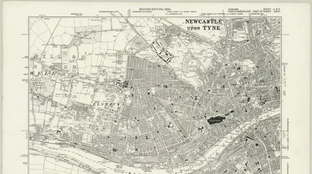
Historical Ordnance Survey maps are useful for comparing the industrial landscape across different periods. The Newcastle Historic Environment Record cites the 1899 Ordnance Survey map in its documentation of Armstrong’s works, making it a valuable reference for understanding the layout of the area near the end of the nineteenth century.
For more detailed research, readers should compare maps, heritage records and dated photographs rather than relying on a single source. This approach helps distinguish original Victorian buildings from later structures and clarifies how factory boundaries, roads and residential streets changed.
Scotswood Road’s history is best understood as part of a wider landscape. By combining local records with industrial and social history, researchers can trace the development of Newcastle’s West End from riverside manufacturing district to its modern urban form.