Denton Burn is a residential area in west Newcastle upon Tyne with a history shaped by Roman frontier construction, medieval landholding, coal extraction, industrialisation and twentieth-century suburban housebuilding. Its modern identity combines family housing, schools, local services, open space and surviving archaeological remains.
- What is Denton Burn and where is it located?
- How did Denton Burn develop before modern housing?
- When did Denton Burn become a residential suburb?
- What types of family homes are found in Denton Burn?
- How did schools and community facilities shape family life in Denton Burn?
- What historic landmarks can residents find in Denton Burn?
- How did coal mining and industry change Denton Burn?
- Is Denton Burn a good area for family life?
- Is Denton Burn safe for families?
- What should first-time buyers check before purchasing a home in Denton Burn?
- How should buyers understand Denton Burn’s heritage when assessing property?
- How is Denton Burn likely to remain historically relevant?
The area sits around four miles west of Newcastle city centre and is associated with the West Road corridor, Denton Dene, Denton Burn itself and the wider west Newcastle urban area. Its location places residential streets close to major transport routes and historic sites while retaining links to the older rural landscape that existed before Newcastle expanded westwards.
For first-time buyers and families, Denton Burn is best understood through this historical development. The housing stock reflects twentieth-century expansion rather than a single planned architectural period. The area also contains an important section of Hadrian’s Wall, including a Roman turret and surviving wall fabric, giving an ordinary residential neighbourhood an unusually strong archaeological dimension.
What is Denton Burn and where is it located?
Denton Burn is a residential suburb in west Newcastle upon Tyne, centred on the West Road corridor and Denton Dene. It lies about four miles west of Newcastle city centre and connects residential neighbourhoods with major routes towards the A1, A69 and surrounding west Newcastle communities.
The name Denton is associated with an older settlement landscape. Local historical research records Denton as meaning a homestead in a valley, reflecting the physical geography created by Denton Burn and Denton Dene. Denton Burn is a watercourse that runs roughly parallel with Silver Lonnen and Denton Road before passing through Denton Dene towards the River Tyne at Scotswood. Parts of the watercourse were culverted during the twentieth century.
The area’s physical geography is important to understanding its housing pattern. Denton Dene forms a green corridor through the urban landscape. The burn historically provided a natural drainage route, while surrounding land supported agriculture before large-scale urban development.
Today, Denton Burn forms part of the wider west Newcastle urban area. It is closely associated with Scotswood, Benwell, West Denton and other neighbouring districts. These areas developed at different speeds but became increasingly connected through industrial growth, transport improvements and residential construction.
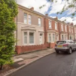
The modern postcode district is NE15. Broadwood Road, for example, contains predominantly residential properties, with semi-detached houses forming a significant part of the housing character. Recorded property information for the area also identifies many homes dating from the 1930s and 1940s.
This makes Denton Burn particularly relevant to buyers looking for established family housing rather than a predominantly new-build neighbourhood.
How did Denton Burn develop before modern housing?
Denton Burn developed from a rural landscape of farms, woodland, waterways and small settlements before industrialisation transformed the area. Roman frontier construction, medieval landholding, coal extraction and nineteenth-century transport infrastructure each changed the landscape before twentieth-century suburban housing arrived.
The Roman period provides the earliest major surviving physical evidence. Hadrian’s Wall crossed the Denton area as part of the Roman Empire’s northern frontier. Construction of Hadrian’s Wall began in AD 122 during the reign of Emperor Hadrian. The frontier extended from the Solway Firth to the River Tyne and became part of the Frontiers of the Roman Empire World Heritage Site.
Denton therefore sits within a landscape that was strategically important almost 1,900 years ago. The Roman frontier included the Wall, associated defensive features and military infrastructure. Archaeological investigations have identified surviving wall fabric beneath and alongside later development.
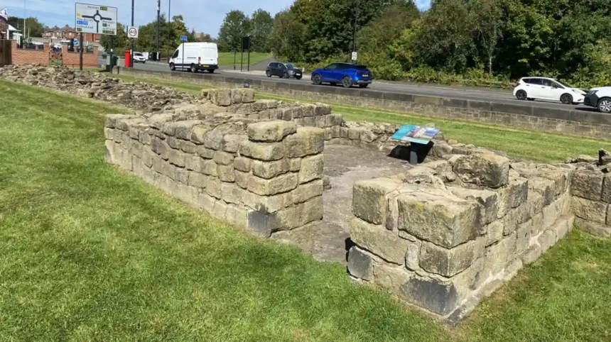
Historic England records a Roman turret at Denton Hall. The structure dates from around AD 122 and is built from sandstone. The turret is incorporated into Hadrian’s Wall and survives to several courses in height. It was first listed in 1971 and is designated Grade I. The associated archaeological monument is also scheduled.
The Roman landscape was followed by medieval settlement and agricultural use. Local historical research traces Denton’s manor through several periods of ownership. The medieval and post-medieval landscape remained substantially rural compared with the dense urban area that exists today.
Coal later became a major economic force. The Tyne and Wear Historic Environment Record identifies coal workings in Denton Burn dating to the Victorian period. A historic quarry is also recorded in the Denton area on the 1864 Ordnance Survey map.
These extractive industries changed land use. Mining required shafts, transport routes and associated infrastructure. Agricultural land increasingly became connected to industrial Newcastle.
When did Denton Burn become a residential suburb?
Denton Burn became a substantial residential suburb during the late nineteenth and twentieth centuries as Newcastle expanded westward. Large-scale housebuilding replaced farmland and older village landscapes, while roads, schools, public services and private estates connected Denton Burn to the wider city.
The transformation accelerated during the early twentieth century. Denton Burn and neighbouring Scotswood had previously been small settlements. A heritage guide produced by St James’ Heritage & Environment Group records that large-scale industrial development and housing construction transformed the area during the decades around the beginning of the twentieth century.
Housing expansion was closely connected to Newcastle’s wider response to population growth and housing demand. The Housing Act 1919, commonly known as the Addison Act, established a national framework for council housing and encouraged local authorities to build large numbers of new homes. Newcastle subsequently developed estates across the city.
Denton Burn’s growth also included private housing. Research into west Newcastle’s development records the creation of new owner-occupied estates north of council housing areas. By the beginning of the Second World War, development had filled much of the land between the original settlements of Scotswood and Denton Burn.
This explains the architectural character encountered by modern buyers. Much of the residential environment reflects inter-war and mid-twentieth-century planning rather than Victorian urban terraces.
The development pattern also created a more structured suburban landscape. Streets, gardens, schools and open areas were incorporated into residential planning. Newcastle’s urban character assessment identifies Denton Burn’s low-rise estate form, open spaces, mature trees and connections to Denton Dene as important elements of its character.
For first-time buyers, this history has a practical consequence. Property condition varies according to construction date, alterations and maintenance. Buyers of older houses should therefore assess roofs, windows, insulation, electrical systems, drainage and extensions independently rather than relying on the appearance of the wider estate.
What types of family homes are found in Denton Burn?
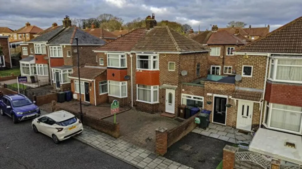
Denton Burn contains established low-rise family housing, with semi-detached houses particularly associated with twentieth-century residential development. Property layouts reflect inter-war suburban planning, later alterations and different phases of council and private housebuilding across the wider west Newcastle area.
Semi-detached housing is a defining feature of several Denton Burn residential streets. Broadwood Road, for example, contains primarily semi-detached domestic properties, with many buildings dating from the 1930s and 1940s.
This period produced homes designed around family occupation. Gardens, front boundaries and relatively generous spacing formed part of the suburban model. Newcastle’s character assessment specifically identifies the low-rise estate character and the relationship between residential streets and open land as features requiring protection in planning decisions.
The housing stock also reflects later ownership changes. Council housing formed an important part of Newcastle’s twentieth-century housing history, while Right to Buy legislation introduced during the 1980s changed patterns of tenure across the city. Newcastle City Council records the long-term decline in council housing numbers following Right to Buy while emphasising the continued role of social housing.
A first-time buyer should therefore distinguish between the physical age of a property and its current tenure history. Two houses built during the same decade can have very different levels of refurbishment.
Older properties also require attention to energy performance. Historic housing generally predates modern insulation standards. EPC information, heating systems, window condition and loft insulation should form part of the purchase assessment.
Extensions are another important consideration. Many twentieth-century family houses have undergone alterations. Buyers should confirm planning permissions, building regulations certificates and title information for significant extensions or conversions.
How did schools and community facilities shape family life in Denton Burn?
Schools and community facilities became central to Denton Burn’s suburban development as residential construction expanded. Broadwood Primary School remains a local educational institution, while earlier schools, libraries and public facilities demonstrate how twentieth-century planning linked housing with community infrastructure.
Education has a long history in the wider district. Tyne and Wear Archives records the development of schools serving Benwell and Scotswood, including the opening of Denton Road Council School in 1908 after earlier school provision became overcrowded and inadequate. The school eventually closed in 2000, with many pupils transferring to Broadwood Primary School.
Broadwood Primary School now serves children aged three to eleven and has an attached nursery. The school is located on Broadwood Road in Denton Burn and has a published admission number of 60 for its year of entry.
The development of schools reflects a wider principle in twentieth-century housing planning. Residential estates required nearby education, recreation and public services to function as complete communities.
Historical research into west Newcastle records that expanding communities were provided with facilities including schools, libraries and swimming provision. These services accompanied the rapid construction of housing before the Second World War.
Families considering a move should check current school admission arrangements directly with the relevant school and Newcastle City Council. School catchment boundaries and admission policies are administrative matters and should not be inferred solely from distance.
The educational history also gives Denton Burn importance for local historians. School records provide evidence about population growth, migration, household structure and changing social conditions during Newcastle’s industrial and suburban expansion.
What historic landmarks can residents find in Denton Burn?
Denton Burn contains nationally important Roman heritage, especially the surviving Denton Hall Turret and attached section of Hadrian’s Wall. These remains connect modern residential streets with the Roman frontier and form the area’s most important surviving archaeological landmark.
Denton Hall Turret is the clearest physical reminder of the Roman landscape. Historic England identifies it as a Grade I listed Roman turret incorporated into Hadrian’s Wall. It dates from approximately AD 122 and formed part of the frontier’s military infrastructure.
The site is particularly valuable because the Roman structure survives within an otherwise modern residential setting. Historic England’s documentation of Hadrian’s Wall records surviving wall fabric at Denton and describes archaeological evidence beneath later ground levels.
A Roman milecastle associated with the Denton section is also understood to lie beneath later development. This illustrates the archaeological complexity of the district. Modern streets do not erase the historic landscape beneath them.
Hadrian’s Wall itself has international significance. Newcastle City Council states that the monument extends for approximately 73.5 miles between Bowness-on-Solway and Wallsend. It became a World Heritage Site in 1987. Within Newcastle, the line of the frontier runs from Throckley through the city towards Walker.
Denton Burn therefore has relevance beyond local history. Its Roman remains form part of an internationally recognised archaeological landscape.
To experience this historic landscape and other local heritage attractions in person today, consult our comprehensive [Insert Anchor Text for Denton Burn Things to Do Article Here] for itineraries and visiting parameters.
How did coal mining and industry change Denton Burn?
Coal mining and industrial activity changed Denton Burn from an agricultural landscape into an increasingly connected industrial suburb. Mining, quarrying, wagonways and expanding roads altered land use before large-scale residential development covered much of the former rural landscape.
Coal extraction became important in Denton’s economic history. The Tyne and Wear Historic Environment Record identifies a Victorian coal pit in Denton Burn. The area’s historic maps also record quarrying activity.
Industrial development required transportation. Wagonways connected coal workings with markets and river transport, while roads improved links between Newcastle and surrounding settlements.
The Burn itself formed part of this industrial landscape. Its valley influenced settlement patterns and provided a natural corridor through Denton Dene. As urbanisation advanced, parts of the watercourse were culverted during the twentieth century.
Industrialisation also connected Denton Burn with Scotswood. Scotswood developed along the River Tyne and became associated with major industrial employment. The two communities were increasingly absorbed into Newcastle’s continuous urban fabric.
The decline of traditional industry produced another major change. During the later twentieth century, industrial employment contracted and older housing areas experienced clearance and redevelopment. The heritage guide for Denton Burn and Scotswood records both industrial decline and extensive housing clearance while noting the continued survival of Denton Dene as a green space.
This industrial history remains relevant to property research. Former industrial land requires appropriate planning and environmental assessment. Newcastle City Council’s contaminated land strategy identifies Denton Dene as an area affected by a long mining history and twentieth-century landfilling during the 1950s and early 1960s. The site is now used for public open space, recreational fields and community facilities.
Is Denton Burn a good area for family life?
Denton Burn offers an established family-oriented residential environment with low-rise housing, schools, open space and access to Newcastle’s wider urban services. Its suitability depends on the exact street, property condition, school requirements, transport needs and current local conditions.
The physical structure of Denton Burn supports family occupation. Many houses were constructed with gardens and suburban layouts. Broadwood Primary School provides local primary education, while Denton Dene supplies an important green-space component.
The area’s location also provides access to Newcastle’s wider employment and education infrastructure. West Road functions as a major east-west route, while connections towards the A1 and A69 support travel beyond the immediate neighbourhood.
Families should assess individual streets rather than treating Denton Burn as a uniform housing market. Housing type, traffic levels, proximity to shops, school routes, parking arrangements and access to green space vary by location.
The historical layout also influences modern neighbourhood quality. Newcastle’s urban character assessment identifies open views into Denton Dene, mature tree lines and pedestrian and cycle connections as important design features. It recommends retaining the area’s low-rise character and avoiding inappropriate high-rise development in identified character areas.
This planning framework matters for residents because local development decisions influence daylight, views, traffic, density and open-space access.

Is Denton Burn safe for families?
Denton Burn’s safety should be assessed using current police data, street-level conditions and property-specific factors rather than a single area-wide label. Northumbria Police provides crime-map information, while Newcastle also operates local community-safety measures affecting Benwell, Scotswood and Denton Burn.
Crime statistics change over time and should therefore be checked before purchasing. Northumbria Police publishes local crime-map information for Newcastle neighbourhoods, allowing residents to examine reported incidents by approximate location and category.
The police data is not a complete measure of personal safety. Crime-map locations are approximate and reporting patterns vary. Buyers should examine several months of data rather than relying on one snapshot.
Environmental conditions also form part of residential safety. Street lighting, traffic speed, pedestrian routes, parking, alleyways, vacant land and the condition of communal spaces should be inspected during both daytime and evening visits.
Newcastle City Council has also designated No Cold Calling Zones across the city. The Benwell, Scotswood and Denton Burn ward is included among Newcastle’s designated areas, forming part of a citywide programme covering 33 zones and approximately 84,799 households.
Local environmental enforcement provides another indicator of how neighbourhood problems are addressed. In 2021, Newcastle City Council used a Community Protection Notice and prosecution following complaints about a garden on Castleside Road in Denton Burn that had accumulated substantial waste.
These examples demonstrate active council enforcement rather than establishing a general safety rating for the whole district.
For families, the strongest assessment combines official police information with direct inspection. Buyers should visit prospective streets at different times, examine pedestrian access and speak with local residents before committing to a purchase.
What should first-time buyers check before purchasing a home in Denton Burn?
First-time buyers should inspect structural condition, tenure, title restrictions, planning history, environmental information, transport access, school arrangements and current crime data. Older Denton Burn houses require particular attention to maintenance because much of the housing stock dates from earlier twentieth-century construction.
The first issue is property condition. A 1930s or 1940s semi-detached house requires a professional survey that covers roof condition, damp, drainage, walls, windows, insulation and alterations.
The second issue is planning history. Extensions, loft conversions, garages and boundary changes should be checked against planning and building-control records where appropriate.
The third issue is environmental history. Denton’s mining and quarrying past means buyers should review available environmental searches. The presence of former industrial activity does not automatically make a property unsuitable, but historic land use should be properly investigated.
The fourth issue is archaeology. Hadrian’s Wall has statutory protection, and Newcastle City Council explains that development affecting designated sections of the monument requires appropriate consent. The city’s archaeology service reviews planning applications along the Roman frontier to protect the internationally significant archaeological resource.
The fifth issue is flood and drainage information. Denton Burn follows a historic watercourse, with parts of the burn culverted during the twentieth century. Buyers should rely on a property-specific environmental search rather than assuming that all streets have the same drainage conditions.
The sixth issue is energy efficiency. Buyers should review the property’s EPC, heating system, insulation and glazing. Energy upgrades are especially relevant to older family housing.
The seventh issue is transport. A property close to a major road can provide convenient connections while also creating additional traffic and noise. A viewing at peak travel times provides useful information that a weekend inspection does not.
How should buyers understand Denton Burn’s heritage when assessing property?
Denton Burn’s heritage is both an advantage and a planning consideration. Roman remains, historic landscapes, Denton Dene and older housing provide strong local character, while protected archaeology and environmental history require buyers to understand planning and property constraints.
Heritage contributes to the area’s identity. Denton Hall Turret and Hadrian’s Wall provide nationally designated archaeological interest. Denton Dene preserves part of the area’s historic landscape despite extensive twentieth-century development.
Heritage also affects development control. Hadrian’s Wall is protected through national heritage legislation and World Heritage Site management. Newcastle City Council and Tyne and Wear Archaeology Service consider development proposals along the frontier.
This does not mean ordinary houses throughout Denton Burn are historic listed buildings. The Grade I designation applies specifically to the Roman turret and associated wall section identified by Historic England. Property status must be checked individually.
The distinction is important for buyers considering extensions. A property outside a designated heritage asset can still sit within an archaeologically sensitive landscape. Professional conveyancing and planning advice therefore remain important where proposed works affect the historic frontier.
The area’s heritage is also documented through local archives. Newcastle City Council’s West Newcastle Picture History Collection contains more than 20,000 photographs and documents covering west Newcastle communities, including Denton Burn, Scotswood, Benwell, Fenham, Kenton, Lemington and Newburn.
These records provide valuable evidence for genealogists and researchers tracing changes in streets, businesses, schools and communities.
How is Denton Burn likely to remain historically relevant?
Denton Burn’s future historical relevance rests on the continued survival of Roman archaeology, Denton Dene, twentieth-century housing and documentary records. Its significance comes from the coexistence of ancient frontier remains, industrial archaeology and modern suburban development within one urban landscape.
The Roman frontier provides the strongest long-term historical connection. Hadrian’s Wall is internationally recognised and remains subject to conservation and planning controls. Newcastle’s archaeological services continue to monitor development affecting the line of the monument.
Denton Dene provides a second form of historical continuity. The landscape survived major housing expansion and industrial change. Its continued use as open space preserves part of the valley landscape that existed before modern suburbanisation.
The twentieth-century housing stock provides a third layer. Inter-war semi-detached houses, council estates, schools and community facilities demonstrate how Newcastle responded to housing demand and urban growth.
Future planning will therefore involve balancing residential needs with archaeology, open space, landscape character and environmental considerations. Newcastle’s existing Local Plan remains the basis for planning decisions while a new joint NewcastleGateshead Local Plan is being prepared. The council formally gave notice in June 2026 of its intention to begin preparing the new plan with Gateshead Council.
For residents, this means Denton Burn will continue to evolve within a planning framework that considers housing, transport, infrastructure, heritage and environmental protection.
For historians and educators, the area offers an unusually clear example of layered urban development. Roman military infrastructure, medieval landholding, coal extraction, nineteenth-century transport, inter-war housing and post-industrial change all remain connected within the same landscape.
For first-time buyers, the central lesson is practical. Denton Burn is not simply a collection of family houses west of Newcastle city centre. It is a historic landscape where housing, archaeology, open space, infrastructure and community development have accumulated over many centuries.
A sound property decision therefore requires two assessments. The first is the ordinary buyer’s assessment of price, condition, location, schools, transport and safety. The second is the historical and environmental assessment of the land, planning constraints and surrounding character.
Taken together, these factors explain Denton Burn’s distinctive position within Newcastle. Its twentieth-century family housing sits directly within a landscape that preserves evidence of Roman frontier planning, industrial extraction and rural settlement. That combination gives the suburb a clear historical identity while retaining its practical role as an established residential part of Newcastle upon Tyne.