South Gosforth sits within Newcastle upon Tyne’s northern urban landscape, close to Jesmond Dene, Gosforth High Street and the Ouseburn valley. Its present residential character developed from a much older settlement pattern shaped by farming, coal mining, transport infrastructure, Victorian expansion and the growth of Newcastle as an industrial city.
- Why is South Gosforth historically important to Newcastle?
- How did South Gosforth develop from a medieval village into a suburb?
- When did the railway transform South Gosforth?
- What role did St Nicholas Church play in South Gosforth history?
- How did Jesmond Dene influence South Gosforth’s development?
- What historic buildings can residents and visitors still see near South Gosforth?
- What makes Jesmond Dene significant for heritage and conservation?
- What is the property character around South Gosforth and Jesmond Dene?
- How does living near Jesmond Dene shape everyday life in South Gosforth?
- How accessible is South Gosforth for Newcastle travel?
- What should history enthusiasts look for when exploring South Gosforth and Jesmond Dene?
- What does South Gosforth’s history reveal about Newcastle’s wider development?
- Why does South Gosforth remain relevant for future heritage research?
The relationship between South Gosforth and Jesmond Dene is important because the two areas represent different stages of Newcastle’s development. South Gosforth preserves evidence of a medieval settlement and later suburban expansion, while Jesmond Dene preserves a deliberately designed nineteenth-century landscape associated with industrialist and engineer William Armstrong.
Today, this historical layering affects the character of housing, streets, transport routes, green space and heritage protection. Understanding that history provides useful context for anyone researching South Gosforth property, considering its residential environment, studying local architecture or tracing the development of Newcastle beyond the city centre.
Why is South Gosforth historically important to Newcastle?
South Gosforth is historically important because it preserves evidence of a medieval settlement, St Nicholas Church, coal mining, railway expansion and Victorian suburban growth beside the historic landscape of Jesmond Dene and the Ouseburn valley.
South Gosforth was not created as a modern suburb. Newcastle’s Historic Environment Record identifies South Gosforth as a medieval settlement, with documentary evidence placing it within the barony of Whalton in 1166. Two-thirds of the settlement was held by the Lisle family from the late twelfth century, while one-third was held by the Heselrig family from the mid-fourteenth century.
The settlement remained small for centuries. Four taxpayers were recorded in 1296 and five in 1312. By the 1826 election, only six voters were recorded. The historic village centre stood close to the site of St Nicholas Church.
This evidence demonstrates the difference between medieval South Gosforth and the residential district visible today. The modern neighbourhood developed substantially during the nineteenth century as Newcastle expanded beyond its historic core.
The change was linked to industrialisation, improved transport and rising demand for housing. Gosforth developed as a residential area serving Newcastle, while nearby industrial activity included coal mining and water-powered industry along the Ouseburn.
The Great North Road also influenced the area’s development. Newcastle’s Historic Environment Record describes the route through Gosforth, now associated with Gosforth High Street, as an ancient northward route that was possibly Roman in origin and certainly important during the medieval period.
South Gosforth therefore forms part of a much wider historical system connecting Newcastle with Northumberland, the Tyne industrial economy and the settlements north of the city.
How did South Gosforth develop from a medieval village into a suburb?
South Gosforth developed from a small medieval settlement into a suburban district during the nineteenth century as Newcastle expanded, railway infrastructure improved, coal mining declined, and new residential development replaced much of the earlier rural landscape.
The medieval settlement near St Nicholas Church remained relatively small for centuries. The first edition Ordnance Survey evidence described a landscape containing a farm, school and a small number of dwellings. Later nineteenth-century development transformed this pattern.
The transformation was connected to the growth of Newcastle during the Industrial Revolution. Newcastle upon Tyne expanded rapidly during the nineteenth century, with its population increasing from approximately 28,000 in 1820 to 215,000 in 1900. The city also developed major industrial complexes, including the Armstrong works at Elswick.
Industrial growth created employment and increased demand for housing. Areas north and east of the historic centre became increasingly attractive for residential development.
Gosforth experienced this process particularly strongly. The Historic Environment Record identifies High Victorian, Queen Anne Revival and Edwardian architecture within the Gosforth Conservation Area. These architectural styles demonstrate the transition from rural settlement to planned suburban neighbourhood.
South Gosforth was also influenced by nearby coal mining. Gosforth Colliery operated from the eighteenth century and was out of use by 1895. Coxlodge Colliery, including Regent and Jubilee Pits, formed another part of the area’s industrial landscape.
The closure of older industrial sites created opportunities for new land uses. Residential development gradually became a defining feature of the district.
This process explains why South Gosforth contains a mixture of older village-related buildings, nineteenth-century housing and later suburban construction rather than a single uniform architectural style.
When did the railway transform South Gosforth?
The railway transformed South Gosforth after 1864 by connecting Gosforth with Newcastle and the wider Blyth and Tyne network, encouraging suburban development and creating the transport foundation later incorporated into the Tyne and Wear Metro.
South Gosforth railway history begins with the Blyth and Tyne Railway. A station opened here as Gosforth on 27 June 1864. The station was later renamed South Gosforth in 1905 after the development of another Gosforth railway station.
The railway changed the relationship between Gosforth and Newcastle. A reliable rail connection reduced the practical separation between a previously rural settlement and the expanding city.
Railway infrastructure also supported the development of suburban housing. Victorian and Edwardian residential streets appeared as Newcastle’s population increased and households sought accommodation outside the central urban area.
The railway subsequently entered a new phase. The line became part of the Tyne and Wear Metro system, with the South Gosforth station reopening for Metro services on 11 August 1980.
The transport legacy remains important to the area’s present identity. South Gosforth is therefore not simply a residential district beside a park. It is also a location shaped by more than 160 years of railway infrastructure.
For property research, this historical development explains why transport accessibility and proximity to established residential streets became closely connected. For historical research, it demonstrates how railway investment accelerated suburbanisation across northern English cities.
The surviving transport landscape also provides a direct connection between nineteenth-century Newcastle and the modern Metro network.
What role did St Nicholas Church play in South Gosforth history?
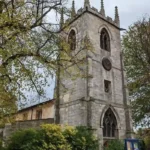
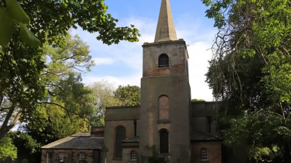
St Nicholas Church provides one of the clearest physical links between modern South Gosforth and its medieval settlement, with a medieval chapel tradition followed by the surviving 1799 tower and west end and later additions designed by John Dobson.
The religious history of South Gosforth extends back to the medieval period. Newcastle’s Historic Environment Record records an early chapel dedicated to St Nicholas, with the earliest known reference associated with a grant to Robert de Lisle probably dating from the late twelfth century.
The chapel had its own rector for a period, although it remained connected with the parish of St Nicholas in Newcastle. By 1663, the building was described as being in ruins.
A new chapel was built on the site in 1799. The surviving church contains the 1799 tower and west end, while John Dobson designed additions in 1820. Further additions followed in 1912–13 and 1950. The building is Grade II listed.
John Dobson was one of the leading architects associated with nineteenth-century Newcastle. His work in South Gosforth connects the local church with the wider architectural development of the region.
The church is historically important because its building fabric records several phases of change. Medieval religious continuity, Georgian rebuilding, nineteenth-century architectural intervention and twentieth-century adaptation are all represented within the site.
For genealogical researchers, the church and its associated burial ground also provide an important local reference point. Parish institutions historically recorded baptisms, marriages and burials, making churches central sources for reconstructing family histories.
The building therefore represents more than religious architecture. It provides physical evidence for the continuity of settlement around the historic core of South Gosforth.
How did Jesmond Dene influence South Gosforth’s development?
Jesmond Dene influenced South Gosforth by creating a major historic landscape beside the expanding suburb, combining ancient woodland, the Ouseburn, industrial remains, Victorian garden design, bridges and buildings associated with William Armstrong.
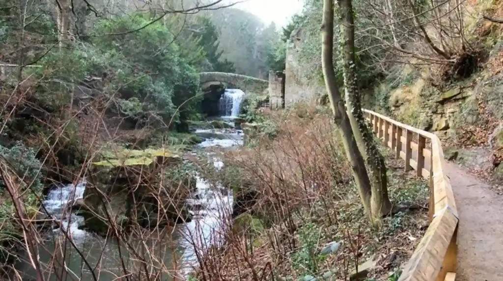
Jesmond Dene occupies a wooded valley formed by the Ouseburn. Newcastle City Council describes it as ancient woodland with geological interest, while the Historic Environment Record identifies the valley as a nineteenth-century pleasure ground extending along the Ouseburn.
Its transformation accelerated under William Armstrong, the Newcastle engineer and industrialist. By 1862, Armstrong had acquired most of the Dene and developed it as a private landscape around Jesmond Dene House. Waterfalls, a grotto and exotic planting became part of the designed environment.
The landscape was not created from an empty site. The Ouseburn had already supported industrial activity. Mills used the river’s water power, while later industrial works occupied parts of the valley.
Newcastle City Council records industrial remains within the Dene, including evidence connected with water-powered production. The site associated with Busy Cottage had operated as an ironworks before later industrial uses and eventual incorporation into Armstrong’s landscape.
Armstrong’s development therefore changed the function of the valley. An industrial landscape was partly transformed into a private pleasure ground.
In 1883 Armstrong gave Jesmond Dene to Newcastle Corporation. The park opened to the public in 1884.
That transfer established the Dene as a permanent public landscape. Its proximity to South Gosforth remains one of the defining geographical relationships shaping the area’s residential and recreational character.
What historic buildings can residents and visitors still see near South Gosforth?
Historic buildings near South Gosforth include St Nicholas Church, Jesmond Dene House, the Banqueting House, Armstrong Bridge and surviving structures associated with the Ouseburn valley, creating a concentrated record of Newcastle’s medieval, industrial and Victorian development.
Jesmond Dene House is Grade II listed by Historic England. The main house dates from 1822 and was designed by John Dobson for T.E. Headlam. Later alterations included a porch dated 1897 and work by F.W. Rich for Sir Andrew Noble.
The Banqueting House provides another major architectural reference. John Dobson designed the original building for William Armstrong in 1860–62. Richard Norman Shaw extended it in 1869–70, adding a gatehouse, reception hall and display room.
The building was designed for entertaining Armstrong’s guests and business contacts. Historic England records notable diners including Henry Marc Brunel and Thomas Sopwith. Armstrong later donated the hall and Jesmond Dene to Newcastle Corporation in 1883.
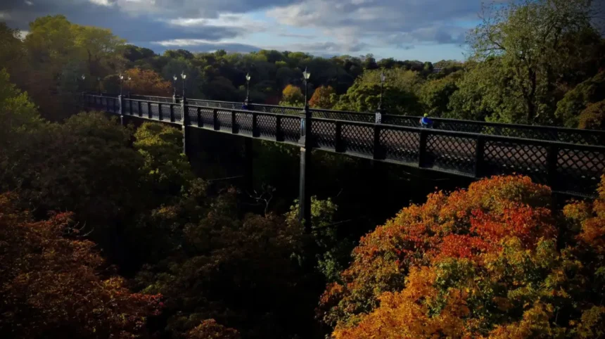
Armstrong Bridge is another significant structure. The Grade II listed bridge carries the A1058 and forms an important physical connection across the Dene.
The historic landscape also contains evidence of earlier activity. Historic England records a medieval St Mary’s Chapel, the remains of an early nineteenth-century flint mill, historic bridges and other structures within the registered park.
These buildings demonstrate the architectural range surrounding South Gosforth. The area connects medieval religious history with Georgian rebuilding, Victorian industrial wealth and nineteenth-century landscape design.
For anyone studying Newcastle’s architectural history, the concentration of surviving structures around Jesmond Dene provides an unusually clear physical record of changing land use.
What makes Jesmond Dene significant for heritage and conservation?
Jesmond Dene is significant because its historic landscape combines ancient woodland, industrial archaeology, Victorian garden design and listed structures within a Grade II registered park, while conservation controls protect the character of important surrounding areas.
Historic England placed Jesmond Dene, Armstrong Park and Heaton Park on the Register of Parks and Gardens of Special Historic Interest as a Grade II site. The listing recognises the historic landscape and its surviving features.
The registered landscape extends along the Ouseburn valley. Historic features include the remains of a flint mill, historic bridges, the Banqueting House, St Mary’s Chapel and landscape features associated with Armstrong’s nineteenth-century design.
Conservation status affects how historic places are managed. Newcastle City Council identifies Jesmond Dene and Gosforth among the city’s conservation areas and provides character statements and management documents for designated areas.
The Gosforth Conservation Area was designated in April 2002. Its character includes High Victorian, Queen Anne Revival and Edwardian buildings, alongside the traditional commercial environment of Gosforth High Street.
This distinction matters for property research. A listed building, a conservation area and a registered park are different heritage designations with different legal and planning implications.
Historic designation does not mean every building in the wider South Gosforth area is listed. It means that specific structures, landscapes or areas have recognised heritage value and are subject to particular planning considerations.
The result is a neighbourhood where new development exists alongside protected historic fabric. This relationship forms an important part of the area’s present architectural character.
What is the property character around South Gosforth and Jesmond Dene?
Property around South Gosforth and Jesmond Dene reflects nineteenth-century suburban expansion, later twentieth-century development and the survival of historic buildings, with architectural character varying according to street, age, proximity to the Dene and heritage designation.
South Gosforth’s housing character developed primarily during the period when Gosforth changed from a rural settlement into a Newcastle suburb.
The Gosforth Conservation Area provides evidence of the architectural transition. Newcastle’s Historic Environment Record identifies High Victorian, Queen Anne Revival and Edwardian housing within the designated area.
This architectural history is important when considering property around South Gosforth. Older streets can contain houses designed during the expansion of Newcastle’s professional and industrial middle classes. Later housing reflects changing twentieth-century requirements, construction methods and household patterns.
The relationship with Jesmond Dene also creates a distinctive environmental context. The Dene contains mature woodland, steep valley sides, paths and the Ouseburn. Newcastle City Council identifies the park as an established green space with extensive walking routes and historic features.
Property close to a historic landscape is therefore influenced by more than building age. Street layout, mature vegetation, views, access routes and planning controls also contribute to local character.
Potential buyers researching historic properties should distinguish between architectural appearance and formal heritage status. A property that looks Victorian is not automatically listed. Conversely, a property within or close to a conservation area can be subject to planning considerations even when the individual building is not listed.
For accurate property research, the relevant Newcastle City Council planning information and Historic England listing should be checked against the exact address.
How does living near Jesmond Dene shape everyday life in South Gosforth?
Living near Jesmond Dene connects South Gosforth with a large historic green landscape containing walking routes, woodland, the Ouseburn, Pets’ Corner, a visitor centre and links towards Armstrong Park and Heaton Park.
Jesmond Dene is an active public park rather than a preserved landscape that exists only for historical study. Newcastle City Council provides paths through the Dene and connections towards neighbouring green spaces.
The landscape includes mature woodland, steep valley sides and the Ouseburn. Wildlife recorded by the council includes otters, kingfishers and dippers associated with the river environment.
Pets’ Corner has operated since the 1960s. The facility was established to give children opportunities to experience farm animals and learn about animal care. It remains part of the visitor offer within Jesmond Dene.
Millfield House also contributes to the visitor infrastructure. The building dates from an earlier nineteenth-century phase and was extended in 1876 by architect Frank West Rich for banker Robert G. Hoare. It now serves as a visitor centre and ranger headquarters.
The Dene also connects to Armstrong Park. Newcastle City Council records that Armstrong Park was gifted to Newcastle in 1878 and opened in 1879. It contains woodland, grassland, recreation facilities and a restored post-medieval watermill.
These facilities make the historic landscape relevant to everyday residential life. The Dene functions as a recreational resource, an educational environment and a heritage landscape.
To explore the area beyond its residential history, consult our comprehensive for itineraries and visiting information.
How accessible is South Gosforth for Newcastle travel?
South Gosforth has a long-established public transport connection with Newcastle, beginning with the 1864 railway and continuing through the Tyne and Wear Metro, while road routes and nearby bus services connect the suburb with surrounding districts.
Transport has been central to South Gosforth’s development since the nineteenth century. The opening of the Gosforth railway station in 1864 connected the settlement to the expanding railway network.
The station became South Gosforth in 1905. The railway was later incorporated into the Tyne and Wear Metro, with Metro services beginning at the station in 1980.
This continuity is historically significant. Many suburban districts developed around transport infrastructure during the nineteenth and twentieth centuries. South Gosforth provides a clear local example of this process.
Jesmond Dene also has established road and public transport access. Newcastle City Council identifies bus stops on Jesmond Dene Road and nearby Metro stations including Jesmond and West Jesmond for access to the Dene’s visitor facilities.
For residents, transport accessibility is therefore part of the area’s physical structure rather than a recent addition.
For historical researchers, the railway provides evidence of the wider process of suburbanisation. The station represents the point where a historically rural settlement became increasingly integrated into Newcastle’s urban transport system.
The continued use of the railway corridor through Metro infrastructure also demonstrates how older transport routes can survive while their technology and function change.
What should history enthusiasts look for when exploring South Gosforth and Jesmond Dene?
History enthusiasts should examine St Nicholas Church, the old settlement area, railway infrastructure, Jesmond Dene’s industrial remains, Armstrong Bridge, the Banqueting House and surviving landscape features to understand how South Gosforth changed from village to suburb.
A historical exploration should begin around St Nicholas Church because the church provides the strongest connection with medieval South Gosforth. Its documented history reaches back to the medieval chapel tradition, while the surviving building records rebuilding from 1799 onward.
The next historical layer is the railway. South Gosforth station represents the nineteenth-century transformation of the settlement into a connected suburb. The 1864 opening and later 1905 renaming establish clear dates for the transport transition.
Jesmond Dene then reveals a different aspect of Newcastle’s development. Its industrial archaeology demonstrates the importance of water power and manufacturing before Armstrong transformed part of the valley into a private landscape.
The Banqueting House demonstrates the architectural culture of Victorian industrial wealth. Its designers, John Dobson and Richard Norman Shaw, were major figures in nineteenth-century architecture, while its association with Armstrong connects the site to Newcastle’s industrial history.
Armstrong Bridge provides another visible landmark. The Grade II listing recognises its architectural and historic importance.
The Dene’s landscape also contains evidence of medieval, industrial and Victorian activity. Historic England records the remains of St Mary’s Chapel, a historic mill, bridges and designed planting within the registered landscape.
Together, these sites form a chronological sequence. Medieval settlement came first, followed by agricultural and industrial use, Victorian suburban expansion and public park development, and finally modern metropolitan integration.
What does South Gosforth’s history reveal about Newcastle’s wider development?
South Gosforth demonstrates how Newcastle expanded through interconnected processes: medieval settlement, industrialisation, coal extraction, railway construction, Victorian housing growth, public park creation and twentieth-century transport modernisation.
The history of South Gosforth is closely connected with the transformation of Newcastle from a comparatively compact settlement into a major industrial city.
The medieval village was small and agriculturally oriented. Documentary records show only a handful of taxpayers and voters over several centuries.
Industrialisation changed the economic geography. Coal mining affected Gosforth, while the Ouseburn supported water-powered industry. The development of Newcastle’s major industrial works increased demand for labour and housing.
Railways then accelerated suburban integration. The 1864 railway connection gave Gosforth direct access to the growing urban economy.
At the same time, wealthy industrial figures reshaped nearby landscapes. William Armstrong transformed Jesmond Dene and later transferred it to public ownership.
The result was a distinctive combination of urban development and protected green space. Housing expansion did not eliminate every earlier landscape feature. Churches, historic roads, industrial archaeology, railway infrastructure and the Dene remain visible.
This history also explains why the area is relevant to educators and heritage researchers. South Gosforth provides a compact study of urban change in which economic development, transport, architecture, land ownership and public recreation can be examined within a relatively small geographical area.
Why does South Gosforth remain relevant for future heritage research?
South Gosforth remains historically relevant because its surviving buildings, archaeological records, railway infrastructure, conservation areas and Jesmond Dene landscape preserve evidence of changing settlement, industry, architecture, transport and public space across more than eight centuries.
Future research into South Gosforth depends on preserving both physical structures and documentary evidence.
The Newcastle Historic Environment Record provides archaeological and historical information about sites such as South Gosforth village, St Nicholas Church and Jesmond Dene. Historic England provides statutory information for listed buildings and registered parks.
These records allow researchers to compare historical maps, architectural evidence, archaeological investigations and written sources.
Jesmond Dene is particularly important because its landscape preserves evidence from several periods. The Historic England registration identifies medieval remains, industrial structures, Victorian landscape design and later public-park features within the wider historic environment.
South Gosforth also provides a valuable case study in suburban history. Its development demonstrates how a medieval settlement can become part of a modern city while retaining identifiable traces of its earlier form.
For genealogists, church history and parish records provide another research pathway. For architectural historians, listed buildings and conservation areas provide evidence of changing design. For environmental historians, the Ouseburn and Jesmond Dene reveal how industrial water use and designed landscapes interacted.
For property researchers, the historical record explains why the area’s character varies from street to street. Building age, architectural style, transport infrastructure, conservation controls and proximity to historic green space all reflect different phases of Newcastle’s growth.
South Gosforth is therefore best understood as a layered historic suburb. Its present residential identity rests on foundations created by medieval settlement, eighteenth- and nineteenth-century industry, Victorian suburbanisation, railway expansion and the public preservation of Jesmond Dene.
That continuity gives the area lasting value for residents, visitors, educators and researchers examining the historical development of Newcastle upon Tyne.